MyTopo
Covington Tennessee US Topo Map
Couldn't load pickup availability
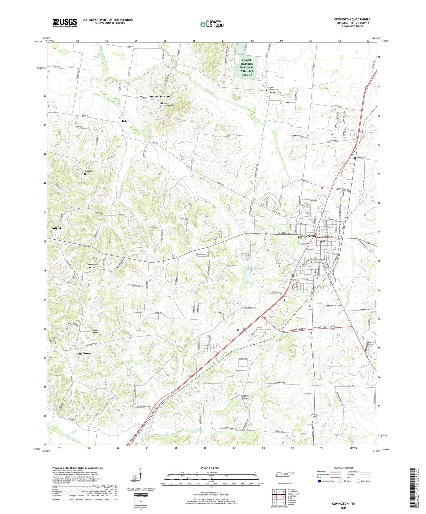
2022 topographic map quadrangle Covington in the state of Tennessee. Scale: 1:24000. Based on the newly updated USGS 7.5' US Topo map series, this map is in the following counties: Tipton. The map contains contour data, water features, and other items you are used to seeing on USGS maps, but also has updated roads and other features. This is the next generation of topographic maps. Printed on high-quality waterproof paper with UV fade-resistant inks.
Quads adjacent to this one:
West: Gilt Edge
Northwest: Golddust
North: Fort Pillow
Northeast: Ripley South
East: Gift
Southeast: Mason
South: Brighton
Southwest: Munford
This map covers the same area as the classic USGS quad with code o35089e6.
Contains the following named places: Associated Reformed Presbyterian Church of Covington, Avery Cemetery, Avery Chapel, Avreet, Avreet School, Baptist Memorial Hospital Tipton, Baskin Airport, Bethel Chapel Pentecostal Church of God, Bride, Bull Run Airport, Canaan Baptist Church, Cates Airport, Central Christian Church, Church of Christ, Church of God Holiness, City of Covington, Cobb Memorial Park, Collins Chapel Christian Methodist Episcopal Church, Country Wood, Covington, Covington Church of God in Christ, Covington City Hall, Covington Country Club, Covington Crestview Elementary School, Covington Division, Covington Elementary School, Covington Fire Department North Station, Covington Fire Department South Station, Covington High School, Covington Memorial Gardens, Covington Police Department, Covington Post Office, Covington Recreation Center, Covington School, Covington State Vocational Technical School, First Baptist Church, First Presbyterian Church, First United Methodist Church, Frazier Recreation Center, Frazier School, Green Hills, Holly Grove, Holly Grove Cumberland Presbyterian Church, Holly Grove School, Holmes Elementary School, Hyde Park Methodist Church, Indian Creek Cemetery, Indian Creek Church, Jones Dam, Jones Lake, Kings Chapel, Leighs, Leighs Chapel, Leighs Chapel Cemetery, Leighs Chapel School, Liberty Baptist Church, Med Care Ambulance Tipton, Melrose School, Midway Church, Mount Lebanon, Mount Lebanon Cemetery, Mount Lebanon Church, Mount Zion Baptist Church, Nolan Creek, North Industrial Park, Oak Grove Baptist Church, Owen School, Petty Grove School, Pisgah Church, Pleasant Hill Church, Quail Creek, Rocky Branch, Rural / Metro Ambulance Tipton County - Covington Station, Saint John Church, Saint John School, Saint Matthews Episcopal Church, Shelton Park, Shiloh Cemetery, Smiths Grove Church, South Industrial Park, Tatlock Lake, Tatlock Lake Dam, Tipton County Courthouse, Tipton County Health Center, Tipton County Justice Building, Tipton County Public Library, Tipton County Sheriff's Office, Townsend Cemetery, Trinity Church, Walton Cemetery, WKBL-AM (Covington), WKBL-FM (Covington), ZIP Code: 38019