MyTopo
Hillsdale Tennessee US Topo Map
Couldn't load pickup availability
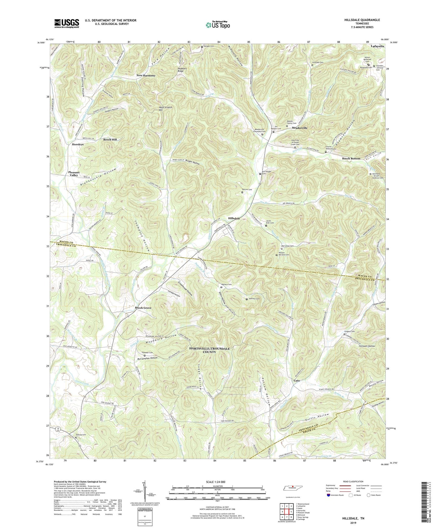
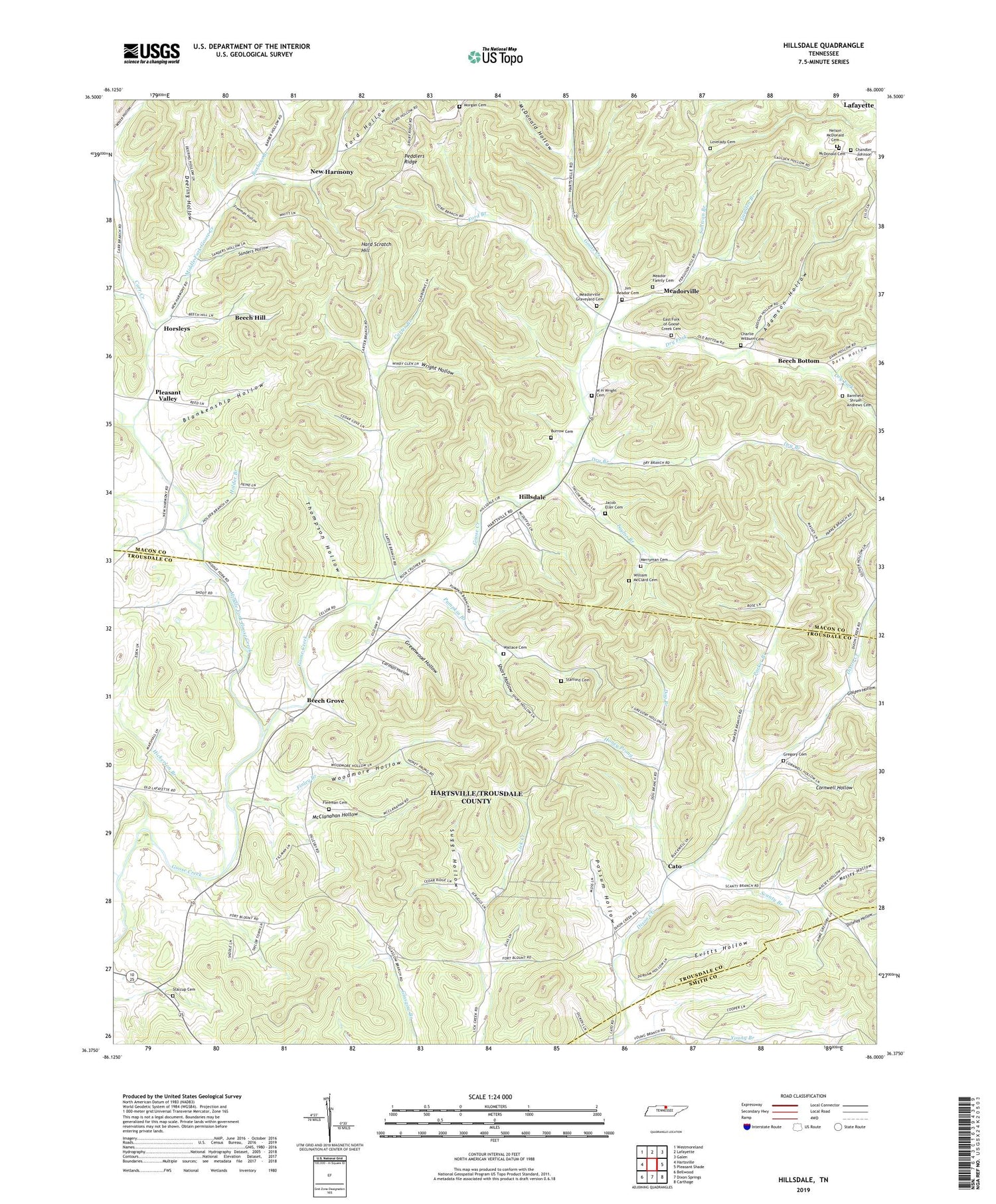
2019 topographic map quadrangle Hillsdale in the state of Tennessee. Scale: 1:24000. Based on the newly updated USGS 7.5' US Topo map series, this map is in the following counties: Macon, Trousdale, Smith. The map contains contour data, water features, and other items you are used to seeing on USGS maps, but also has updated roads and other features. This is the next generation of topographic maps. Printed on high-quality waterproof paper with UV fade-resistant inks.
Quads adjacent to this one:
West: Hartsville
Northwest: Westmoreland
North: Lafayette
Northeast: Galen
East: Pleasant Shade
Southeast: Carthage
South: Dixon Springs
Southwest: Bellwood
Contains the following named places: Adamson Hollow, Barbers Branch, Barnfield Cemetery, Beech Bottom, Beech Grove, Beech Grove School, Beech Grove United Methodist Church, Beech Hill, Beech Hill School, Blankenship Hollow, Carman Hollow, Carr Creek, Carter Branch, Cato, Cato School, Chandler -Johnson Cemetery, Charlie Wilburn Cemetery, Commissioner District 15, Commissioner District 2, Commissioner District 3, Commissioner District 7, Cornwell Hollow, Dark Hollow, Dark Shrum Branch, Deering Hollow, Dillehay Hollow, Dixon Creek Church, Dog Branch, Dry Branch, Dry Fork, East Fork of Goose Creek Cemetery, Echo Creek, Evitts Hollow, Finley Branch, Fleeman Cemetery, Ford Branch, Ford Hollow, Freeman Hollow, Gaulden Branch, Golden Hollow, Goodwill Missionary Baptist Church, Greenwood Hollow, Gregory Cemetery, Hard Scratch Hill, Haynie Branch, Hickerson Branch, Hillsdale, Hillsdale Church, Hillsdale Quarry, Holder Branch, Honey Prong, Horsley School, Horsleys, Jacob Eller Cemetery, Jim Meador Cemetery, Lovelady Cemetery, Massey Hollow, McClanahan Hollow, McDonald Cemetery, McDonald Hollow, Meador Family Cemetery, Meadorville, Meadorville Baptist Church, Meadorville Graveyard Cemetery, Merryman Cemetery, Middle Fork Goose Creek, Morgan Cemetery, Nelson Mcdonald Cemetery, New Harmony, New Harmony Baptist Church, North Fork Scanty Branch, Old Bottom School, Parker Branch, Peddlers Ridge, Pleasant Valley, Pleasant Valley United Methodist Church, Possum Hollow, Pumpkin Branch, Sanders Hollow, Scanty Branch, Short Hollow, South Fork Young Branch, Stafford Cemetery, Stalcup Cemetery, Suggs Hollow, Sullivan Branch, Taylor Branch, Taylor Burrow Cemetery, Thompson Hollow, W H Wright Cemetery, Wallace Cemetery, William McClard Cemetery, Woodmore Hollow, Wright Hollow, ZIP Code: 37057