MyTopo
Lafayette Tennessee US Topo Map
Couldn't load pickup availability
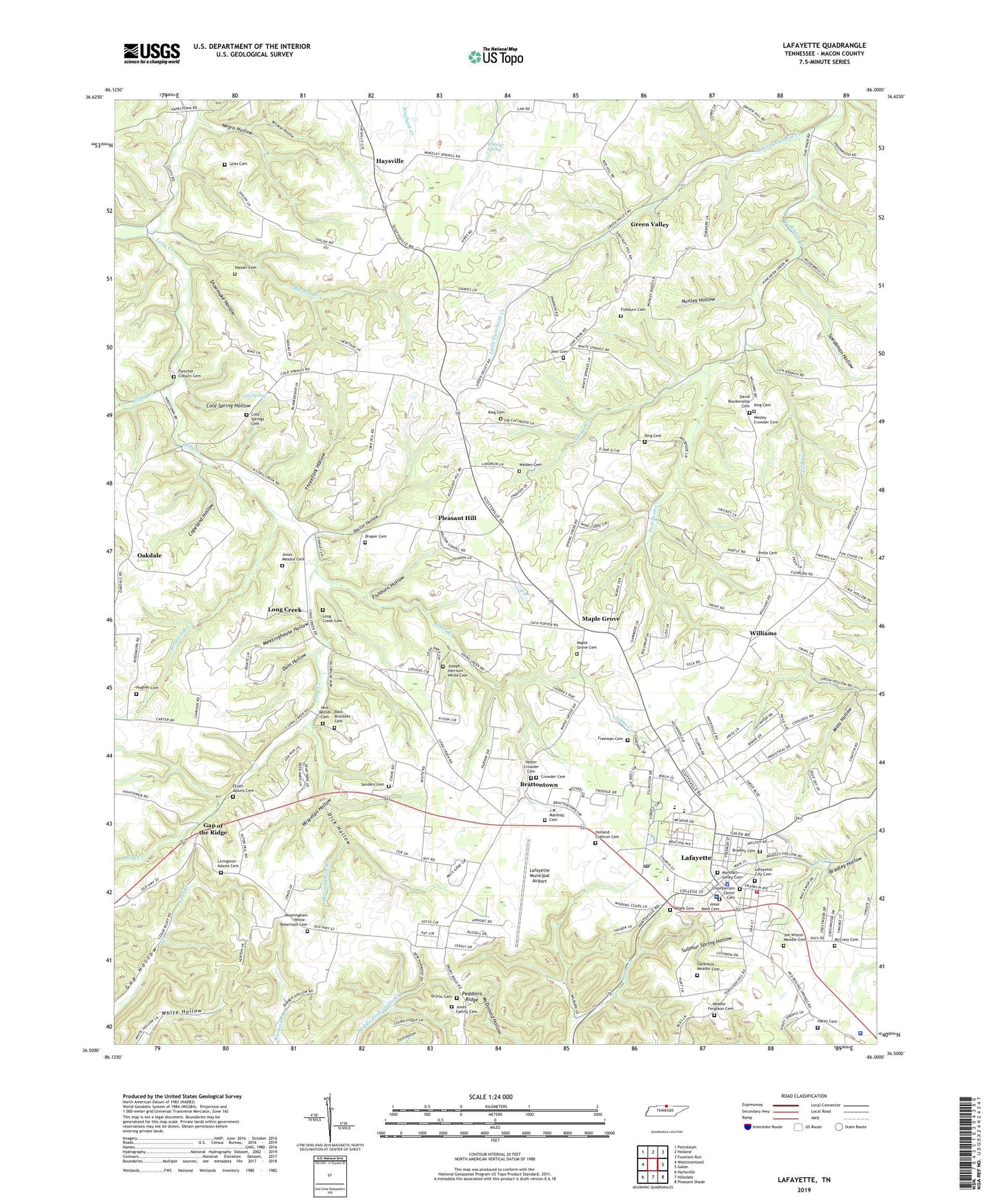
2022 topographic map quadrangle Lafayette in the state of Tennessee. Scale: 1:24000. Based on the newly updated USGS 7.5' US Topo map series, this map is in the following counties: Macon. The map contains contour data, water features, and other items you are used to seeing on USGS maps, but also has updated roads and other features. This is the next generation of topographic maps. Printed on high-quality waterproof paper with UV fade-resistant inks.
Quads adjacent to this one:
West: Westmoreland
Northwest: Petroleum
North: Holland
Northeast: Fountain Run
East: Galen
Southeast: Pleasant Shade
South: Hillsdale
Southwest: Hartsville
This map covers the same area as the classic USGS quad with code o36086e1.
Contains the following named places: Bass Brockett Cemetery, Blankenship Cemetery, Bradley Cemetery, Brattontown, Central School, Chamberlain - Carter Cemetery, City of Lafayette, Cliburn Cemetery, Clifty Creek, Cold Spring, Cold Spring Hollow, Cold Springs Cemetery, Commissioner District 10, Commissioner District 13, Commissioner District 14, Commissioner District 16, Commissioner District 17, Commissioner District 18, Commissioner District 8, Commissioner District 9, Copeland Hollow, Crowder Cemetery, Dick Hollow, Doctor Hollow, Doss Hollow, Draper Cemetery, Drurys Cemetery, Elijah Adams Cemetery, Fairlane Elementary School, Fishburn - King Cemetery, Fishburn Cemetery, Fishburn Hollow, Freeman Cemetery, Galbraith - Meador Cemetery, Gap of the Ridge, Green Valley, Haley Cemetery, Harper Cemetery, Haysville, Haysville School, Haysville United Methodist Church, Holland - Cothron Cemetery, Hughes Cemetery, J M Marshall Cemetery, Jent Cemetery, Joe Wilson Meador Cemetery, Johns Creek, Jones Family Cemetery, Joseph Harrison White Cemetery, Keystone School, King Cemetery, Lafayette, Lafayette City Cemetery, Lafayette City Hall, Lafayette Division, Lafayette Fire Department, Lafayette First Baptist Church, Lafayette Industrial Park, Lafayette Municipal Airport, Lafayette Police Department, Lafayette Post Office, Lick Branch, Little Puncheon Creek, Livingston - Adams Cemetery, Long Creek, Long Creek Baptist Church, Long Creek Cemetery, Lyles Cemetery, Macon County, Macon County Courthouse, Macon County EMS, Macon County General Hospital, Macon County Golf Course, Macon County High School, Macon County Park, Macon County Sheriff's Office, Malden Branch, Maple Grove, Maple Grove Cemetery, Maple Grove School, Marshall - Selley Cemetery, McCrary Cemetery, Meador - Ferguson Cemetery, Meador Cemetery, Meetinghouse Hollow, Mooningham - White - Robertson Cemetery, Mooningham Branch, Negro Hollow, New Bethel Cemetery, New Bethel Church, Nunley Hollow, Oakdale, Oakdale Church, Oakdale School, Pleasant Hill, Purtle Cemetery, Roark Cemetery, Sanders Cemetery, Shoemake Hollow, Speakman Hollow, Spring Creek, Spring Creek Church, Stratton Branch, Sulphur Spring Hollow, Testament Baptist Church, Threefork Hollow, Vester Crowder Cemetery, Walden Cemetery, WEEN-AM (Lafayette), Wesley Crowder Cemetery, West Cemetery, West Fork Long Creek, Wheeler Spring, Wildcat Hollow, Williams, Williams School, Wiseman Hollow, ZIP Code: 37083