MyTopo
Bryan East Texas US Topo Map
Couldn't load pickup availability
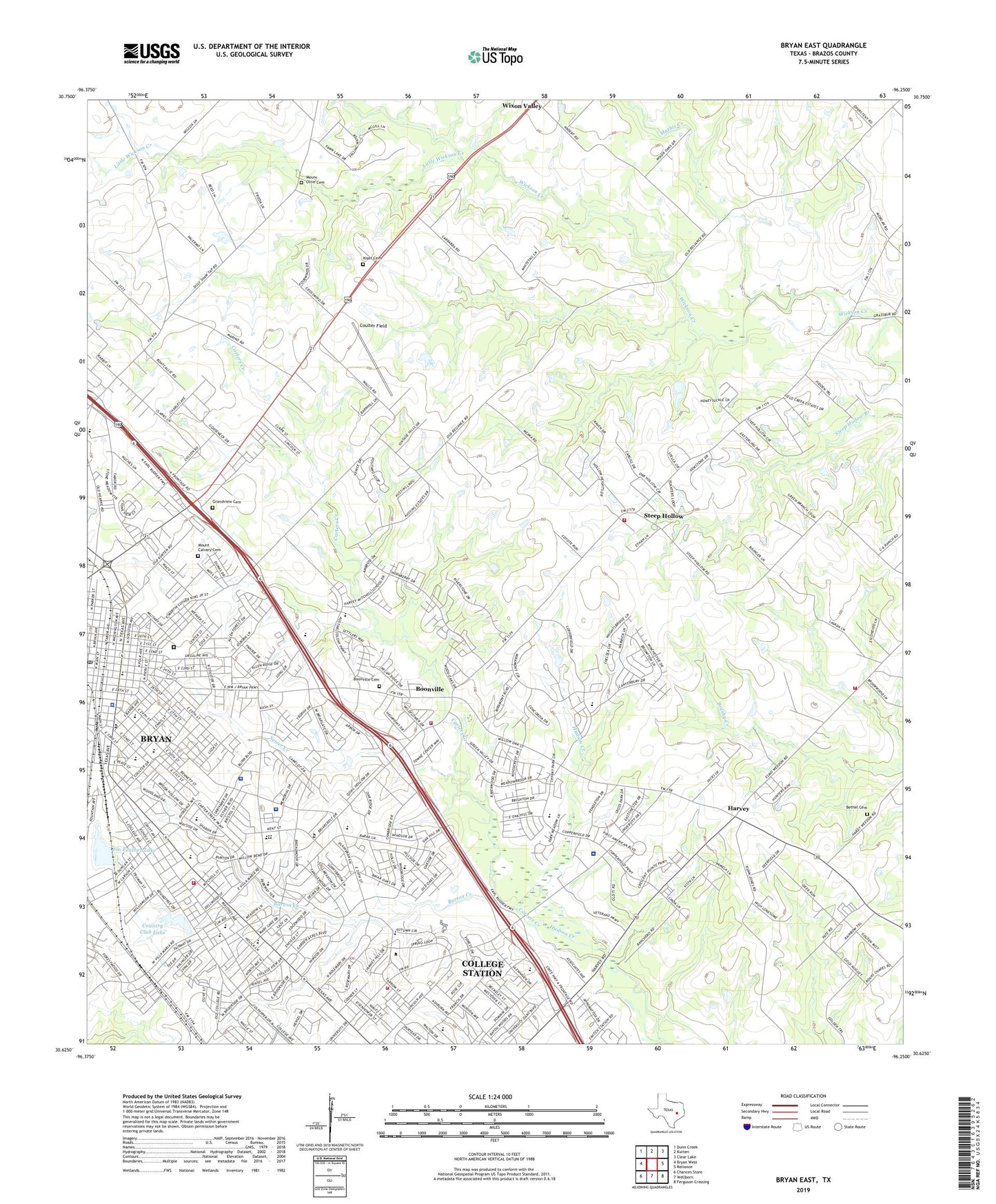
2022 topographic map quadrangle Bryan East in the state of Texas. Scale: 1:24000. Based on the newly updated USGS 7.5' US Topo map series, this map is in the following counties: Brazos. The map contains contour data, water features, and other items you are used to seeing on USGS maps, but also has updated roads and other features. This is the next generation of topographic maps. Printed on high-quality waterproof paper with UV fade-resistant inks.
Quads adjacent to this one:
West: Bryan West
Northwest: Dunn Creek
North: Kurten
Northeast: Clear Lake
East: Reliance
Southeast: Ferguson Crossing
South: Wellborn
Southwest: Chances Store
This map covers the same area as the classic USGS quad with code o30096f3.
Contains the following named places: Allen Academy, Allen Academy Memorial Hall, Allen Lake, Alton Bowen Elementary School, Armstrong House-Allen Academy, Austin High School, Baker Field, Beacon Church, Bethel Cemetery, Boonville, Boonville Cemetery, Brazos County, Brazos County Constable's Office Precinct 2, Brazos County Constable's Office Precinct 4, Brazos County Park, Brazos County Precinct 3 Volunteer Fire Department Station 1, Brazos County Precinct 3 Volunteer Fire Department Station 2, Brazos Valley Museum of Natural History, Briarcrest Country Club, Bright Light Church, Bronco Field, Bronco Stadium, Bryan, Bryan Alternative Center, Bryan Carnegie Library, Bryan City Cemetery, Bryan City Hall, Bryan City Marshal, Bryan Compress and Warehouse, Bryan County Courthouse, Bryan Fire Department Station 2, Bryan Fire Department Station 3, Bryan High School, Bryan High School at Lamar, Bryan Police Department, Bryan Post Office, Bryan-College Station Division, Bunton Park, Burton Creek, Cavitt House, College Hills Elementary School, College Station, Coulter Field, Country Club Lake, Country Club Lake Dam, Crockett Elementary School, Crockett School, Downtown Bryan Post Office, E A Kemp House, East Side Historic District, Edward J Jenkins House, English-Dansby House, Eugene Edge House, Fannin Elementary School, Fannin School, Federal Prison Camp Bryan, Fin Feather Lake, Fin-Feather Lake Dam, First Baptist Church, First National Bank and Trust Building, First State Bank and Trust Building, Grandview Cemetery, Guardian Emergency Medical Services, Harvey, Haswell Memorial Park, Henderson Elementary School, Hensel Park, Howell House, Hudson Creek, Humpty Dumpty Store, J M Jones House, Johnson Elementary School, KAGC-AM (Bryan), KAMU-FM (College Station), KAMU-TV (College Station), KBMA-FM (Bryan), Kizer Cemetery, KKYS-FM (Bryan), KORA-FM (Bryan), KTAM-AM (Bryan), KTSR-FM (College Station), Lamar Junior High School, Legacy Emergency Medical Services, Little Wickson Creek, Los Hermonos School, Macedonia Church, Mathis Creek, McDougal-Jones House, Methodist School, Minnie Zulch Zimmerman House, Moore House, Mount Calvary Cemetery, Mount Enterprise Church, Mount Olive Cemetery, New Liberty Church, Noto House, Old Sinclair Station, Parker Lumber Company Complex, Phi Air Medical 12 Bryan, R O Allen House-Allen Academy, Ridgecrest Shopping Center, Roans Chapel, Roans Chapel Cemetery, Ross School, Roy C Stone House, Sadie Thomas Memorial Park, Saint Andrews Episcopal Church, Saint Joseph Health Regional Hospital, Saint Joseph Health Rehabilitation Center, Saint Joseph Hospital Heliport, Saint Joseph Regional Health Center Emergency Medical and Transportation Services, Saint Joseph School, Sam Houston Elementary School, Sam Rayburn Middle School, Sewer Creek, Steep Hollow, Steep Hollow Cemetery, Stephen F Austin Middle School, Sul Ross Elementary School, Sul Ross Park, Tanglewood Park, Temple Freda, The Physicians Centre Hospital, Townshire Shopping Center, Travis Park, Travis School, Viking Park Baseball - Bryan High School, Viking Park Softball - Bryan High School, Viking Stadium, Walter J Higgs House, Washington School, Williamson Park, WTAW-AM (College Station), ZIP Codes: 77801, 77802