MyTopo
Liberty Texas US Topo Map
Couldn't load pickup availability
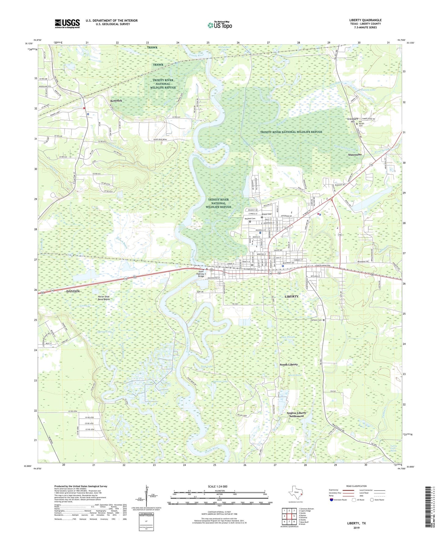
2022 topographic map quadrangle Liberty in the state of Texas. Scale: 1:24000. Based on the newly updated USGS 7.5' US Topo map series, this map is in the following counties: Liberty. The map contains contour data, water features, and other items you are used to seeing on USGS maps, but also has updated roads and other features. This is the next generation of topographic maps. Printed on high-quality waterproof paper with UV fade-resistant inks.
Quads adjacent to this one:
West: Dayton
Northwest: Simmons Bottom
North: Capers Ridge
Northeast: Hardin
East: Daisetta
Southeast: Shiloh
South: Moss Bluff
Southwest: Sheeks
This map covers the same area as the classic USGS quad with code o30094a7.
Contains the following named places: Abbott Creek, Atascosito, Beards Marsh, Big Bayou, Bowie Creek, Branch Cemetery, Champ d'Asile, City of Liberty, City of Liberty Fire Department, Clayton Bayou, Cleveland-Partlow House, Cross Bayou, Cypress Lake, Daniel Ranch, Daniels Lake, Daniels Lake Dam, Day Lake, Duncan Lake, Fairlawn Cemetery, Fairlawn Memorial Park, First United Methodist Church of Liberty, French Bayou, French Creek, Gillen Bayou, Graveyard Hill, Gulf Coast High School, Gulf Coast High School - Cleveland, Gulf Coast High School - Dayton, Gulf Coast High School - Liberty, Gum Slough, Hardin - Chambers Center, Hardin - Chambers Education Center, Hardin - Chambers Learning Center, Hayes Park, Horse Shoe Bend Bayou, Horseshoe Lake, Immaculate Conception Church, Josie Bayou, Josie Lake, Josie Lake Levee, Kenefick, Kenefick City Hall, Kenefick Police Department, Kenefick Volunteer Fire and Rescue, Kersting Hospital, KPXE-AM (Liberty), Lake Bayou, Lake Liberty, Liberty, Liberty City Hall, Liberty County Constable's Office Precinct 1, Liberty County Courthouse, Liberty County Jail, Liberty County Sheriff's Department - Detective, Liberty County Sheriff's Department - Identification, Liberty County Sheriff's Office, Liberty Dayton Regional Medical Center, Liberty Elementary School, Liberty Fire Department, Liberty High School, Liberty Middle School, Liberty Police Department, Liberty Post Office, Liberty Stadium, Liberty-Dayton Division, Linney Creek, Mill Creek, My Heliport, Negros Liberty Settlement, Neyland Cemetery, North Height Tabernacle, Old Hardin Cemetery, Palmer Bayou, Pleasant Hill Church, Pruett Bayou, Saint Johns Church, Saint Pauls Church, Saint Stephens Episcopal Church, San Jacinto Elementary School, Sandune, Snag Lake, South Liberty, South Liberty Oil Field, Spring Branch, State Highway 3 Bridge, Town of Kenefick, Trinity Valley Baptist Church, Turkey Creek, Turkey Creek Church, Twin Lake, West Liberty High School, Wood Spring Creek