MyTopo
Moody Texas US Topo Map
Couldn't load pickup availability
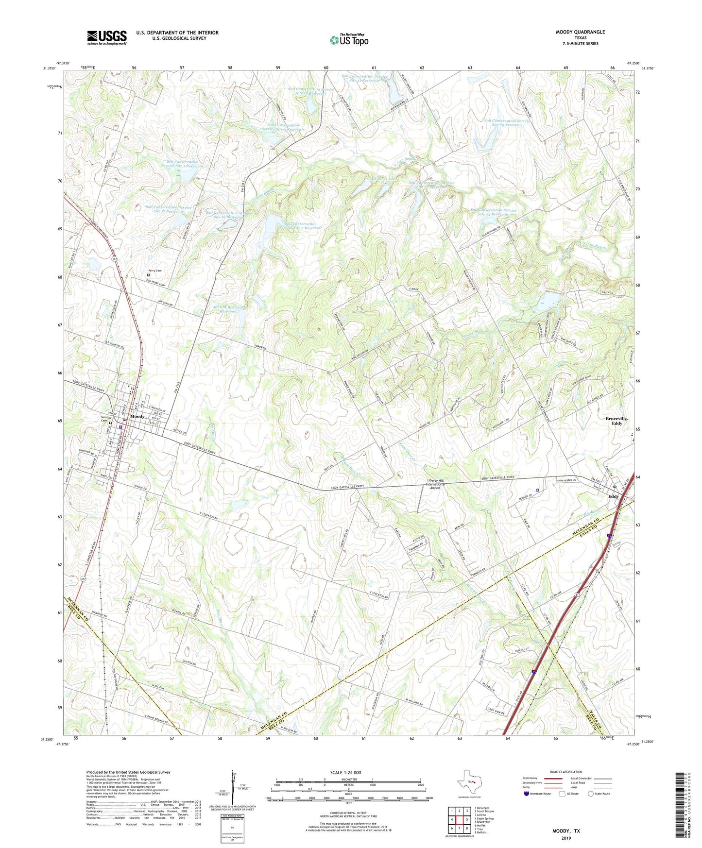
2022 topographic map quadrangle Moody in the state of Texas. Scale: 1:24000. Based on the newly updated USGS 7.5' US Topo map series, this map is in the following counties: McLennan, Bell, Falls. The map contains contour data, water features, and other items you are used to seeing on USGS maps, but also has updated roads and other features. This is the next generation of topographic maps. Printed on high-quality waterproof paper with UV fade-resistant inks.
Quads adjacent to this one:
West: Eagle Springs
Northwest: McGregor
North: South Bosque
Northeast: Lorena
East: Bruceville
Southeast: Belfalls
South: Troy
Southwest: Moffat
This map covers the same area as the classic USGS quad with code o31097c3.
Contains the following named places: Bethany Church, Bruceville-Eddy, Church of Christ - Moody, City of Moody, East Fork Deer Creek, Eddy, Eddy Post Office, First Baptist Church of Moody, Foster Branch, John M Brinegar Dam, John M Brinegar Reservoir, KCEN-TV (Bruceville-Eddy), KNFO-FM (Waco), KWKT-TV (Waco), KWTX-FM (Waco), KWTX-TV (Waco), KXXV-TV (Waco), Liberty Hill Church, Liberty Hill International Airport, Mattie Neely Park, McGinnes Lake, McGinnes Lake Dam, Moody, Moody City Hall, Moody Elementary School, Moody Intermediate School, Moody Middle School, Moody Police Department, Moody Post Office, Moody Pre - Kindergarten School, Moody Volunteer Fire Department and Emergency Medical Services, Moody-Lorena Division, Naler Cemetery, Nealy Park, Perry Cemetery, Rolling Hills Country Club Lake, Rolling Hills Country Club Lake Dam, Soil Conservation Service Site 1 Dam, Soil Conservation Service Site 1 Reservoir, Soil Conservation Service Site 17 Dam, Soil Conservation Service Site 17 Reservoir, Soil Conservation Service Site 18 Dam, Soil Conservation Service Site 18 Reservoir, Soil Conservation Service Site 19 Dam, Soil Conservation Service Site 19 Reservoir, Soil Conservation Service Site 2 Dam, Soil Conservation Service Site 2 Reservoir, Soil Conservation Service Site 20 Dam, Soil Conservation Service Site 20 Reservoir, Soil Conservation Service Site 21 Dam, Soil Conservation Service Site 21 Reservoir, Soil Conservation Service Site 22 Dam, Soil Conservation Service Site 22 Reservoir, Soil Conservation Service Site 23 Dam, Soil Conservation Service Site 23 Reservoir, Soil Conservation Service Site 24 Dam, Soil Conservation Service Site 24 Reservoir, Soil Conservation Service Site 3 Dam, Soil Conservation Service Site 3 Reservoir, Soil Conservation Service Site 4 Dam, Soil Conservation Service Site 4 Reservoir, WACO-FM (Waco), West Fork Deer Creek