MyTopo
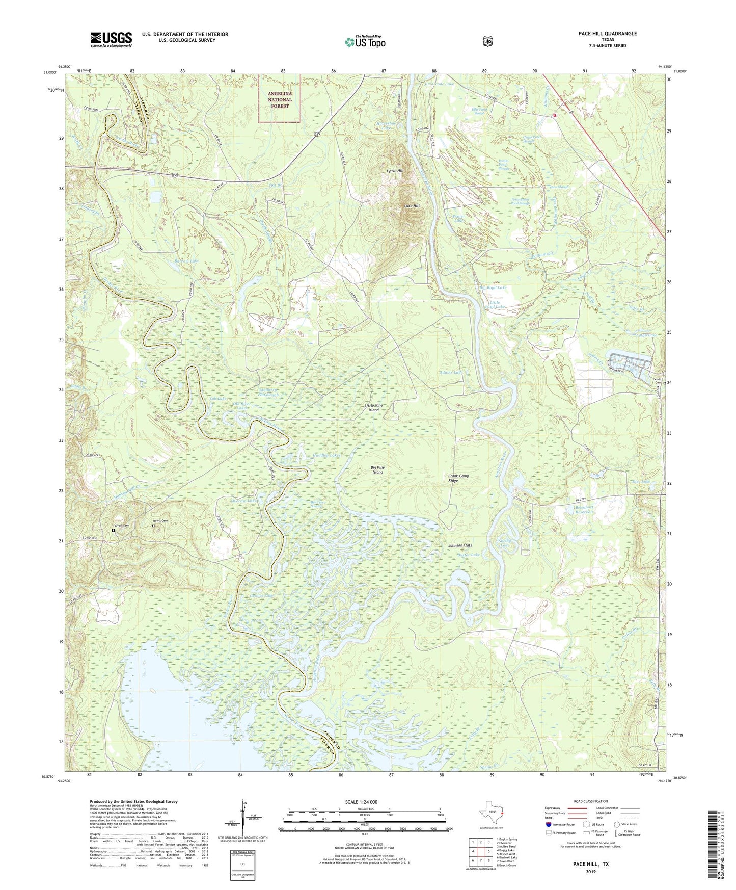
Pace Hill Texas US Topo Map
Couldn't load pickup availability
Also explore the Pace Hill Forest Service Topo of this same quad for updated USFS data
2022 topographic map quadrangle Pace Hill in the state of Texas. Scale: 1:24000. Based on the newly updated USGS 7.5' US Topo map series, this map is in the following counties: Jasper, Tyler. The map contains contour data, water features, and other items you are used to seeing on USGS maps, but also has updated roads and other features. This is the next generation of topographic maps. Printed on high-quality waterproof paper with UV fade-resistant inks.
Quads adjacent to this one:
West: Boggy Lake
Northwest: Boykin Spring
North: Ebenezer
Northeast: McGee Bend
East: Jasper West
Southeast: Beech Grove
South: Town Bluff
Southwest: Birdwell Lake
This map covers the same area as the classic USGS quad with code o30094h2.
Contains the following named places: Adams Lake, Andrew Smyth House, Angelina River, Angelina River Volunteer Fire Department, Barrow Lake, Bee Tree Swamp, Bevelport Reservoir, Bevelport Townsite Historical Monument, Bevilport, Big Boyd Lake, Big Eddy, Big Pine Island, Boggy Branch, Buster Lake, Dallas Branch, Deep Slough, Devils Slough, Dies Lake, Doctor Steven H Everitt Historical Monument, Ellis Pond Slough, Farrell Cemetery, Flat Branch, Fox Landing, Frank Camp Ridge, Grass Pond Slough, Grimes Lake, Gum Slough, Hamilton Lake, Homer, Homer Church, Hopson Mill Creek, Horse Lake, Horseshoe Lake, Huddley Lakes, Indian Creek, Jasper State Fish Hatchery, Jim Goode Lake, Johns Branch, Johnson Flats, Kelly Branch, Lindsey Branch, Lingo Lake, Lingo Lake Dam, Little Boyd Lake, Little Pine Island, Long Lake, Louis Creek, Lynch Hill, May Haw Pond Slough, Moon Lake, Mulberry Flat Slough, Neyland Lake, Old River Lakes, Old River Woodland Trail, Overton Lake, Ox Lot Lake, Pace Hill, Pamplin Creek, Persimmon Pond Slough, Pine Woods, Pool Branch, Potato Pond Slough, Prater Lake, Primrose Slough, Rawls Cemetery, Rocky Creek, Seale Cemetery, Shelby Lake, Smith Ferry, Spring Creek, State Wildlife Scientific Area, TGP 32 Heliport, Tub Lake, Wash Lake, Water Hole, Williams Creek, Yates Branch