MyTopo
Salona Texas US Topo Map
Couldn't load pickup availability
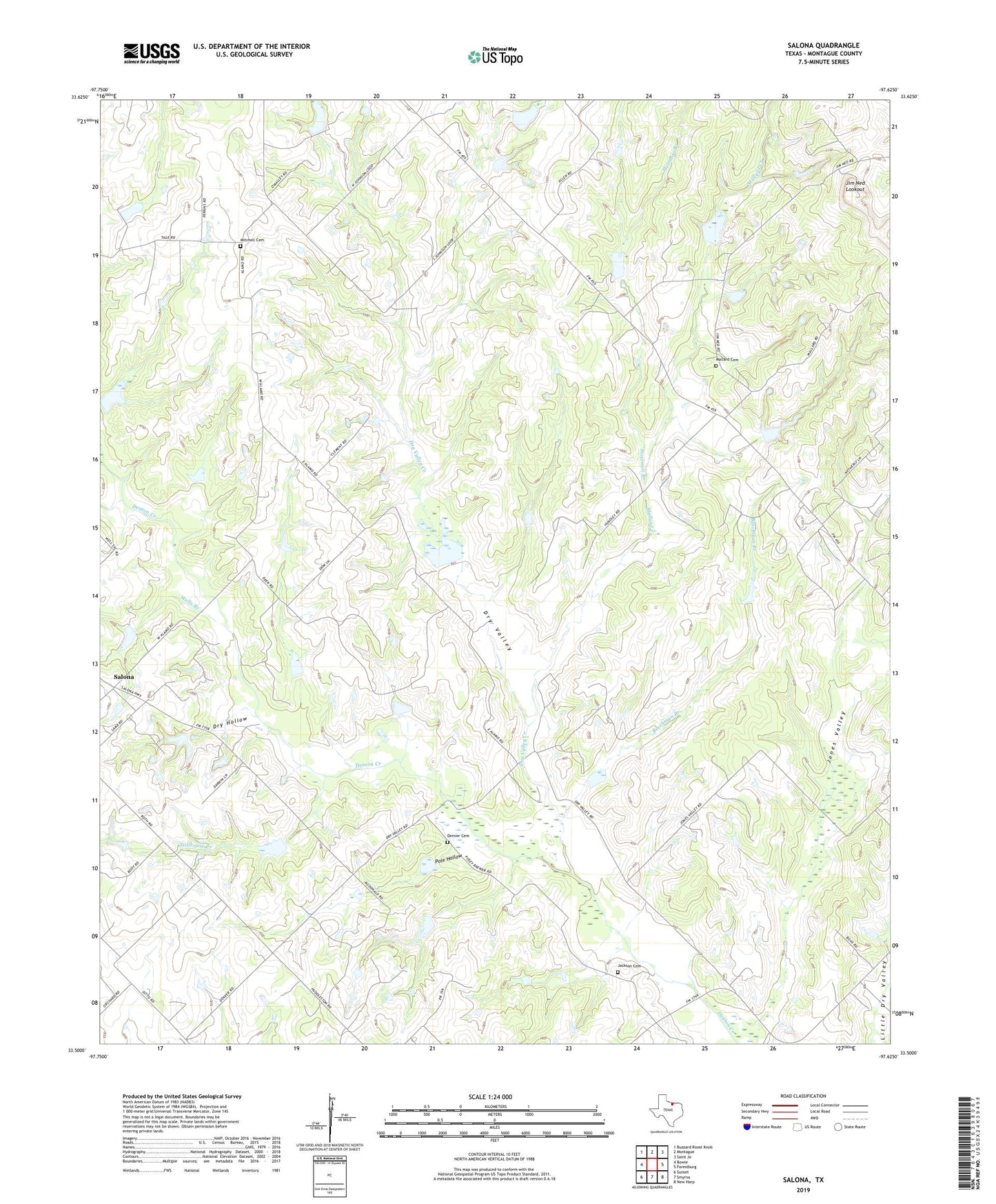
2022 topographic map quadrangle Salona in the state of Texas. Scale: 1:24000. Based on the newly updated USGS 7.5' US Topo map series, this map is in the following counties: Montague. The map contains contour data, water features, and other items you are used to seeing on USGS maps, but also has updated roads and other features. This is the next generation of topographic maps. Printed on high-quality waterproof paper with UV fade-resistant inks.
Quads adjacent to this one:
West: Bowie
Northwest: Buzzard Roost Knob
North: Montague
Northeast: Saint Jo
East: Forestburg
Southeast: New Harp
South: Smyrna
Southwest: Sunset
This map covers the same area as the classic USGS quad with code o33097e6.
Contains the following named places: Aries Caddo Oil Field, Beechman Branch, Denver Cemetery, Denver School, Dry Hollow, Dry Valley, Dry Valley Creek, Jackson Cemetery, Jim Ned Lookout, Jones Valley, Mallard, Mallard Cemetery, Mallard Creek, Mallard Oil Field, Mitchell Cemetery, Montague-Forestburg Division, Pole Hollow, Salona, Sediment Control Structure 2-9 Reservoir, Soil Conservation Service Land Stabilization Structure 3-7, Soil Conservation Service Land Stabilization Structure 3-7 Reservoir, Soil Conservation Service Sediment Control Structure 2-9, Soil Conservation Service Sediment Control Structure 5-3a, Soil Conservation Service Sediment Control Structure 5-3a Reservoir, Soil Conservation Service Sediment Control Structure 8-1, Soil Conservation Service Sediment Control Structure 8-1 Reservoir, Soil Conservation Service Site 1b1 Dam, Soil Conservation Service Site 1b1 Reservoir, Soil Conservation Service Site 1e Dam, Soil Conservation Service Site 1e Reservoir, Soil Conservation Service Site 1j Dam, Soil Conservation Service Site 1j Reservoir, Soil Conservation Service Site 1k Dam, Soil Conservation Service Site 1k Reservoir, Soil Conservation Service Site 2a1 Dam, Soil Conservation Service Site 2a1 Reservoir, Soil Conservation Service Site 2b Dam, Soil Conservation Service Site 2b Reservoir, Soil Conservation Service Site 2c Dam, Soil Conservation Service Site 2c Reservoir, Soil Conservation Service Site 2d Dam, Soil Conservation Service Site 2d Reservoir, Soil Conservation Service Site 2e1 Dam, Soil Conservation Service Site 2e1 Reservoir, Soil Conservation Service Site 2l Dam, Soil Conservation Service Site 2l Reservoir, Soil Conservation Service Site 3 Dam, Soil Conservation Service Site 3 Reservoir, Soil Conservation Service Site 3a Dam, Soil Conservation Service Site 3a Reservoir, Soil Conservation Service Site 3b Dam, Soil Conservation Service Site 3b Reservoir, Soil Conservation Service Site 3c Dam, Soil Conservation Service Site 3c Reservoir, Soil Conservation Service Site 4b Dam, Soil Conservation Service Site 4b Reservoir, Soil Conservation Service Site 4c Dam, Soil Conservation Service Site 4c Reservoir, Soil Conservation Service Site 5 Dam, Soil Conservation Service Site 5 Reservoir, Steelman Branch, Stillhouse Creek, Walker Lake, Walker Lake Dam, Wells Branch