MyTopo
Forestburg Texas US Topo Map
Couldn't load pickup availability
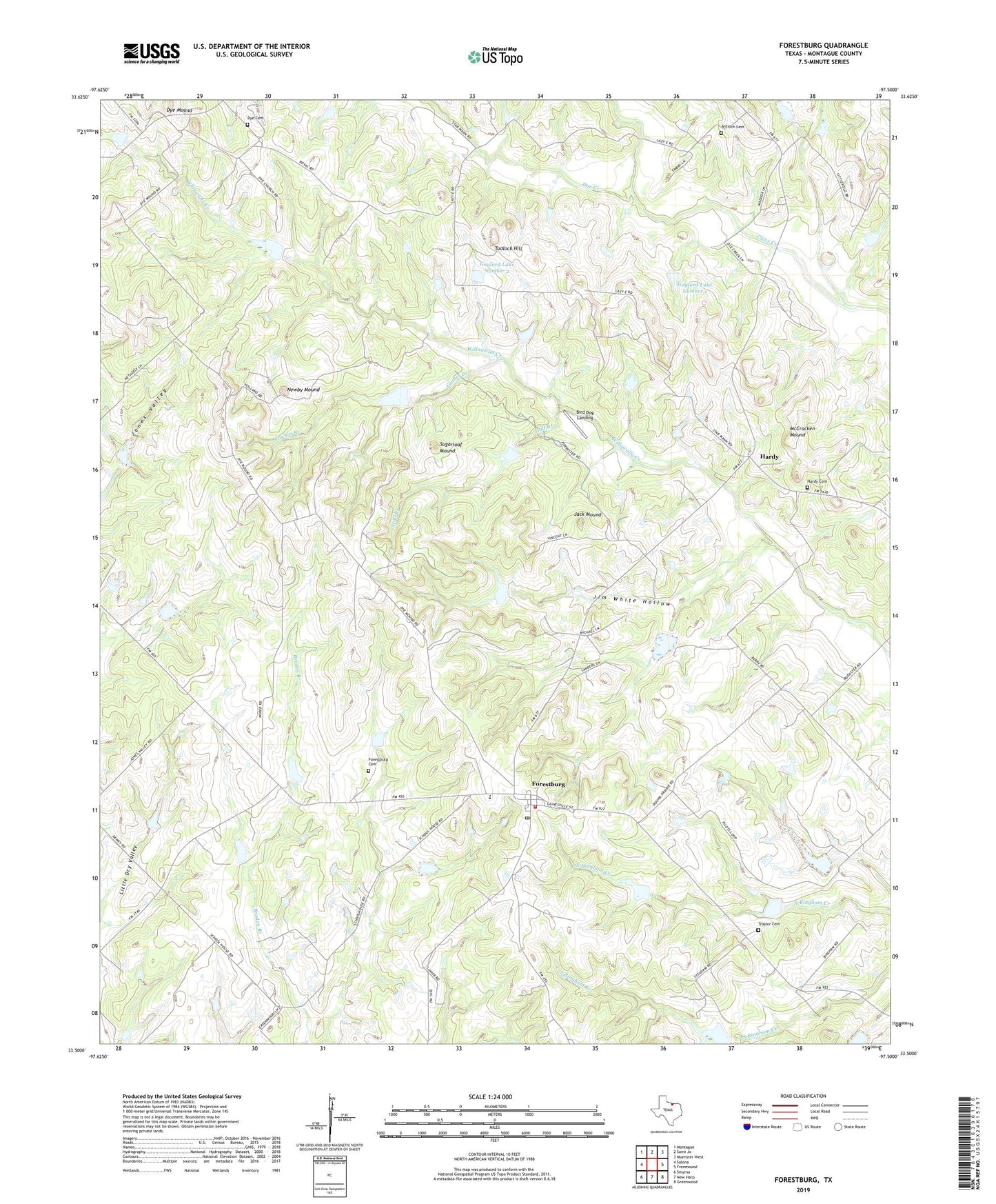
2022 topographic map quadrangle Forestburg in the state of Texas. Scale: 1:24000. Based on the newly updated USGS 7.5' US Topo map series, this map is in the following counties: Montague. The map contains contour data, water features, and other items you are used to seeing on USGS maps, but also has updated roads and other features. This is the next generation of topographic maps. Printed on high-quality waterproof paper with UV fade-resistant inks.
Quads adjacent to this one:
West: Salona
Northwest: Montague
North: Saint Jo
Northeast: Muenster West
East: Freemound
Southeast: Greenwood
South: New Harp
Southwest: Smyrna
This map covers the same area as the classic USGS quad with code o33097e5.
Contains the following named places: Antioch Cemetery, Bird Dog Landing, Dewey Church, Dye, Dye Cemetery, Dye Church, Dye Creek, Dye Mound, Fannin Branch, Forestburg, Forestburg Cemetery, Forestburg Post Office, Forestburg Volunteer Fire Department, Gaylord Lake Number 1, Gaylord Lake Number 1 Dam, Gaylord Lake Number 2, Gaylord Lake Number 2 Dam, Gladys, Hall Branch, Hardy, Hardy Cemetery, Jack Mound, Jim White Hollow, McCracken Mound, Newby Mound, Sediment Control Structure 112 Reservoir, Sediment Control Structure 7-6 Reservoir, Soil Conservation Service Sediment Control Structure 103, Soil Conservation Service Sediment Control Structure 104, Soil Conservation Service Sediment Control Structure 104 Reservoir, Soil Conservation Service Sediment Control Structure 105, Soil Conservation Service Sediment Control Structure 105 Reservoir, Soil Conservation Service Sediment Control Structure 106, Soil Conservation Service Sediment Control Structure 106 Reservoir, Soil Conservation Service Sediment Control Structure 107, Soil Conservation Service Sediment Control Structure 107 Reservoir, Soil Conservation Service Sediment Control Structure 109, Soil Conservation Service Sediment Control Structure 109 Reservoir, Soil Conservation Service Sediment Control Structure 111, Soil Conservation Service Sediment Control Structure 111 Reservoir, Soil Conservation Service Sediment Control Structure 112, Soil Conservation Service Sediment Control Structure 113, Soil Conservation Service Sediment Control Structure 113 Reservoir, Soil Conservation Service Sediment Control Structure 16-1, Soil Conservation Service Sediment Control Structure 16-1 Reservoir, Soil Conservation Service Sediment Control Structure 16-2, Soil Conservation Service Sediment Control Structure 16-2 Reservoir, Soil Conservation Service Sediment Control Structure 7-6, Soil Conservation Service Site 12 Dam, Soil Conservation Service Site 12 Reservoir, Soil Conservation Service Site 13 Dam, Soil Conservation Service Site 13 Reservoir, Soil Conservation Service Site 14 Dam, Soil Conservation Service Site 14 Reservoir, Soil Conservation Service Site 22 Dam, Soil Conservation Service Site 22 Reservoir, Soil Conservation Service Site 23 Dam, Soil Conservation Service Site 23 Reservoir, Soil Conservation Service Site 24 Dam, Soil Conservation Service Site 24 Reservoir, Soil Conservation Service Site 25 Dam, Soil Conservation Service Site 25 Reservoir, Soil Conservation Service Site 26 Dam, Soil Conservation Service Site 26 Reservoir, Soil Conservation Service Site 27 Dam, Soil Conservation Service Site 27 Reservoir, Soil Conservation Service Site 28 Dam, Soil Conservation Service Site 28 Reservoir, Soil Conservation Service Site 29 Dam, Soil Conservation Service Site 29 Reservoir, Soil Conservation Service Site 30 Dam, Soil Conservation Service Site 30 Reservoir, Soil Conservation Service Site 7b Dam, Soil Conservation Service Site 7b Reservoir, Soil Conservation Service Site 7d Dam, Soil Conservation Service Site 7d Reservoir, Soil Conservation Service Site 9a Dam, Soil Conservation Service Site 9a Reservoir, Soil Conservation Service Site 9b Dam, Soil Conservation Service Site 9b Reservoir, Soil Conservation Service Site 9c Dam, Soil Conservation Service Site 9c Reservoir, Soil Conservation Service Site 9d Dam, Soil Conservation Service Site 9d Reservoir, Sugarloaf Mound, Tadlock Hill, Traylor Cemetery, ZIP Code: 76239