MyTopo
Saint George Utah US Topo Map
Couldn't load pickup availability
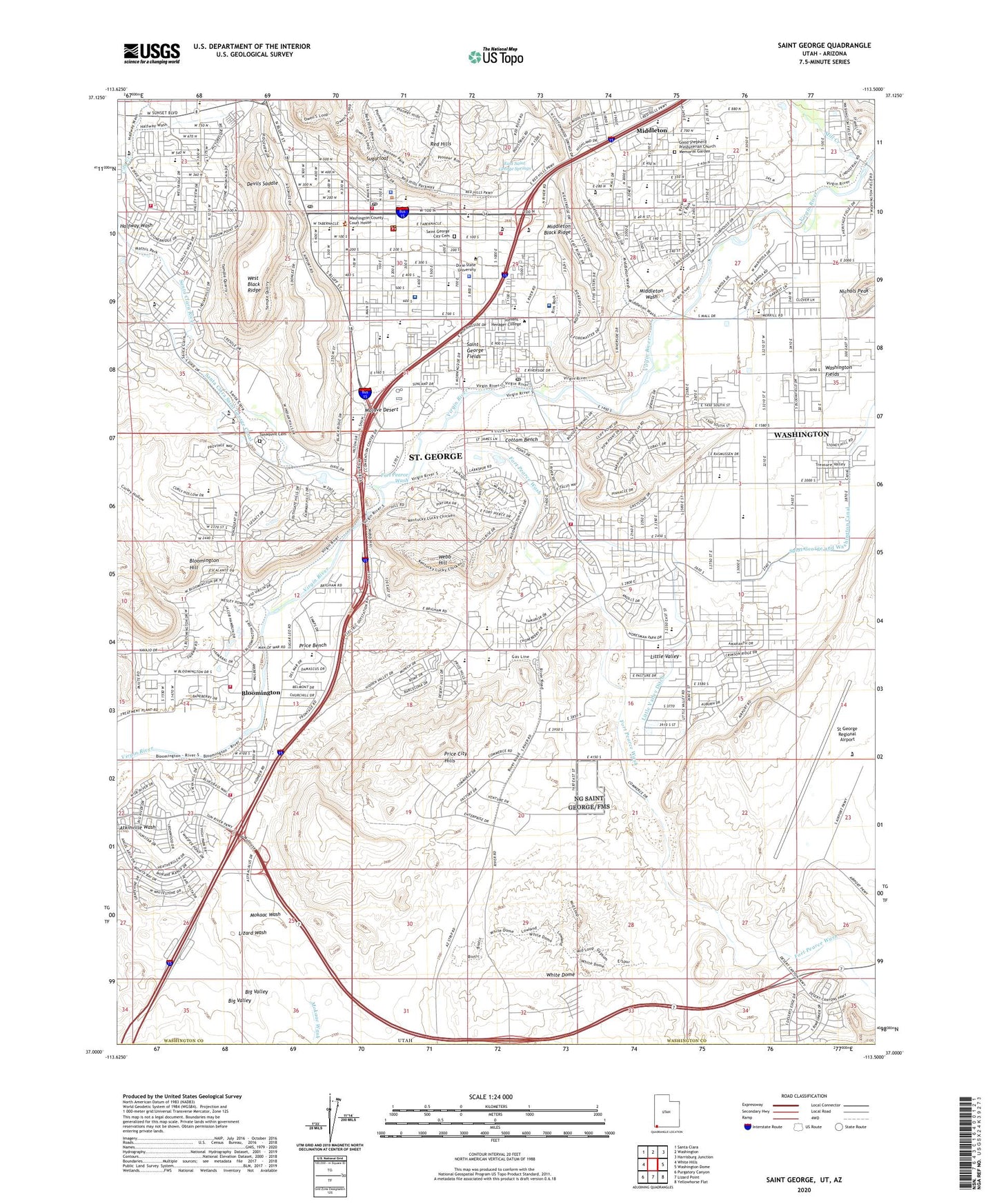
2023 topographic map quadrangle Saint George in the states of Arizona, Utah. Scale: 1:24000. Based on the newly updated USGS 7.5' US Topo map series, this map is in the following counties: Washington, Mohave. The map contains contour data, water features, and other items you are used to seeing on USGS maps, but also has updated roads and other features. This is the next generation of topographic maps. Printed on high-quality waterproof paper with UV fade-resistant inks.
Quads adjacent to this one:
West: White Hills
Northwest: Santa Clara
North: Washington
Northeast: Harrisburg Junction
East: Washington Dome
Southeast: Yellowhorse Flat
South: Lizard Point
Southwest: Purgatory Canyon
This map covers the same area as the classic USGS quad with code o37113a5.
Contains the following named places: Big Valley, Bloomington, Bloomington Elementary School, Bloomington Hill, Bloomington Hills, Brigham Young Winter Home, City Creek, City of Saint George, Community Baptist Church, Cottam Bench, Devils Saddle, Dixie Ambulance Service, Dixie College Police Department, Dixie High School, Dixie Middle School, Dixie Regional Medical Center, Dixie Regional Medical Center River Road Campus, Dixie State University, Downtown Saint George Post Office, East City Center, East Elementary School, East Saint George Springs, First Southern Baptist Church, Fort Pearce Wash, Gold Cross Ambulance, Gold Cross Ambulance Saint George Headquarters, Good Shepherd Presbyterian Church Memorial Garden, Halfway Wash, Hillside Palms RV Park, KDXU-AM (Saint George), Kemp Korner Shopping Center, KRDC-FM (St George), KZEZ-FM (St George), Little Valley, Little Valley Ditch, Lizard Wash, Middleton, Middleton Wash, Mill Creek, Millcreek High School, Mokaac Wash, Nichols Peak, Panorama Elementary School, Pine View High School, Pine View Middle School, Price Bench, Price Bench Ditch, Price City, Price City Hills, Red Hills, Red Hills Shopping Plaza, Saint George, Saint George Catholic Church, Saint George City Cemetery, Saint George Fields, Saint George Fire Department Station 1, Saint George Fire Department Station 2, Saint George Fire Department Station 3, Saint George Fire Department Station 4, Saint George Fire Department Station 5, Saint George Fire Department Station 6, Saint George Fire Department Station 8, Saint George Municipal Airport, Saint George Municipal Airport Lifeflight, Saint George Police Department, Saint George Post Office, Saint George Post Office Hurst Station, Saint George RV Campground, Saint George Valley Lateral, Saint George West School, Santa Clara River, Santa Clara Saint George Canal, Settlers RV Park, Skyline Shopping Center, Southern Trailer Park, St George Regional Airport, Sugarloaf, Sunset Elementary School, Sunshine Square, Temple View RV Resort, The Church of Jesus Christ of Latter Day Saints, Tonaquint Cemetery, Toniquint, Trinity Lutheran Church of Southern Utah, Twin Lakes RV Park, United States Bureau of Indian Affairs Paiute Field Office, United States Forest Service Fire Station - Saint George Office, Valley View Trailer Park, Washington Fields, Webb Hill, West Black Ridge, White Dome, Woodward School, ZIP Code: 84790