MyTopo
Bellows Falls Vermont US Topo Map
Couldn't load pickup availability
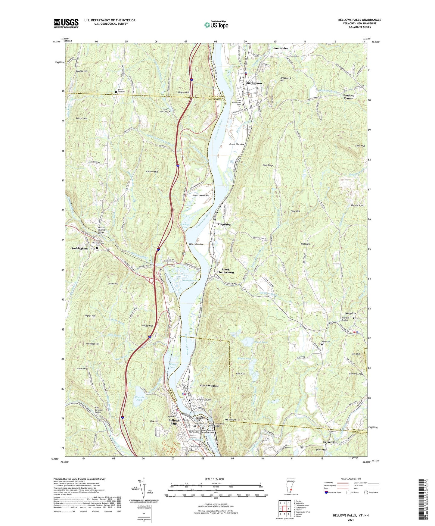
2024 topographic map quadrangle Bellows Falls in the states of New Hampshire, Vermont. Scale: 1:24000. Based on the newly updated USGS 7.5' US Topo map series, this map is in the following counties: Windham, Sullivan, Cheshire, Windsor. The map contains contour data, water features, and other items you are used to seeing on USGS maps, but also has updated roads and other features. This is the next generation of topographic maps. Printed on high-quality waterproof paper with UV fade-resistant inks.
Quads adjacent to this one:
West: Saxtons River
Northwest: Chester
North: Springfield
Northeast: Claremont South
East: Alstead
Southeast: Gilsum
South: Walpole
Southwest: Westminster West
This map covers the same area as the classic USGS quad with code o43072b4.
Contains the following named places: Adams Grist Mill, Allbees Cove, Balls Hill, Bates Mill Pond Dam, Bellows Falls, Bellows Falls Canal, Bellows Falls Dam, Bellows Falls Downtown Historic District, Bellows Falls Fire Department, Bellows Falls Historical Society Museum, Bellows Falls Middle School, Bellows Falls Opera House, Bellows Falls Police Department, Bellows Falls Post Office, Bellows Falls Village Forest, Benware Brook, Boston and Maine Railroad Tunnel, Breakneck Hill, Central Elementary School, Charlestown, Charlestown Census Designated Place, Charlestown Fire Department, Charlestown Main Street Historic District, Charlestown Middle School, Charlestown Police Department, Charlestown Post Office, Charlestown Primary School, Charlestown Town Hall, Cherry Hill Elementary School, Clay Brook, Clay Brook Dam, Clay Brook Reservoir, Cobble Hill, Coburn Hill, Cold Springs, Colley Hill, Commissary Brook, Condon Cor, Connecticut River Reservoir, Connecticut River State Park, Darby Brook, Darby Hill, Dickerson Brook, Divoll Brook, Drew Mountain, Drewsville, Drewsville Village Green, Ellis Brook, Fall Mountain, Fall Mountain Regional High School, Farr Brook, First Baptist Church, First Connecticut River Bridge, Fish Ladder and New England Power Company Information Center, Glovers Ledge, Gravel Brook, Great Brook, Great Falls, Great Falls Regional Chamber of Commerce, Great Meadow, Hackett Brook, Hall Covered Bridge, Halladay Brook, Hemlock Center, Hemlock Hill, Herricks Cove, Hogan Hill, Hyde Hill, Hyde Hill Brook, Immanuel Cemetery, Immanuel Episcopal Church, Independent Baptist Church of Christ School, Jabes Hackett Brook, Jones Hill, Langdon, Langdon Congregational Church, Langdon Fire and Rescue, Langdon Meeting House, Langdon Police Department, Langdon Town Hall, Lefevre Ambulance, Little Brook, Little Commissary Brook, Locke Brook, Lover Meadow, Marks Brook, Meadow Brook, Middle Pond, Minards Pond, Minards Pond Dam, Moore and Thompson Paper Mill, Mount Kilburn, Mountain Brook, North Pond, North Walpole, North Walpole Census Designated Place, North Walpole Elementary School, North Walpole Fire Department, North Walpole Police Dept, Noyes Brook, Oak Hill, Oak Ridge, O'Brien Brook, Old Fire House, Oliver Lovell Cemetery, Page Hill, Paradise Hill, Parker Hill, Parker Hill Cemetery, Polish American Club, Prentiss Bridge, Restland Cemetery, Robinson Brook, Rockingham, Rockingham Free Public Library, Rockingham Meeting House Cemetery, Rockingham Meeting-House, Rockingham Town Hall, Roundys Cove, Saint Catherines Cemetery, Saint Lukes Episcopal Church, Saint Peters Episcopal Church, Sams Hill, Sarah Porter School, Signal Hill, Silsby Free Public Library, Snumshire, South Charlestown, South Parish Unitarian Church, The Community School, The Health Center at Bellows Falls, The Square, The Stairs, Tory Hill, Town of Charlestown, Town of Langdon, Trapshire, United Church of Bellows Falls, Upper Meadows, Upper Meadows Brook, Village of Bellows Falls, Webb Brook, West Cemetery, Wiley Hill Brook, Williams River, Windham Northeast Supervisory Union, Worrall Covered Bridge, ZIP Codes: 03603, 03604, 03609, 05101