MyTopo
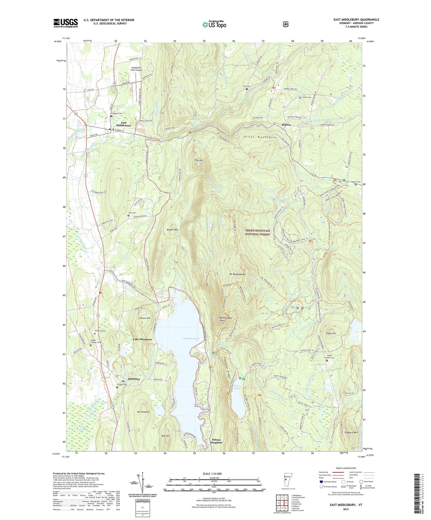
East Middlebury Vermont US Topo Map
Couldn't load pickup availability
2021 topographic map quadrangle East Middlebury in the state of Vermont. Scale: 1:24000. Based on the newly updated USGS 7.5' US Topo map series, this map is in the following counties: Addison. The map contains contour data, water features, and other items you are used to seeing on USGS maps, but also has updated roads and other features. This is the next generation of topographic maps. Printed on high-quality waterproof paper with UV fade-resistant inks.
Quads adjacent to this one:
West: Cornwall
Northwest: Middlebury
North: South Mountain
Northeast: Lincoln
East: Bread Loaf
Southeast: Mount Carmel
South: Brandon
Southwest: Sudbury
Contains the following named places: Barnard Brook, Beaver Brook, Blueberry Hill Winter Sports Area, Branbury State Park, Brandy Brook, Bryant Mountain, Camp Brebeuf for Boys, Camp Charidan, Camp Keewaydin, Chandler Ridge, Cooks Cemetery, Dragon Brook, Dutton Brook, East Middlebury, East Middlebury Census Designated Place, East Middlebury Post Office, Falls of Lana, Falls of Lana Picnic Grounds, Falls of Lana Trail, Fire Brook, Galvin Cemetery, Gea Cemetery, Gee Cemetery, Gonya Brook, Goshen Brook, Goshen Dam, Hale Brook, Hogback Mountain, Keewaydin Trail, Lake Dumore Kampersville, Lake Dunmore, Lake Dunmore Dam, Lake Dunmore School, Middle Branch Middlebury River, Middlebury State Airport, Middlebury Volunteer Fire Department - Station 2, Moosalamoo Campground, Mount Moosalamoo, Mount Moosalamoo Campground Trail, Mount Moosalamoo Trail, Mount Pleasant, Nabby Cooper Cemetery, Nature Trail, North Branch Middlebury River, North Branch Sucker Brook, North Branch Trail, North Goshen Cemetery, Oak Hill, Oak Ridge Trail, Pine Hill, Plain School, Prospect Cemetery, Rattlesnake Point, Rice Cemetery, Riley Bostwick Wildlife Management Area, Ripton, Ripton Elementary School, Ripton Fire Department, Robert Frost Interpretive Trail, Robert Frost Wayside, Salisbury, Salisbury Cemetery, Salisbury Community School, Salisbury Congregational Church, Salisbury Hatchery, Salisbury Municipal Forest, Salisbury Post Office, Salisbury Volunteer Department, Sarah Partridge Library, Satans Kingdom, Silver Lake, Silver Lake Camp and Picnic Grounds, Silver Lake Dam, Silver Lake Recreation Area, Silver Lake Trail, Silver Towers Camp, South Branch Middlebury River, Sparks Brook, Stewart Dam, Sucker Brook, Sucker Brook Dam, Sucker Brook Reservoir, Sugar Hill, Sugar Hill Dam, Sugar Hill Reservoir, Sunset Hill, Town of Salisbury, United State Forest Service Silver Lake Campground, United States Forest Service Mount Moosalamoo Campground, Valley Bible Church, Village Cemetery, Voters Brook, ZIP Codes: 05740, 05769