MyTopo
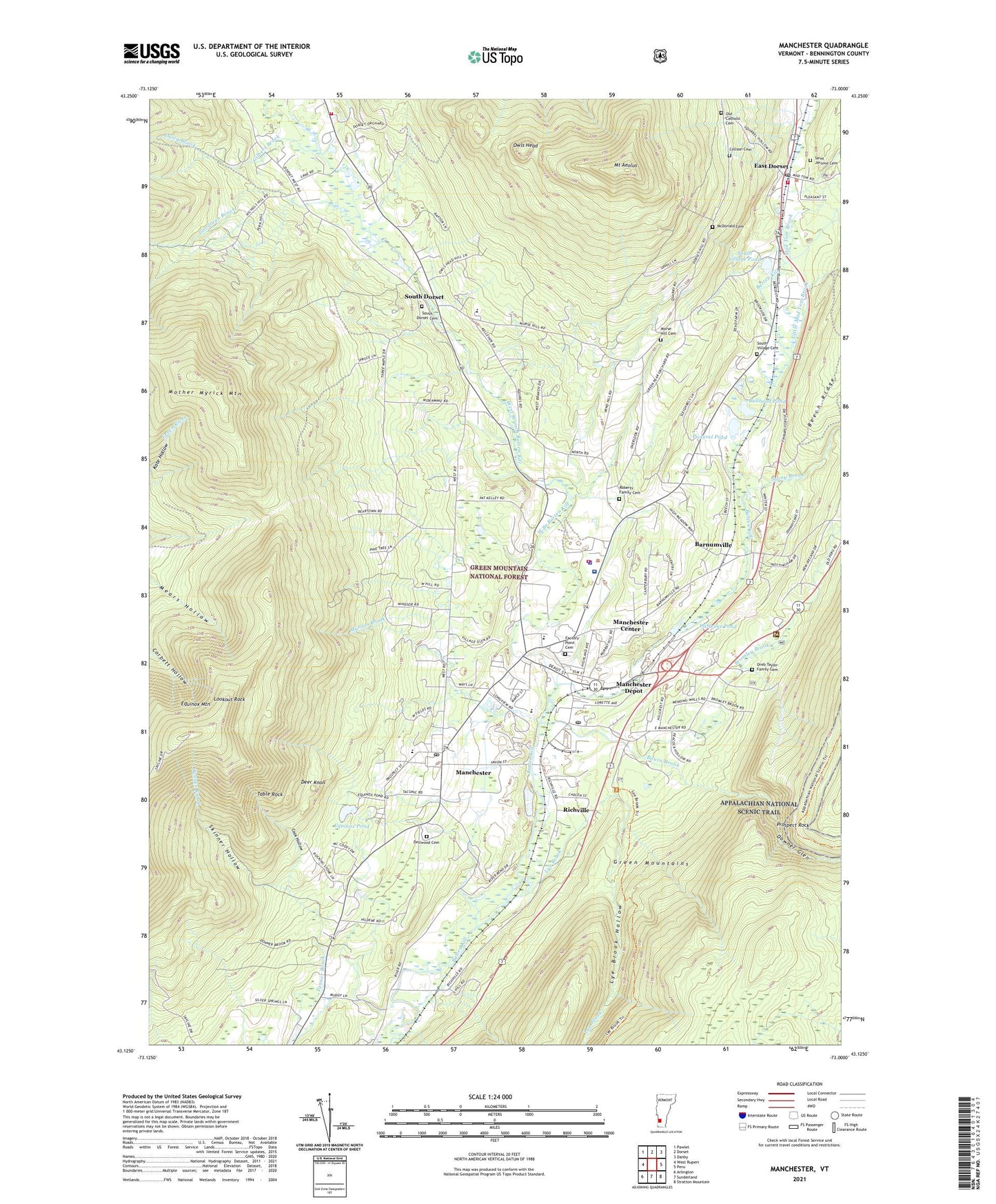
Manchester Vermont US Topo Map
Couldn't load pickup availability
Also explore the Manchester Forest Service Topo of this same quad for updated USFS data
2024 topographic map quadrangle Manchester in the state of Vermont. Scale: 1:24000. Based on the newly updated USGS 7.5' US Topo map series, this map is in the following counties: Bennington. The map contains contour data, water features, and other items you are used to seeing on USGS maps, but also has updated roads and other features. This is the next generation of topographic maps. Printed on high-quality waterproof paper with UV fade-resistant inks.
Quads adjacent to this one:
West: West Rupert
Northwest: Pawlet
North: Dorset
Northeast: Danby
East: Peru
Southeast: Stratton Mountain
South: Sunderland
Southwest: Arlington
This map covers the same area as the classic USGS quad with code o43073b1.
Contains the following named places: Barnumville, Battenkill Plaza Shopping Center, Bourn Brook, Bourne Brook, Bromley Brook, Bromley Brook School, Bullhead Pond, Burr and Burton Academy, Collson Cemetery, Conversion of Saint Paul Catholic Church, Cook Hollow, Daley Brook, Dana L Thompson Memorial Park, Deer Knoll, Dellwood Cemetery, Dorset Fire District 1, Dorset School, Dorset Town Hall, Downer Glen, Dufresne Pond, Dufresne Pond Dam, East Dorset, East Dorset Census Designated Place, East Dorset Congregational Church, East Dorset Fire District, East Dorset Post Office, Ekwanok Country Club, Equinox House, Equinox House Historic District, Equinox Landing Field, Equinox Mountain, Equinox Pond, Equinox Square Shopping Center, Factory Point Cemetery, First Baptist Church, First Congregational Church, Gilbert Brook, Goodman Brook, Grange Hall, Haines Manor, Hildene, Hildene Ski Touring Center, Hildene Winter Sports Area, Israel Congregational Synagogue, Kent Neighborhood Historic District, Little Mad Tom Brook, Lookout Rock, Lye Brook, Lye Brook Hollow, Mad Tom Brook, Manchester, Manchester Area Chamber of Commerce, Manchester Center, Manchester Center Census Designated Place, Manchester Center Post Office, Manchester Center Town Hall, Manchester Commons Shopping Center, Manchester Depot, Manchester Elementary / Middle School, Manchester Fire Department, Manchester Golf Course, Manchester Post Office, Manchester Rescue Squad, Manchester Shopping Center, Manchester Square Shopping Center, Manchester Town Hall, Manchester Village Historic District, Manchester Visitor Information Center, Maple Street School, Mark Skinner Library, McDonald Cemetery, Morse Hill Cemetery, Mother Myrick Mountain, Mount Aeolus, Mount Laurel School, Mountain View Estates, Munson Brook, Northshire Baptist Fellowship, Northside Christian Academy, Northside Medical Center, Old Catholic Cemetery, Oreb Taylor Family Cemetery, Ormsby Hill School, Owls Head, Owls Head Municipal Forest, Pickerel Pond, Prospect Rock, Richville, Roberts Family Cemetery, Saint Jerome Cemetery, Saint Jeromes Church, Saint Jeromes Episcopal Church, Skinner Hollow, South Dorset, South Dorset Cemetery, South Dorset Post Office, South Village Cemetery, South Village Pond, Southern Vermont Art Center, Southwestern Vermont Health Care Medical Center Northshire Campus, Stony Brook, Table Rock, The American Museum of Fly Fishing, The American Museum of Fly Fishing Library, Town of Manchester, Village of Manchester, WEQX-FM (Manchester), West Branch Batten Kill, WJAN-FM (Sunderland), Zion Episcopal Church, ZIP Codes: 05253, 05254, 05255