MyTopo
Caney Ridge Virginia US Topo Map
Couldn't load pickup availability
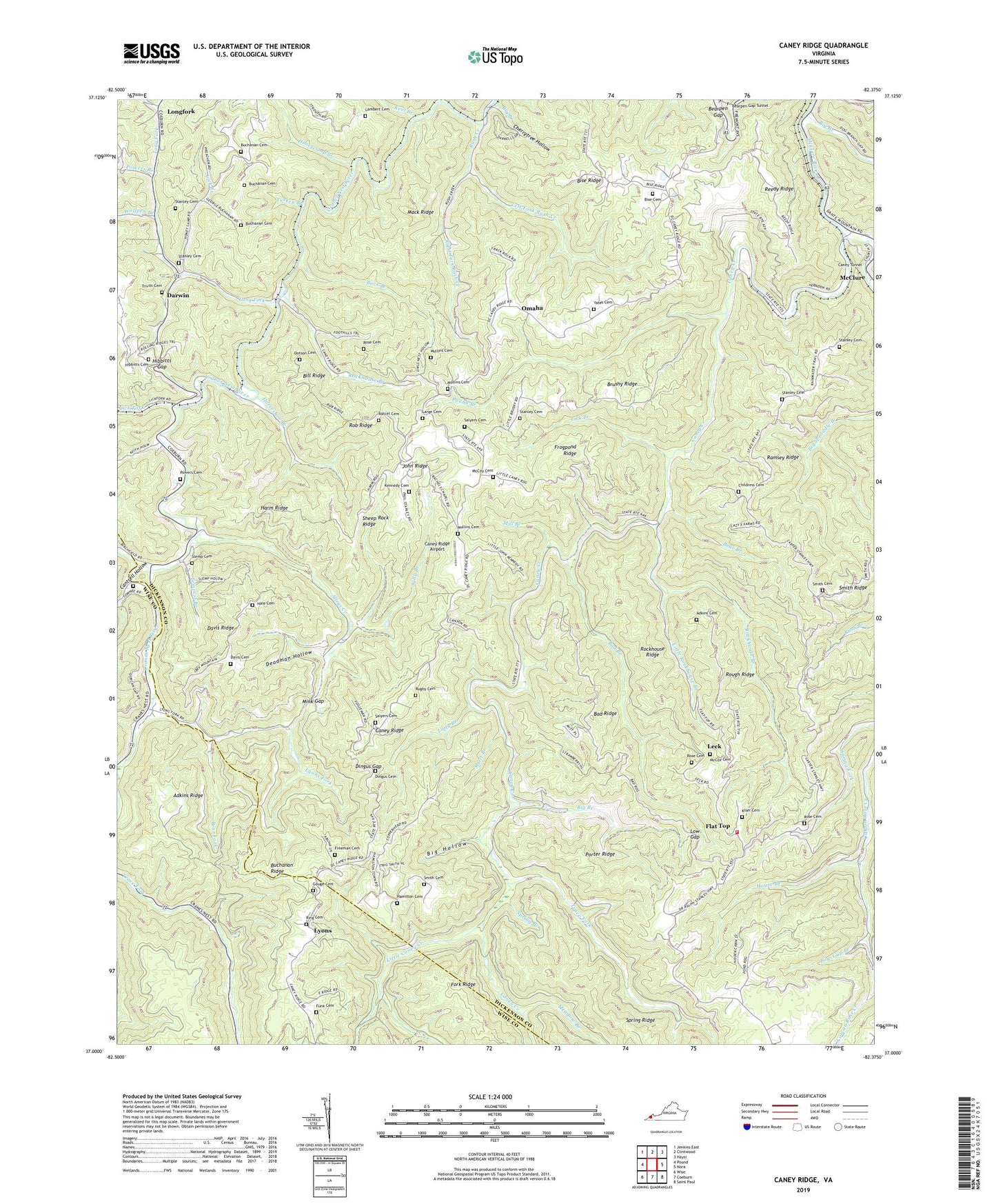
2022 topographic map quadrangle Caney Ridge in the state of Virginia. Scale: 1:24000. Based on the newly updated USGS 7.5' US Topo map series, this map is in the following counties: Dickenson, Wise. The map contains contour data, water features, and other items you are used to seeing on USGS maps, but also has updated roads and other features. This is the next generation of topographic maps. Printed on high-quality waterproof paper with UV fade-resistant inks.
Quads adjacent to this one:
West: Pound
Northwest: Jenkins East
North: Clintwood
Northeast: Haysi
East: Nora
Southeast: Saint Paul
South: Coeburn
Southwest: Wise
This map covers the same area as the classic USGS quad with code o37082a4.
Contains the following named places: Adkins Cemetery, Adkins Ridge, Alka, Alleys Creek, Bad Branch, Bad Ridge, Bad Ridge School, Bear Branch, Bear Fork, Bearpen Gap, Big Branch, Big Hollow, Big Oak School, Bill Ridge, Birchfield Creek, Bise Cemetery, Bise Ridge, Bise School, Brushy Ridge, Buchanan Cemetery, Buchanan Ridge, Buck Branch, Caney Creek, Caney Fork Church, Caney Ridge, Caney Ridge Airport, Caney Tunnel, Cantrell Hollow, Cherrytree Hollow, Childress Cemetery, Clintwood Volunteer Fire Department Station 2, Crabtree Fork, Darwin, Davis Cemetery, Davis Chapel, Davis Ridge, Deadman Hollow, Dingus Cemetery, Dingus Gap, Dotson Cemetery, Flat Top, Foraker, Freeman Cemetery, Fremont Church, Frogpond Ridge, Funk Cemetery, Gouge Cemetery, Hale Cemetery, Hamilton Cemetery, Harm Ridge, Hibbitts Cemetery, Hibbitts Gap, Honeycamp Branch, Horseshoe Branch, House Branch, Hutchinson School, Ibex, John Ridge, Keel Branch, Kenady District, Kenady School, Kennedy Cemetery, Kiser Cemetery, Lambert Cemetery, Large Cemetery, Lebanon Church, Leck, Left Fork Rush Creek, Lick Branch, Lick Fork, Lick Fork Church, Little Caney Creek, Little Rockhouse Branch, Long Branch, Long Fork, Long Fork Church, Longfork, Low Gap, Low Gap Branch, Lyons, Lyons Fork, Mack Ridge, Maple Grove Church, McClure, McCoy Cemetery, Meadow Branch, Mill Branch, Millard Peuther Chapel, Mink Gap, Mullins Cemetery, Omaha, Pine Grove Church, Pippin Chapel, Porter Ridge, Pound Branch, Powers Branch, Powers Cemetery, Rachel Chapel, Rachel Chapel School, Ramsey, Ramsey Ridge, Ratliff Cemetery, Reedy Ridge, Right Fork Rush Creek, Ring Cemetery, Rob Ridge, Roberson Cemetery, Rockhouse Branch, Rockhouse Ridge, Rose Cemetery, Rose Hill School, Rough Ridge, Rugby Cemetery, Rugby Church, Rugby School, Rush Creek, Sally Branch, Salyers Cemetery, Sheep Rock Ridge, Short Branch, Slemp Cemetery, Smith Cemetery, Smith Corners, Smith Ridge, Spring Branch, Spring Ridge, Stanley Cemetery, Sweet Home Church, Tempest Branch, Trace Fork, Trace Fork School, Trivitt Cemetery, Turkey Branch, Wolfpen Branch, Yates Cemetery, Yates Chapel, Yates School, ZIP Code: 24269