MyTopo
Haysi Virginia US Topo Map
Couldn't load pickup availability
Also explore the Haysi Forest Service Topo of this same quad for updated USFS data
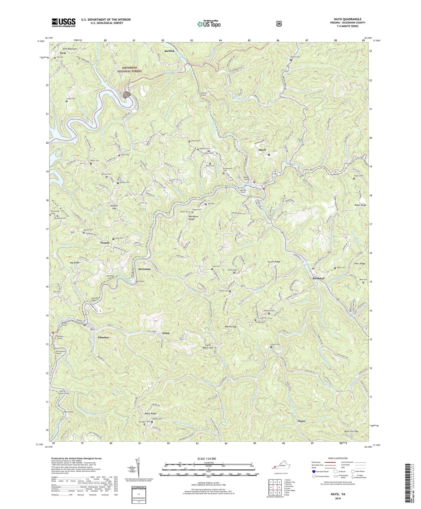
2022 topographic map quadrangle Haysi in the state of Virginia. Scale: 1:24000. Based on the newly updated USGS 7.5' US Topo map series, this map is in the following counties: Dickenson. The map contains contour data, water features, and other items you are used to seeing on USGS maps, but also has updated roads and other features. This is the next generation of topographic maps. Printed on high-quality waterproof paper with UV fade-resistant inks.
Quads adjacent to this one:
West: Clintwood
Northwest: Hellier
North: Elkhorn City
Northeast: Harman
East: Prater
Southeast: Duty
South: Nora
Southwest: Caney Ridge
This map covers the same area as the classic USGS quad with code o37082b3.
Contains the following named places: Arlington Cemetery, Backbone Ridge, Bartlick, Bartlick Lookout Tower, Bartlick School, Barts Lick Creek, Basin Branch, Beech Branch, Big Branch, Big Ridge Presbyterian Church, Birchleaf, Birchleaf Post Office, Blacklog Branch, Bowling Branch, Buck Branch, Burnt Field School, Byers Cemetery, Camp Branch, Cane Branch, Carve Beech Gap, Clinchco, Clinchco Elementary School, Clinchco Police Department, Clinchco Post Office, Clinchco Volunteer Fire Department, Colley Cemetery, Counts, Counts Cemetery, Counts Church, Counts School, Crooked Branch, Damon Branch, Davis Cemetery, Davis School, Deel Cemetery, Delano, Dickenson County, Dickenson County Career Center, Doe Branch, Dog Branch, Dog Branch School, Duty Branch, Edwards Cemetery, Edwards Chapel, Faith Bible Church, Farmer Cemetery, Fay Cemetery, Fay Hollow, Flemming Cemetery, Fryingpan Creek, Gay Branch, Goff Tunnel, Hay Cemetery, Haysi, Haysi High School, Haysi Police Department, Haysi Post Office, Haysi Volunteer Fire Department, Haysi Volunteer Rescue Squad, Hewitt Cemetery, Hewitt Tunnel, Hill School, Hills Mill Tunnel, House Fork, Hughes Branch, Hurricane Branch, John W Flannagan Dam, Junction Boat Ramp, Laurel Branch, Lazarus Branch, Left Fork Lick Creek, Lick Creek, Lick Creek Church, Linn Branch, Little Beech Branch, Little Lick Creek, Lower Cane Branch, Lower Rakes Branch, Lower Twin Boat Ramp, Lower Twin Branch, Mart, Martha Gap, McClure River, McClure Tunnel, McCown Cemetery, Mill Creek, Mill Creek Church, Mill Creek School, Mount Olive Baptist Church, Mount Olivet Church, Mullins Cemetery, Music Cemetery, Musick Cemetery, Musick School, Nancy, Nealy Ridge Lookout Tower, Newberry Cemetery, Nut Branch, O'Quin Cemetery, Owens Cemetery, Perkins Tunnel, Persimmon Branch, Pettit Tunnel, Pound River, Prater School, Presley Branch, Price Cemetery, Puckett Cemetery, Puckett Gap, Red Ridge Tunnel, Rinehart Tunnel, Road Branch, Rock Lick Gap, Rocky Branch, Russell Prater Creek, Russell Tunnel, Sand Lick Branch, Sand Lick Church, Sand Lick District, Sandlick Elementary School, Short Branch, Short Branch Tunnel, Shumac Church, Skeet Rock Branch, Skillet Branch, Slate Branch, Southwest Virginia Regional Jail Authority - Haysi Facility, Splashdam, Splashdam Church, Spring Branch, Squirrel Camp Branch, Squirrel Camp Tunnel, Steinman, Stephen Cemetery, Stephens Fork, Sugar Branch, Sunderland Cemetery, Sykes Mill Tunnel, Tarpon, Tarpon Freewill Baptist Church, Tenso, Tilda Anderson Branch, Tilda Anderson School, Tivis, Tivis Branch, Tivis School, Toms Fork, Town of Clinchco, Town of Haysi, Turkey Branch, Turner Cemetery, Turner Ridge, Turner School, Twin Branch School, Union Church, Upper Cane Branch, Upper Hurricane Branch, Upper Twin Branch, Viers Cemetery, WDIC-FM (Clinchco), White Branch, Willis Cemetery, Willis Chapel, Wolfpen Branch, Zekes Branch, ZIP Codes: 24226, 24256