
MyTopo
Clintwood Virginia US Topo Map
Couldn't load pickup availability
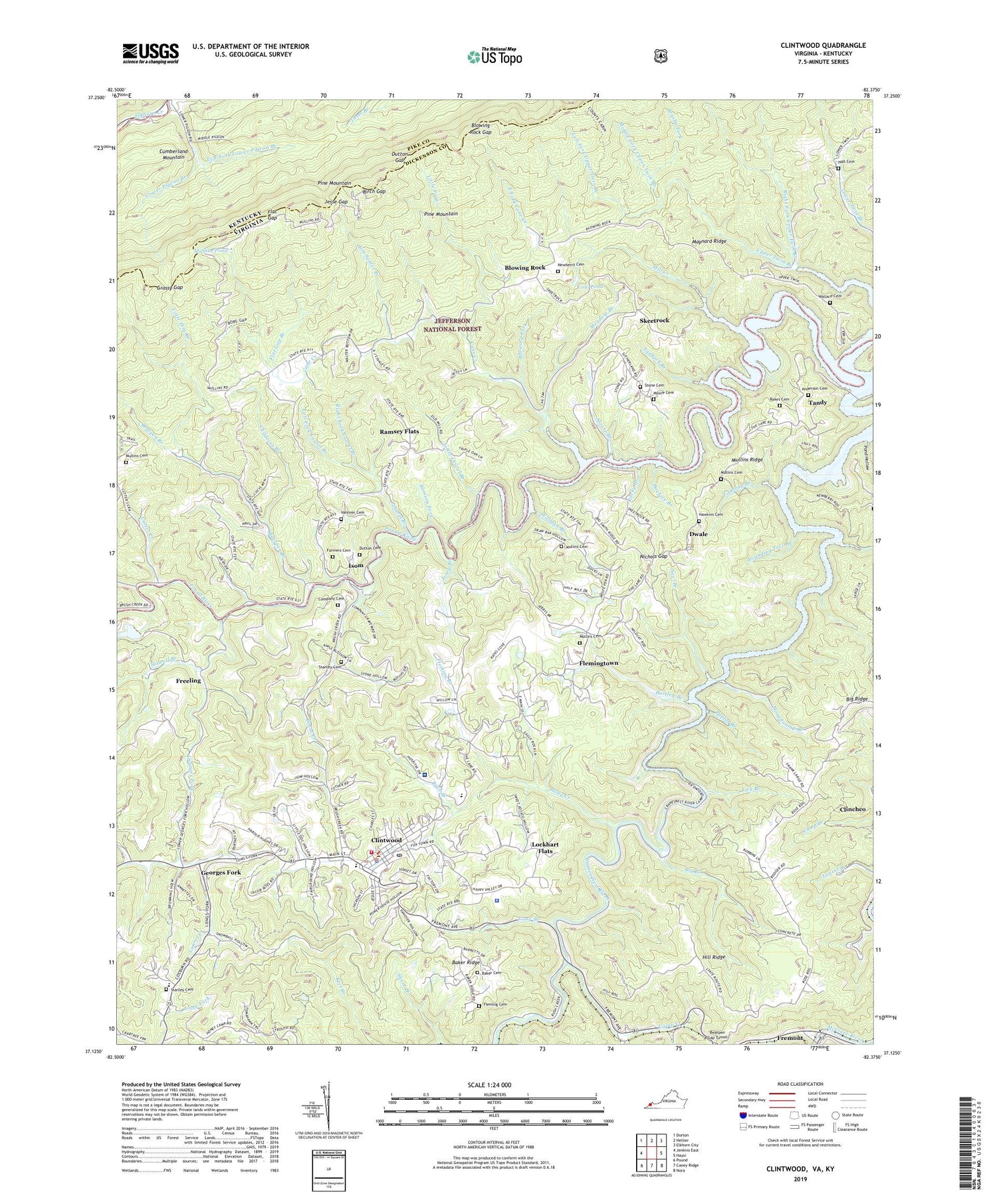
2019 topographic map quadrangle Clintwood in the states of Virginia, Kentucky. Scale: 1:24000. Based on the newly updated USGS 7.5' US Topo map series, this map is in the following counties: Dickenson, Pike. The map contains contour data, water features, and other items you are used to seeing on USGS maps, but also has updated roads and other features. This is the next generation of topographic maps. Printed on high-quality waterproof paper with UV fade-resistant inks.
Quads adjacent to this one:
West: Jenkins East
Northwest: Dorton
North: Hellier
Northeast: Elkhorn City
East: Haysi
Southeast: Nora
South: Caney Ridge
Southwest: Pound
Contains the following named places: Anderson Cemetery, Anderson School, Baker Cemetery, Baker Ridge, Bartley Branch, Bearpen Branch, Bearpen Gap Tunnel, Big Branch, Big Ridge, Birch Gap, Blowing Fork, Blowing Rock, Blowing Rock Gap, Brush Creek, Brush Creek School, Brushy Fork, Camp Creek, Cane Creek, Childress Branch, Clintwood, Clintwood Bible Church, Clintwood Elementary School, Clintwood High School, Clintwood Police Department, Clintwood Post Office, Clintwood Volunteer Fire Department Station 1, Clintwood Volunteer Rescue Squad, Company Cemetery, Cow Pond, Cranes Nest River, Cumberland Church, Cutter Creek, Dickenson Community Hospital, Dickenson County Ambulance Service, Dickenson County Courthouse, Dickenson County Sheriff's Office, Doeface Branch, Dutton Cemetery, Dutton Gap, Dwale, East Fork Cane Creek, Fairview School, Farmers Cemetery, Fishtrap Branch, Flat Gap, Flat Gap Branch, Fleming Branch, Fleming Cemetery, Flemingtown, Freeling, Fremont, Georges Fork, Grassy Gap, Hall Cemetery, Hawkins Cemetery, Hill Ridge, Hill Ridge Church, Holly Creek, Honey Camp, Honeycamp Branch, Howell Branch, Huckleberry, Isom, Jerry Branch, Jesse Gap, Jim Senter Branch, John W. Flannagan Reservoir, Keel Lookout Tower, Kerr School, Large School, Laurel Branch, Laurel Creek, Left Fork Laurel Branch, Left Fork Lower Pigeon Branch, Left Fork Upper Twin Branch, Lick Branch, Little Fork, Little Laurel Branch, Little Pine Branch, Lockhart Flats, Long Branch, Longs Fork Elementary School, Lower Pigeon Branch, Maynard Ridge, Meadow Branch, Middle Fork Upper Twin Branch, Mill Creek, Millard, Moore Branch, Moore Cemetery, Mountain View School, Mullins Cemetery, Mullins Pond, Mullins Ridge, Neel Branch, Newberry Cemetery, Nicewonder Dam, Nichols Gap, Nichols Gap School, Pine Branch, Pine Creek, Pond Hollow, Poplar Branch, Pound River Church, Pounding Tree Branch, Rainy Flat School, Rakes Cemetery, Ralph Stanley Museum and Traditional Mountain Music Center, Ramsey Flats, Ramsey Fork, Right Fork Laurel Branch, Right Fork Upper Twin Branch, Rock Branch, Rocky Branch, Rose Hill Church, Skeetrock, Skeetrock Church, Solid Rock Church, Stanley Cemetery, Star Branch, Stone Cemetery, Stonewall School, Tanbark Branch, Tandy, Tarpon Branch, Town of Clintwood, Trivette School, Valley View Church, Vanover Cemetery, Wallace Cemetery, WDIC-AM (Clinchco), Willis District, WOIC Radio Tower (Tazewell), Wolfpen Branch, ZIP Code: 24228


