MyTopo
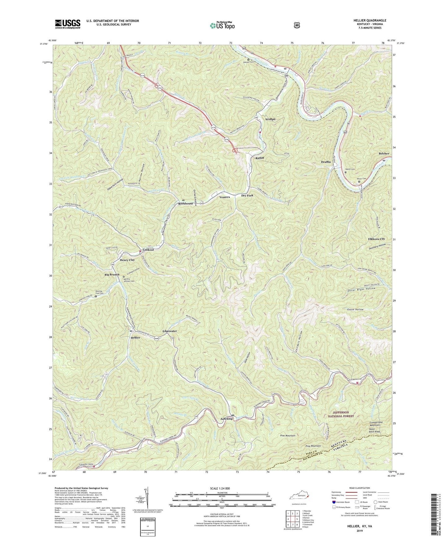
Hellier Kentucky US Topo Map
Couldn't load pickup availability
Also explore the Hellier Forest Service Topo of this same quad for updated USFS data
2022 topographic map quadrangle Hellier in the states of Kentucky, Virginia. Scale: 1:24000. Based on the newly updated USGS 7.5' US Topo map series, this map is in the following counties: Pike, Dickenson. The map contains contour data, water features, and other items you are used to seeing on USGS maps, but also has updated roads and other features. This is the next generation of topographic maps. Printed on high-quality waterproof paper with UV fade-resistant inks.
Quads adjacent to this one:
West: Dorton
Northwest: Pikeville
North: Millard
Northeast: Lick Creek
East: Elkhorn City
Southeast: Haysi
South: Clintwood
Southwest: Jenkins East
Contains the following named places: Adams Branch, Alka Post Office, Allegheny, Allegheny Mine, Ashcamp, Ashcamp Branch, Ashcamp Division, Ashcamp Post Office, Bad Fork, Beddow Siding, Belcher Post Office, Belcher School, Big Branch, Big Branch Post Office, Bowling Fork, Bowling Fork Cemetery, Brushy Branch, Camp Branch, Carmen Post Office, Cedar Post Office, Childers Hollow, Coal Fork Branch, Coaldale Junction, Community Baptist Church, Dave Hollow, Deadening Fork, Draffin, Drafin Post Office, Dry Fork, Earns Branch, Edgewater, Elkhorn City Fire Department Station 2, Elkhorn City Junction, Ferrell Creek, Garden Branch, Goose Hollow, Graveyard Hollow, Greenough Mine, Gum Branch, Harless Creek, Harless Creek School, Hellier, Hellier Division, Hellier Post Office, Hellier School, Henry Clay, Hurricane Branch, Jackson Branch, Jackson Branch School, Jessie Branch, Jimmie Creek, Joe Brown Fork, Johnson Branch, Johnson Cemetery, Johnson Fork, Kettlecamp, Kettlecamp Branch, Kettlecamp Church, Kettlecamp School, Laurel Branch, Laurel Fork, Left Fork Dry Creek, Left Fork Rockhouse Creek, Left Fork Sycamore Creek, Left Fork Wolfpit Branch, Liberty Hope Baptist Church, Lick Branch, Little Branch, Little Hattie Regular Baptist Church, Lookout, Lookout Elementary School, Lookout Post Office, Lookout Volunteer Fire and Rescue, Looney Railroad Siding, Lower Field Branch, Mancho Post Office, Mancho Railroad Station, Marion Branch, Maritha Johnson Cemetery, Marrowbone, Marrowbone - Regina Post Office, Marrowbone Creek, Marrowbone Railroad Station, Marrowbone School, Marrowbone Volunteer Fire Department, Marrowbone Volunteer Fire Department Station 2, Meadow Branch, Mill Branch, Mountain Branch, Nance Branch, Narrow Hollow, Old House Branch, Orchard Hollow, Oscar Right Hollow, Pine Grove Regular Baptist Church, Plymale Branch, Polerack Branch, Pond Creek, Pond Post Office, Poor Bottom Fork, Poor Bottom School, Ratliff, Ratliff Cemetery, Regina Post Office, Regina School, Right Fork Rockhouse Creek, Road Creek, Road Junction, Rockhouse, Rockhouse Creek, Rockhouse Post Office, Rockhouse Railroad Station, Rough Branch, Seng Branch, Shop Branch, Skeet Rock Knob, Snake Branch, Staggerweed Branch, Sycamore Creek, Sycamore React Volunteer Fire Department, Sycamore School, Toms Branch, Upper Greasy School, Upper Pond School, Upper Rockhouse School, Upper Wolfpit School, Uppertwin Hollow, Venters, Venters Railroad Station, Water Branch, Wilson Cemetery, Wolf Pit Post Office, Wolfpit, Wolfpit Branch, ZIP Codes: 41512, 41522, 41534, 41559