MyTopo
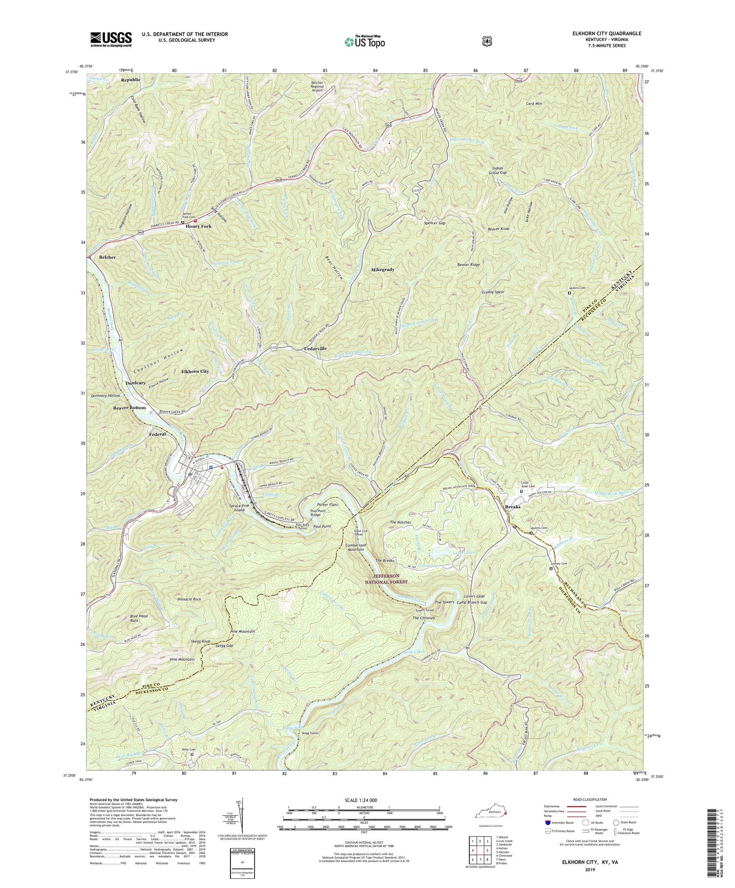
Elkhorn City Kentucky US Topo Map
Couldn't load pickup availability
Also explore the Elkhorn City Forest Service Topo of this same quad for updated USFS data
2022 topographic map quadrangle Elkhorn City in the states of Kentucky, Virginia. Scale: 1:24000. Based on the newly updated USGS 7.5' US Topo map series, this map is in the following counties: Pike, Dickenson, Buchanan. The map contains contour data, water features, and other items you are used to seeing on USGS maps, but also has updated roads and other features. This is the next generation of topographic maps. Printed on high-quality waterproof paper with UV fade-resistant inks.
Quads adjacent to this one:
West: Hellier
Northwest: Millard
North: Lick Creek
Northeast: Jamboree
East: Harman
Southeast: Prater
South: Haysi
Southwest: Clintwood
Contains the following named places: Abes Fork, Abner Fork, Axel Hollow, Bear Hollow, Beaver Bottom, Beaver Creek, Beaver Creek Church, Beaver Creek School, Beaver Knob, Beaver Ridge, Bee Tree Branch, Belcher, Belcher Post Office, Belcher Regional Airport, Big Branch, Big Island Branch, Blue Head Branch, Blue Head Rock, Blue Pond Fork, Board Fork, Breaks, Breaks Census Designated Place, Breaks Elementary School, Breaks Interstate Park, Breaks Post Office, Brushy Fork, Camp Branch Creek, Camp Branch Gap, Card Creek Church, Card Mountain, Cedar Grove Church, Cedarville, Chestnut Hollow, City of Cedarville, City of Elkhorn City, Clinchfield Overlook, Cold Bank Hollow, Cold Spring, Compton Fork, Cow Fork, Dilse Branch, Drafin School, Dunleary, Dunleary Hollow, Dunleary Post Office, Dunleary Railroad Station, Elkhorn City, Elkhorn City Division, Elkhorn City Fire Department, Elkhorn City Police Department, Elkhorn City Post Office, Elkhorn City Railroad Station, Elkhorn City School, Elkhorn Creek, Elswick Hollow, Falls Branch, Federal, Federal Railroad Station, Ferrell, Ferrell Creek Church, Ferrell Creek School, Ferrell Post Office, Ferrells Creek Area Fire Department, Flat Fork, Garden Hole, Grassy Church, Grassy Creek, Greasy Spear, Hogston Hollow, Honey Fork, Honey Fork Cemetery, Houselog Fork, Hunt Fork, Hunts Creek, Indian Grave Fork, Indian Grave Gap, Isham Fork, John Moore Branch, Laurel Branch, Laurel Lake, Laurel Lake Dam, Left Fork Beaver Creek, Little Grassy Branch, Little Island Branch, Little Josie Cemetery, Little Laurel Branch, Locust Thicket, Looney Cemetery, Lovers Leap, Lower Branch, Luke Hollow, Maple Camp Fork, Meadow Gap, Middle Branch, Middle Camp Branch, Middle Fork Hunts Creek, Middle Fork Road Creek, Middlefield Fork, Mike Grady Railroad Station, Mikegrady, Mouth of Beaver School, Mud Lick, Mullins Branch, Mullins Cemetery, Old House Fork, Piney Fork, Pinnacle Rock, Pond Branch, Pool Point, Pool Point Bridge, Pool Point Tunnel, Potter Branch, Potter Flats, Praise Fork, Priest Fork, Republic, Right Fork Beaver Creek, Road Fork, School House Branch, School Number Two, Senterville, Shop Branch, Shortridge Fork, Simms Branch, Skegg Branch, Skegg Gap, Skegg Hole, Skegg Knob, Skegg Tunnel, Slickrock Fork, Slone Fork, Song Hollow, Spencer Gap, Spring Branch, Spruce Pine Fork, Spruce Pine Island, State Line Overlook, State Line Tunnel, Steward Fork, Stonecoal Fork, Sulphur Springs Church, The Breaks, The Breaks Overlook, The Chimney, The Notches, The Towers, The Towers Overlook, Tilley Branch, Towers Tunnel, Trace Fork, Upper Branch, Upper Camp Branch, Upper Card Creek School, Upper Skegg Fork, Weddington Fork, Willis Branch, Willis Cemetery, Wolfpen Branch, ZIP Codes: 24607, 41513