MyTopo
Franklin Virginia US Topo Map
Couldn't load pickup availability
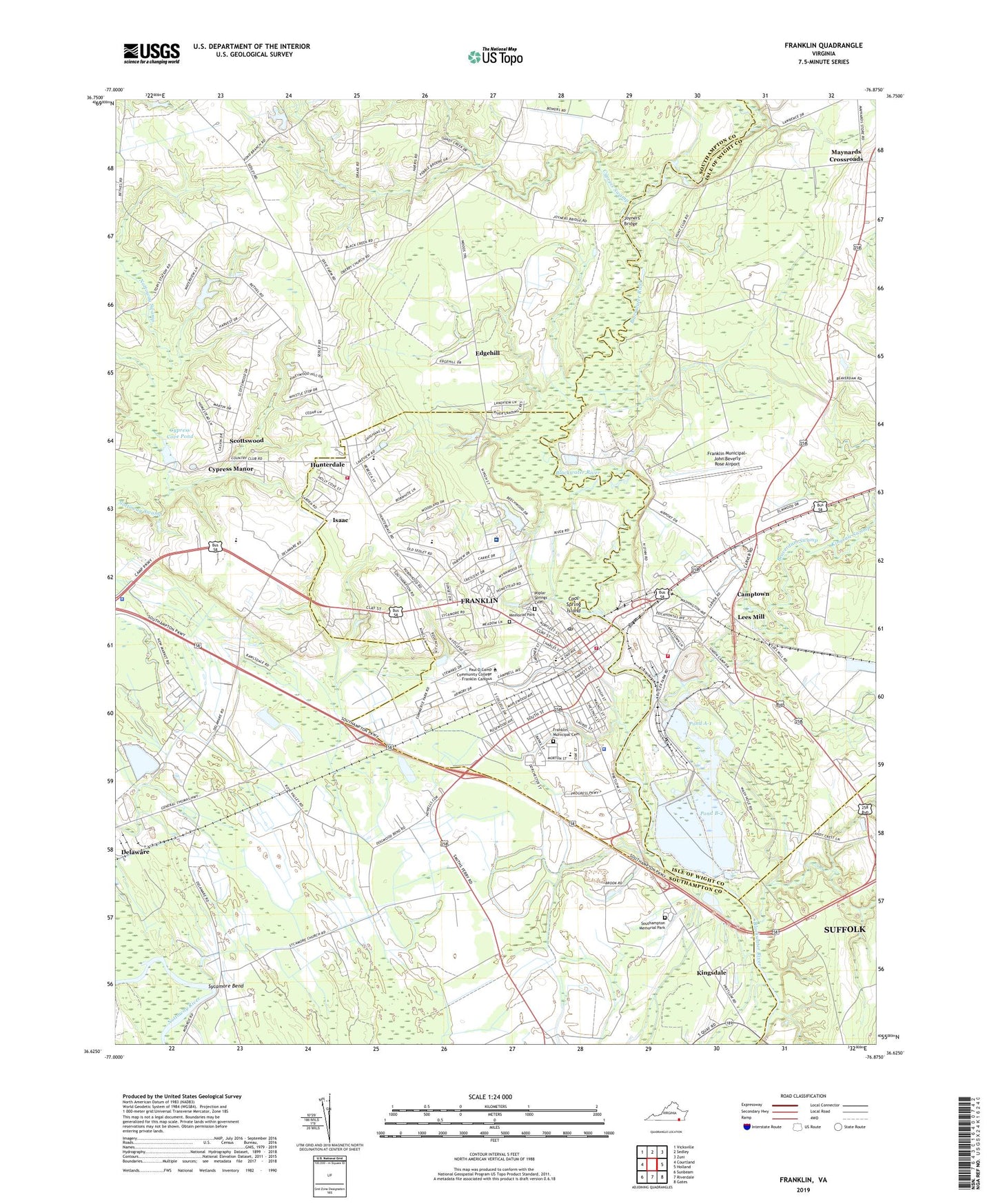
2019 topographic map quadrangle Franklin in the state of Virginia. Scale: 1:24000. Based on the newly updated USGS 7.5' US Topo map series, this map is in the following counties: Southampton, Isle of Wight, Franklin (city), Suffolk (city). The map contains contour data, water features, and other items you are used to seeing on USGS maps, but also has updated roads and other features. This is the next generation of topographic maps. Printed on high-quality waterproof paper with UV fade-resistant inks.
Quads adjacent to this one:
West: Courtland
Northwest: Vicksville
North: Sedley
Northeast: Zuni
East: Holland
Southeast: Gates
South: Riverdale
Southwest: Sunbeam
Contains the following named places: Airway Shopping Center, Allen Mission, Allen School, Beaverdam Swamp, Bethel Church, Bethel School, Blackwater Hunt Club, Bradshaw Store, Camp Dam, Camptown Census Designated Place, Camptown School, City of Franklin, Cool Spring Church, Cool Spring Island, Cypress Cove Country Club, Cypress Cove Dam, Cypress Cove Pond, Cypress Manor, Cypress Swamp, Edgehill, First Christian Church, Forks of the River Community Center, Franklin, Franklin Airport Industrial Park, Franklin Baptist Church, Franklin Church, Franklin City District Court, Franklin City Hall, Franklin District, Franklin Fire and Rescue Department, Franklin Fire and Rescue Pretlow Auxiliary Station 1A, Franklin Gymnasium, Franklin High School, Franklin Historic District, Franklin Municipal Pool, Franklin Plaza, Franklin Police Department, Franklin Post Office, Franklin Presbyterian Church, Franklin Public Library, Franklin Regional Airport, Hayden Grammar School, Hayden High School, High Street Methodist Episcopal Church, Holmes School, Hunterdale, Hunterdale Elementary School, Hunterdale Volunteer Fire Department, International Paper Company Fire Brigade, Isaac, James L Camp Jr YMCA, Joseph P King Jr Middle School, Joyners Bridge, Joyners Bridge Boat Ramp, Kingdom Hall of Jehovahs Witnesses, Kingsdale, Kingsdale Chapel, Lees Mill, Lees Millpond, Lone Pine School, Martin Luther King Jr Community Center, Maynards Crossroads, Memorial Park, Oak Grove School, Oberry Church, Oberry School, Paul D Camp Community College - Franklin Campus, Pleasant Shade Church, Pond A-1, Pond A-1 Dam, Pond B-2, Pond B-2 Dam, Poplar Springs Cemetery, Pretlow Industrial Park, Raiford Hospital, Ray Development Dam, Rock Church School, S P Morton Elementary School, Saint Johns Church, Saint Jules Church, Saint Lukes African Methodist Episcopal Church, Saint Mount Church, Sanctified Church, Scottswood, Southampton Memorial Hospital, Southampton Memorial Hospital Heliport, Southampton Memorial Park, Southeastern Public Service Authority Franklin Transfer Station, Southview Cemetery, Sycamore Bend, Sycamore Church, Union Chapel, Union Church, Virginia State Police Division 5 Area 34 Office, Watkins Corner, Webb School, White Oak Springs Church, WLQM-AM (Franklin), ZIP Code: 23851