MyTopo
Hoquiam Washington US Topo Map
Couldn't load pickup availability
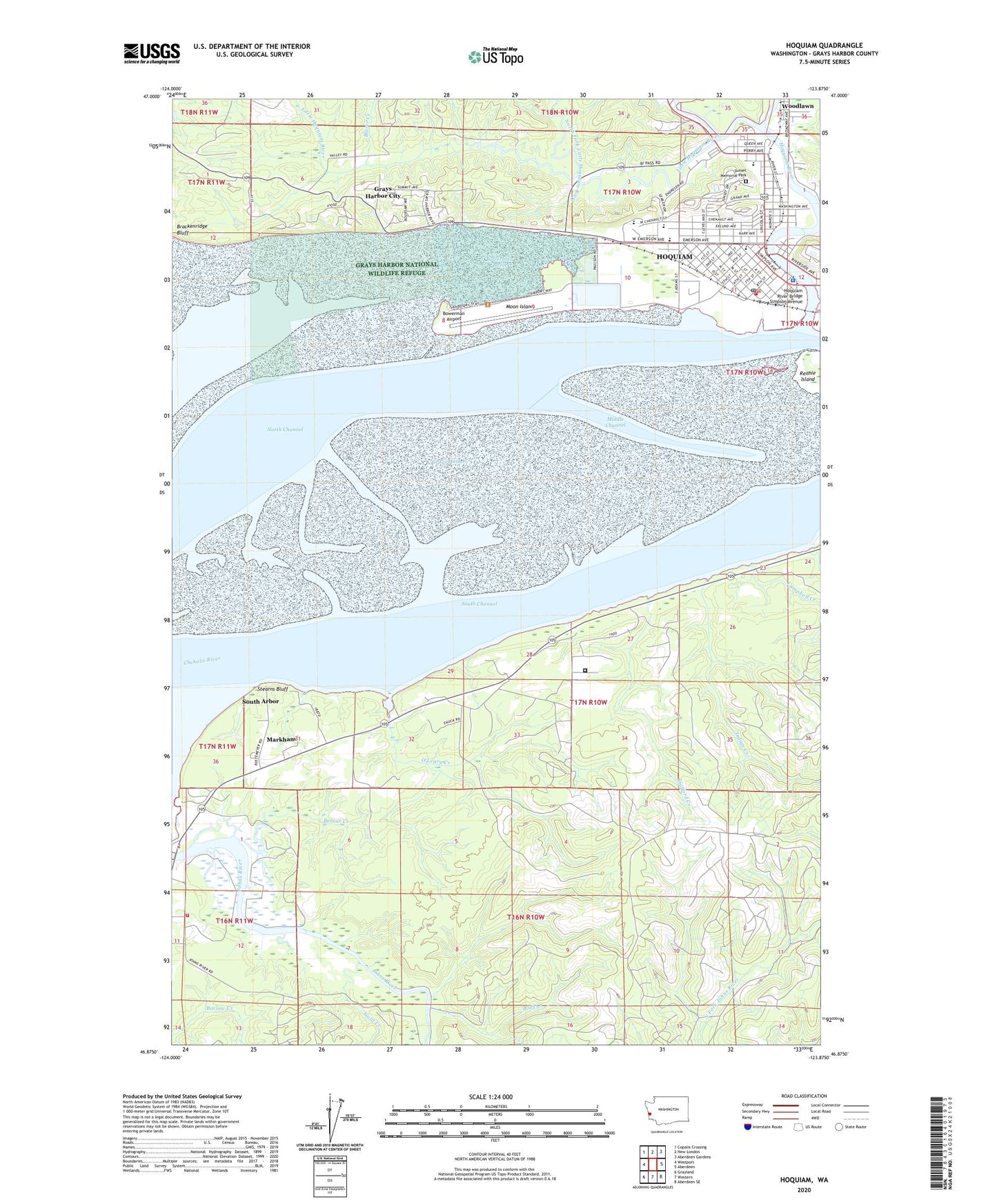
2023 topographic map quadrangle Hoquiam in the state of Washington. Scale: 1:24000. Based on the newly updated USGS 7.5' US Topo map series, this map is in the following counties: Grays Harbor. The map contains contour data, water features, and other items you are used to seeing on USGS maps, but also has updated roads and other features. This is the next generation of topographic maps. Printed on high-quality waterproof paper with UV fade-resistant inks.
Quads adjacent to this one:
West: Westport
Northwest: Copalis Crossing
North: New London
Northeast: Aberdeen Gardens
East: Aberdeen
Southeast: Aberdeen SE
South: Western
Southwest: Grayland
This map covers the same area as the classic USGS quad with code o46123h8.
Contains the following named places: Assisted Living Concepts Karr House, Beacon Hill Park, Beaver Creek, Blazer Creek, Bluff Creek, Bowerman Airport, Bowerman Basin, Campbell Creek, Central Elementary School, Channel Point Village, Chapin Creek, City of Hoquiam, East Fork Hoquiam River, Elton Bennett Park, Emerson Elementary School, First Baptist Church, First Presbyterian Church, Gold Creek, Grays Harbor Church of the Nazarene, Grays Harbor City, Grays Harbor Crisis Clinic, Grays Harbor Fire District 14 Ocosta Fire Department, Grays Harbor National Wildlife Refuge, Harbor Assembly of God Church, Hoquiam, Hoquiam City Hall, Hoquiam Fire Department, Hoquiam High School, Hoquiam Middle School, Hoquiam Police Department, Hoquiam Post Office, Hoquiam River, Hoquiam River Bridge Simpson Avenue, Hoquiam School District 28 Office, Hoquiam Timberland Library, Hoquiam Transit Station, Hoquiam Wastewater Treatment Plant, Immanuel Baptist Church, Indian Creek, John Gable Community Park, Johns River State Wildlife Recreation Area, Kingdom Hall of Jehovahs Witnesses, Last Spur Park, Lincoln Elementary School, Lincoln Park, Lincoln School, Lions City Park, Little Hoquiam River, Markham, Markham Census Designated Place, Middle Channel, Moon Island, North Channel, North Fork Little Hoquiam River, O'Leary Creek, Our Lady of Good Help Church, Polson Museum, Riverside Dike Park, Rosewood Manor Mobile Home Park, Rustemeyer Mobile Home Park, Saron Lutheran Church, Seventh Street Theatre, South Arbor, South Beach Ambulance Service, South Channel, Spar Point, Stafford Creek, Stafford Creek Corrections Center, Stearns Bluff, Sunset Memorial Park Cemetery, United Methodist Church of Hoquiam, Vida en Cristo Ministries, World of Praise United Church