MyTopo
Mount Rainier West Washington US Topo Map
Couldn't load pickup availability
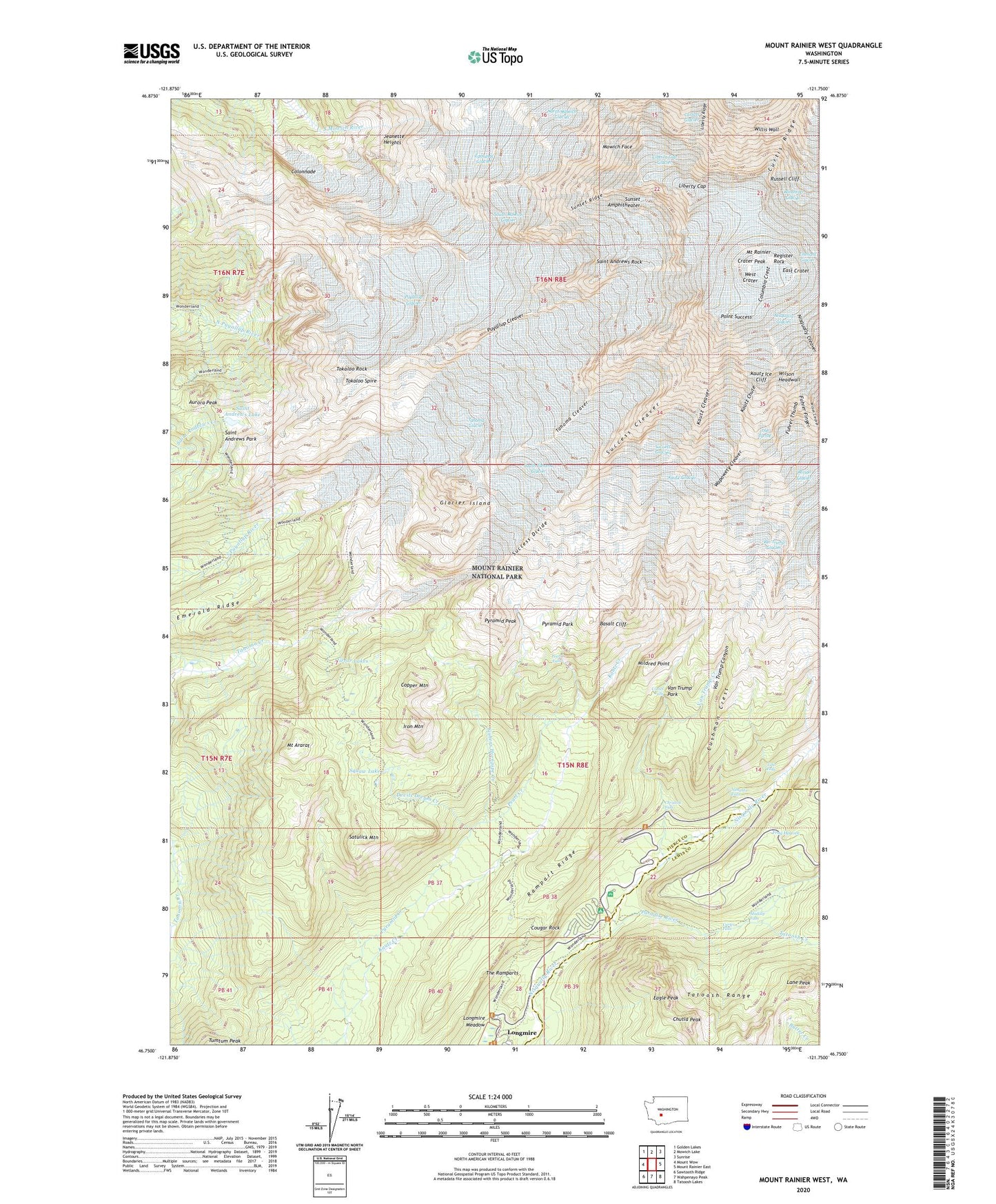
2023 topographic map quadrangle Mount Rainier West in the state of Washington. Scale: 1:24000. Based on the newly updated USGS 7.5' US Topo map series, this map is in the following counties: Pierce, Lewis. The map contains contour data, water features, and other items you are used to seeing on USGS maps, but also has updated roads and other features. This is the next generation of topographic maps. Printed on high-quality waterproof paper with UV fade-resistant inks.
Quads adjacent to this one:
West: Mount Wow
Northwest: Golden Lakes
North: Mowich Lake
Northeast: Sunrise
East: Mount Rainier East
Southeast: Tatoosh Lakes
South: Wahpenayo Peak
Southwest: Sawtooth Ridge
This map covers the same area as the classic USGS quad with code o46121g7.
Contains the following named places: Aurora Park, Aurora Peak, Avalanche Camp, Basalt Cliff, Camp Hazard, Canyon Rim View Point, Carter Falls, Cascade Range, Christine Falls, Chutla Peak, Colonnade, Columbia Crest, Comet Falls, Copper Mountain, Cougar Rock, Cougar Rock Campground, Crater Peak, Cushman Crest, Dead Horse Creek, Devils Dream Creek, Eagle Peak, East Crater, Edmunds Glacier, Emerald Ridge, Fish Creek, Fishers Hornpipe Creek, Frog Heaven, Fuhrer Finger, Fuhrer Thumb, Glacier Island, Indian Henrys Hunting Ground, Iron Mountain, Jeanette Heights, Kautz Chute, Kautz Cleaver, Kautz Glacier, Kautz Ice Cliff, Klapatche Park, Lane Peak, Liberty Cap, Liberty Gap Glacier, Liberty Ridge, Longmire Hotel, Longmire Meadow, Longmire Museum, Madcap Falls, Mildred Point, Mirror Lakes, Mount Ararat, Mount Rainier, Mowich Face, Nahunta Falls, Nisqually Cleaver, Nisqually Icefall, Paradise River, Pearl Creek, Pearl Falls, Point Success, Puyallup Cleaver, Puyallup Glacier, Pyramid Creek, Pyramid Glacier, Pyramid Glaciers, Pyramid Park, Pyramid Peak, Rampart Ridge, Register Rock, Ricksecker Point, Russell Cliff, Saint Andrews Lake, Saint Andrews Park, Saint Andrews Rock, Satulick Mountain, South Mowich Glacier, South Tahoma Glacier, Squaw Lake, Success Cleaver, Success Divide, Success Glacier, Sunset Amphitheater, Sunset Ridge, Tahoma Cleaver, Tahoma Glacier, Tato Falls, Tatoosh Creek, The Ramparts, The Turtle, Tokaloo Rock, Tokaloo Spire, Van Trump Canyon, Van Trump Creek, Van Trump Glacier, Van Trump Park, Wapowety Cleaver, West Crater, Willis Wall, Wilson Cleaver, Wilson Glacier, Wilson Headwall