MyTopo
Mowich Lake Washington US Topo Map
Couldn't load pickup availability
Also explore the Mowich Lake Forest Service Topo of this same quad for updated USFS data
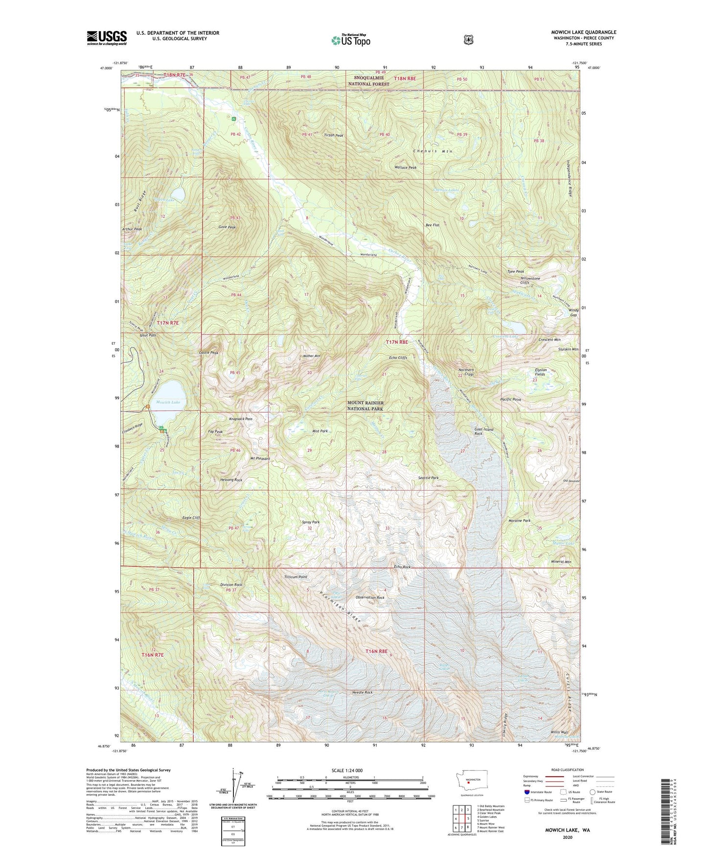
2023 topographic map quadrangle Mowich Lake in the state of Washington. Scale: 1:24000. Based on the newly updated USGS 7.5' US Topo map series, this map is in the following counties: Pierce. The map contains contour data, water features, and other items you are used to seeing on USGS maps, but also has updated roads and other features. This is the next generation of topographic maps. Printed on high-quality waterproof paper with UV fade-resistant inks.
Quads adjacent to this one:
West: Golden Lakes
Northwest: Old Baldy Mountain
North: Bearhead Mountain
Northeast: Clear West Peak
East: Sunrise
Southeast: Mount Rainier East
South: Mount Rainier West
Southwest: Mount Wow
This map covers the same area as the classic USGS quad with code o46121h7.
Contains the following named places: Alice Falls, Arthur Peak, Bee Flat, Carbon Glacier, Castle Peak, Cataract Creek, Cataract Falls, Cayada Creek, Chenuis Creek, Chenuis Falls, Chenuis Lakes, Chenuis Mountain, Crescent Creek, Crescent Lake, Crescent Mountain, Cress Falls, Curtis Ridge, Dick Creek, Division Rock, Doe Creek, Eagle Cliff, Echo Cliffs, Echo Rock, Elizabeth Ridge, Elysian Fields, Falls Creek, Fay Peak, Flett Glacier, Giant Falls, Goat Island Rock, Gove Peak, Grant Creek, Green Lake, Hessong Rock, Ipsut Creek, Ipsut Creek Campground, Ipsut Creek Trail, Ipsut Falls, Ipsut Pass, Knapsack Pass, Lake Tom, Lee Creek, Marmot Creek, Mineral Mountain, Mist Park, Moraine Creek, Moraine Park, Mother Mountain, Mount Pleasant, Mount Rainier Division, Mowich Lake, Mystic Lake, Needle Rock, North Mowich Glacier, Northern Crags, Northern Loop Trail, Observation Rock, Old Desolate, Pacific Point, Ptarmigan Ridge, Ranger Creek, Ranger Falls, Russell Glacier, Rust Ridge, Seattle Park, Spray Falls, Spray Park, Spukwush Creek, Tillicum Point, Tirzah Peak, Tyee Peak, Wallace Peak, Windy Gap, Yellowstone Cliffs