MyTopo
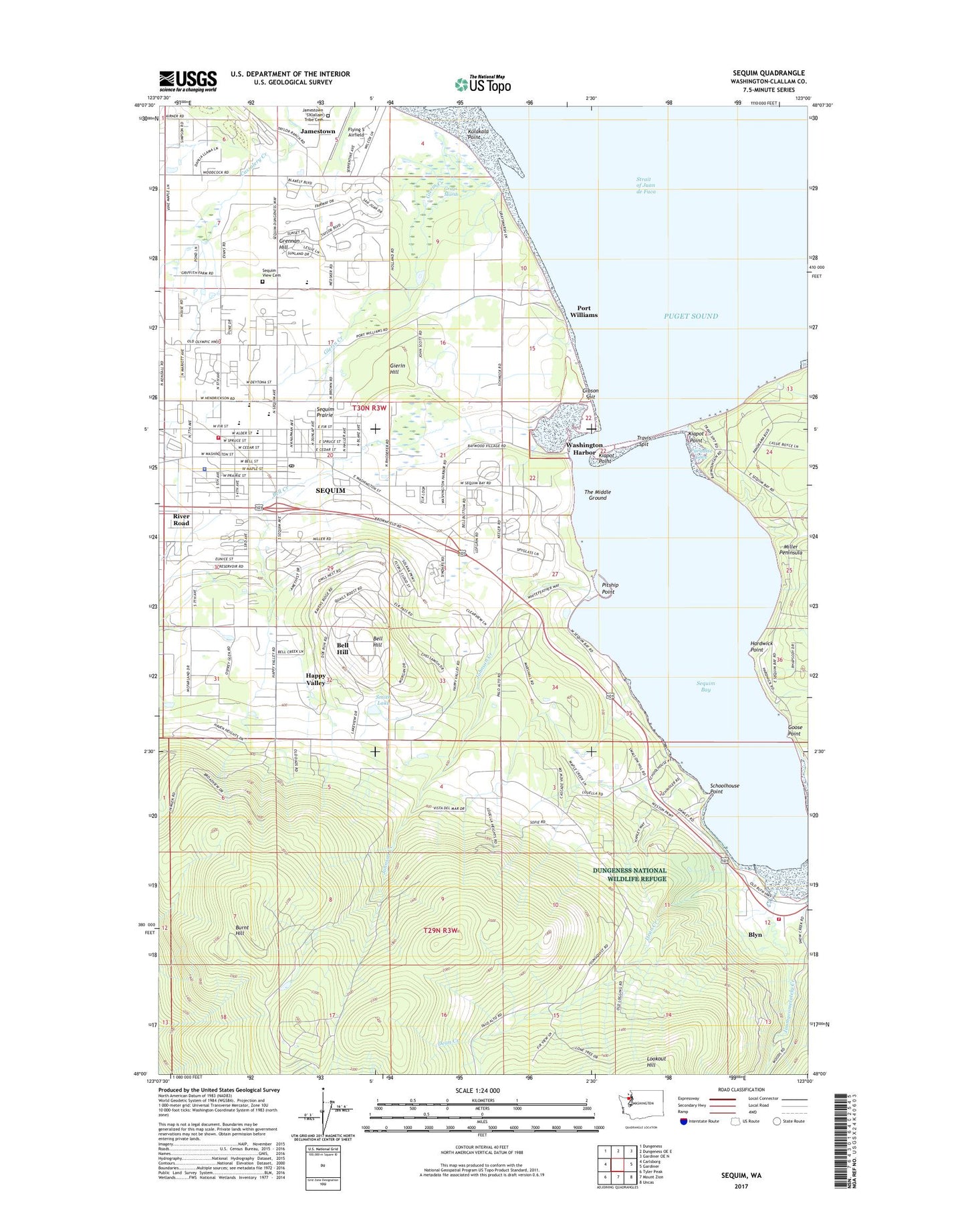
Sequim Washington US Topo Map
Couldn't load pickup availability
Also explore the Sequim Forest Service Topo of this same quad for updated USFS data
2023 topographic map quadrangle Sequim in the state of Washington. Scale: 1:24000. Based on the newly updated USGS 7.5' US Topo map series, this map is in the following counties: Clallam. The map contains contour data, water features, and other items you are used to seeing on USGS maps, but also has updated roads and other features. This is the next generation of topographic maps. Printed on high-quality waterproof paper with UV fade-resistant inks.
Quads adjacent to this one:
West: Carlsborg
Northwest: Dungeness
North: Dungeness OE E
Northeast: Gardiner OE N
East: Gardiner
Southeast: Uncas
South: Mount Zion
Southwest: Tyler Peak
This map covers the same area as the classic USGS quad with code o48123a1.
Contains the following named places: Baywood Village Mobile Home Park, Beck Ranch, Bell Creek, Bell Hill, Bell Hill Census Designated Place, Blyn, Burnt Hill, Camp Tapawingo, Church of God Olympic View, City Center Mobile Home Park, City of Sequim, Clallam County Fire District 3 Station 34, Clallam County Fire District 3 Station 37 Blyn, Clallam County Sheriff Department East Detachment, Clasen Cove Estates Mobile Home Park, Davis Field, Dean Creek, Discovery Memory Care Facility, Dukes Mobile Home Park, Duke's Private Airport, Dungeness Valley Lutheran Church, Faith Lutheran Church of Sequim, First Baptist Church of Sequim, Gaskell Slough, Gibson Spit, Gierin Creek, Gierin Hill, Goose Point, Grays Marsh, Grennan Hill, Happy Valley, Hardwick Point, Helen Haller Elementary School, Hendrickson Heritage Mobile Home Park, Hide Away Mobile Home Park, Jamestown Census Designated Place, Jamestown S'Klallam Reservation, Jamestown S'klallam Tribe Cemetery, Jimmycomelately Creek, John Wayne Marina, Johnson Creek, Juniper Mobile Estates, Kiapot Point, Kulakala Point, Littleneck Beach, Lookout Hill, Mountain View Christian School, O M H Airport, Olympic Ambulance, Olympic Care and Rehabilitation Center, Olympic Peninsula Academy, Pacific Northwest National Laboratory Sequim Marine Operations Laboratory, Paradise Cove, Pitship Point, Port Williams, Port Williams Picnic Area, Prairie Springs Assisted Living Facility, Saint Joseph's Roman Catholic Church, Saint Luke's Episcopal Church, Schoolhouse Point, Sequim, Sequim Bay, Sequim Bay State Park, Sequim Bay State Park Campground, Sequim Bay Yacht Club, Sequim Bible Christian Academy, Sequim Bible Church, Sequim Church of Religious Science, Sequim City Hall, Sequim Community Church, Sequim Community Head Start School, Sequim Division, Sequim Health and Rehabilitation Center, Sequim Library, Sequim Middle School, Sequim Museum and Arts Center, Sequim Police Department, Sequim Post Office, Sequim Prairie, Sequim Public Works Building, Sequim School District 323 Office, Sequim Senior High School, Sequim Transit Center, Sequim Valley Foursquare Church, Sequim View Cemetery, Sequim Wastewater Treatment Plant, Sequim West Mobile Home Park, Sequim Worship Center, Seventh Day Adventist Church of Sequim, Sherwood Assisted Living Facility, Smith Lake, Spruce West Mobile Home Park, Sunland Golf and Country Club, Sunland Water District Wastewater Treatment Plant, Sunnyside Mobile Court, The Church of Jesus Christ of Latter Day Saints, The Lagoon, The Middle Ground, Travis Spit, Trinity United Methodist Church, Washington Harbor, West Alder Mobile Home Park, ZIP Code: 98382