MyTopo
Branchland West Virginia US Topo Map
Couldn't load pickup availability
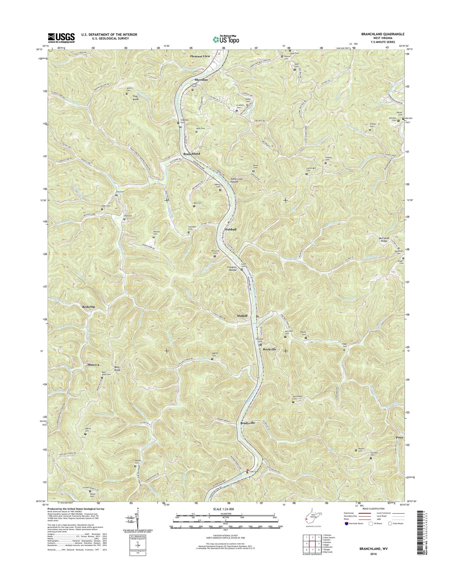
2019 topographic map quadrangle Branchland in the state of West Virginia. Scale: 1:24000. Based on the newly updated USGS 7.5' US Topo map series, this map is in the following counties: Lincoln, Cabell. The map contains contour data, water features, and other items you are used to seeing on USGS maps, but also has updated roads and other features. This is the next generation of topographic maps. Printed on high-quality waterproof paper with UV fade-resistant inks.
Quads adjacent to this one:
West: Nestlow
Northwest: Winslow
North: West Hamlin
Northeast: Hamlin
East: Hager
Southeast: Big Creek
South: Ranger
Southwest: Kiahsville
Contains the following named places: Adkins Cemetery, Bear Knob, Bear Knob Cemetery, Bee Branch, Big Creek School, Bluelick Branch, Bradyville, Branchland, Branchland Elementary School, Branchland Post Office, Buck Branch, Burger School, Burks Cemetery, Camp Branch, Camp Branch Church, Cartwright Cemetery, Chaney Cemetery, Chaney Fork, Chapman Cemetery, Church of God, Cooper Branch, Dial Cemetery, Dial School, Dick Fork, Edwards Cemetery, Falls Branch, Flag Knob, Flowers Cemetery, Fourmile Church, Fourmile Creek, Franklin Cemetery, Franklin Hollow, Fulks Cemetery, Furnett Creek, Guyan River Volunteer Fire Department, Guyan Valley High School, Guyan Valley Middle School, Hager Cemetery, Hager Fork, Hampton Cemetery, Harless Fork, Hollybush Branch, Horse Fork, Horseshoe Branch, Hubball, Hubball School, Hunters Point, Isaac Cemetery, Isaac School, Jeffers Cemetery, Keck Cemetery, Kentuck Fork, Kentuck Fork School, Kinder, Laurel Branch, Laurel Fork, Laurel Hill District, Lick Branch, Little Laurel Church, Little Laurel Creek, Lower Tenmile Church, Lower Twin Branch, Lowgap Branch, Lucas Cemetery, Lunsard Cemetery, McCallister Cemetery, McClarity Branch, McClarity Branch Church, McComas Branch, McComas Cemetery, McComas Ridge, Midkiff, Midkiff Elementary School, Midkiff Post Office, Mildred Church, Mill Branch, Minerva, Mount Zion Church, Ninemile Creek, Parsons Cemetery, Payne Cemetery, Peyton Branch, Peyton Cemetery, Pine Grove Church, Pine Grove School, Pleasant View, Pleasant View Elementary School, Porter Cemetery, Pound Fork, Price, Ranger Branch, Red River Fork, Redwing, Reuben Branch, Rockhouse Branch, Rockville, Roy Cemetery, Saunders Cemetery, Scites Cemetery, Sheridan, Sixmile Creek, Smith Cemetery, Spears Fork, Stone Coal Hollow, Stout Creek, Tenmile Church, Tenmile Creek, Thomas Branch, Trace Fork, Trace Fork School, Twomile Creek, Upper Twin Branch, Workman Cemetery, Works Cemetery, Yeager Cemetery, ZIP Codes: 25506, 25540