MyTopo
Grafton West Virginia US Topo Map
Couldn't load pickup availability
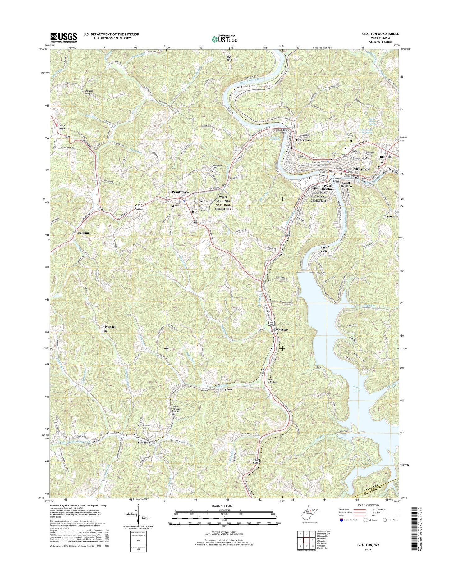
2023 topographic map quadrangle Grafton in the state of West Virginia. Scale: 1:24000. Based on the newly updated USGS 7.5' US Topo map series, this map is in the following counties: Taylor, Barbour. The map contains contour data, water features, and other items you are used to seeing on USGS maps, but also has updated roads and other features. This is the next generation of topographic maps. Printed on high-quality waterproof paper with UV fade-resistant inks.
Quads adjacent to this one:
West: Rosemont
Northwest: Fairmont West
North: Fairmont East
Northeast: Gladesville
East: Thornton
Southeast: Nestorville
South: Philippi
Southwest: Brownton
This map covers the same area as the classic USGS quad with code o39080c1.
Contains the following named places: Andrews Methodist Church, Anna Jarvis Birthplace Museum, Anna Jarvis Elementary School, Barnes School, Bartlett School, Belgium, Berkeley Run, Berkeley School, Berry Run, Bluemont Cemetery, Blueville, Blueville United Methodist Church, Boothsville Volunteer Fire Department Harmony Grove Substation, Bridge Street Bridge, Browns Knob, Brush Run, Brydon, Buck Run, Buck Run School, Carder Run, Carder School, Chicken Run, Church of the Covenant, City of Grafton, Doe Run, Dog Run, Dry Fork, East End School, Elliotsville, Evans Chapel United Methodist Church, Fall Hills, Fellowship Christian Academy, Fetterman, Fetterman United Methodist Church, First Baptist Church, First Christian Church, First Grace Brethren Church, Flag Run, Flag Run School, Flemington Elementary School, Gabe Fork, Gabe Fork School, Grafton, Grafton Cemetery, Grafton City Hall, Grafton City Hospital, Grafton Downtown Commerical Historic District, Grafton Fire Department, Grafton High School, Grafton Middle School, Grafton National Cemetery, Grafton Police Department, Grafton Post Office, Grafton Seventh Day Adventist Church, Grafton Wesleyan Holiness Church, Harmon Shopping Center, International Mother's Day Shrine, Jack Run, John F. Bennett Bridge, Joseph A Coy Spring, Lee Ward School, Long Run, Long Run Church, Long Run School, Lucas Dairy Spring, Lucretia, Lynn Chapel, Lynn School, Mount Calvary Cemetery, New Testament Christ Academy, North Simpson Girder, Otter Creek, Park View, Park View Church of the Nazarene, Park View School, Parkersburg Junction, Pleasant Creek, Post School, Pruntytown, Pruntytown Correctional Center, Pruntytown Correctional Facility, Pruntytown Elementary School, Pruntytown State Farm Wildlife Management Area, Rose Hill Church, Rose Hill Methodist Church, Saint Augustine Catholic Church, Saint Augustine School, Saint Johns United Methodist Church, Saint Marys Street Bridge, Saint Matthias Episcopal Church, Saint Pauls Methodist Church, Sand Lick Run, Sand Lick School, Scab Run, Shaw Run, Shelby Run, Short Run, Simpson, Simpson High School, Simpson Post Office, Smith Cemetery, South Grafton, Southside Bridge, Stone House, Sugar Grove School, Taylor County, Taylor County Courthouse, Taylor County Emergency Company 40, Taylor County Jail, Taylor County Middle School, Taylor County Public Library, Taylor County Sheriff's Office, Taylor County Technical Center, Three Fork Creek, Towles Camp, Trinity United Methodist Church, Tucker Run, Tygart Dam, Tygart District, Tygart Lake, Tygart Lake State Park, Union Baptist Church, Union Baptist Church Cemetery, Victor Lucas Dairy Spring, Walnut Grove Cemetery, Warren United Methodist Church, Webster, Webster Baptist Church, Wendel, Wendel Post Office, West Grafton, West Hill Church, West Hill School, West Main Street Methodist Church, West Side School, West Virginia Industrial School for Boys, West Virginia National Cemetery, West Virginia State Police Troop 1 - Grafton Detachment, Wickwire Run, Woodsdale Cemetery, WTBZ-AM (Grafton), WTBZ-FM (Grafton), Yates, ZIP Codes: 26354, 26435