MyTopo
Montrose West Virginia US Topo Map
Couldn't load pickup availability
Also explore the Montrose Forest Service Topo of this same quad for updated USFS data
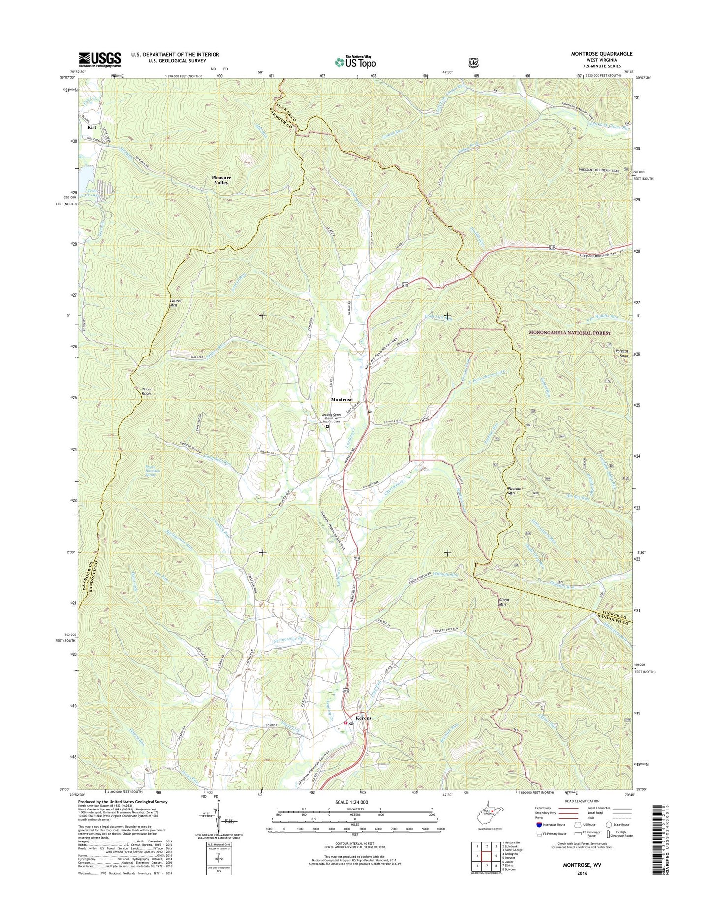
2023 topographic map quadrangle Montrose in the state of West Virginia. Scale: 1:24000. Based on the newly updated USGS 7.5' US Topo map series, this map is in the following counties: Randolph, Tucker, Barbour. The map contains contour data, water features, and other items you are used to seeing on USGS maps, but also has updated roads and other features. This is the next generation of topographic maps. Printed on high-quality waterproof paper with UV fade-resistant inks.
Quads adjacent to this one:
West: Belington
Northwest: Nestorville
North: Colebank
Northeast: Saint George
East: Parsons
Southeast: Bowden
South: Elkins
Southwest: Junior
This map covers the same area as the classic USGS quad with code o39079a7.
Contains the following named places: Baldlick Fork, Brights Run, Bryan Hamilton Spring, Campfield Run, Central School, Cherry Fork, Cherry Fork School, Choke Trap Run, Davis Lick, East Fork Cherry Fork, Elkins Speedway, Gainer School, Grasslick Run, Harper Schoolhouse, Hart Chapel, Hunting Camp Run, Indian Run, Israel Church, Israel School, Ivy Hill School, Kerens, Kerens Post Office, Kirt, Laurel Hill School, Laurel Run, Lazy Run, Leading Creek Primitive Baptist Cemetery, Leading Creek Volunteer Fire Department, Little Laurel Run, Mill Run, Montrose, Montrose Post Office, New Interest District, Oak Grove School, Panther Run, Pheasant Mountain Trail, Pleasant Mountain, Pleasure Valley, Polecat Knob, Pond Lick Run, Salem School, Saltlick Run, Slabcamp Run, Smith Crossing, South Branch, South Haddix Trail, Springstone Run, Tar Run, Teter Creek Lake, Teter Creek Lake Wildlife Management Area, Thorn Knob, Town of Montrose, Union Chapel, Valley Fork, Victory School, Wilmoth Run, ZIP Codes: 26276, 26283