MyTopo
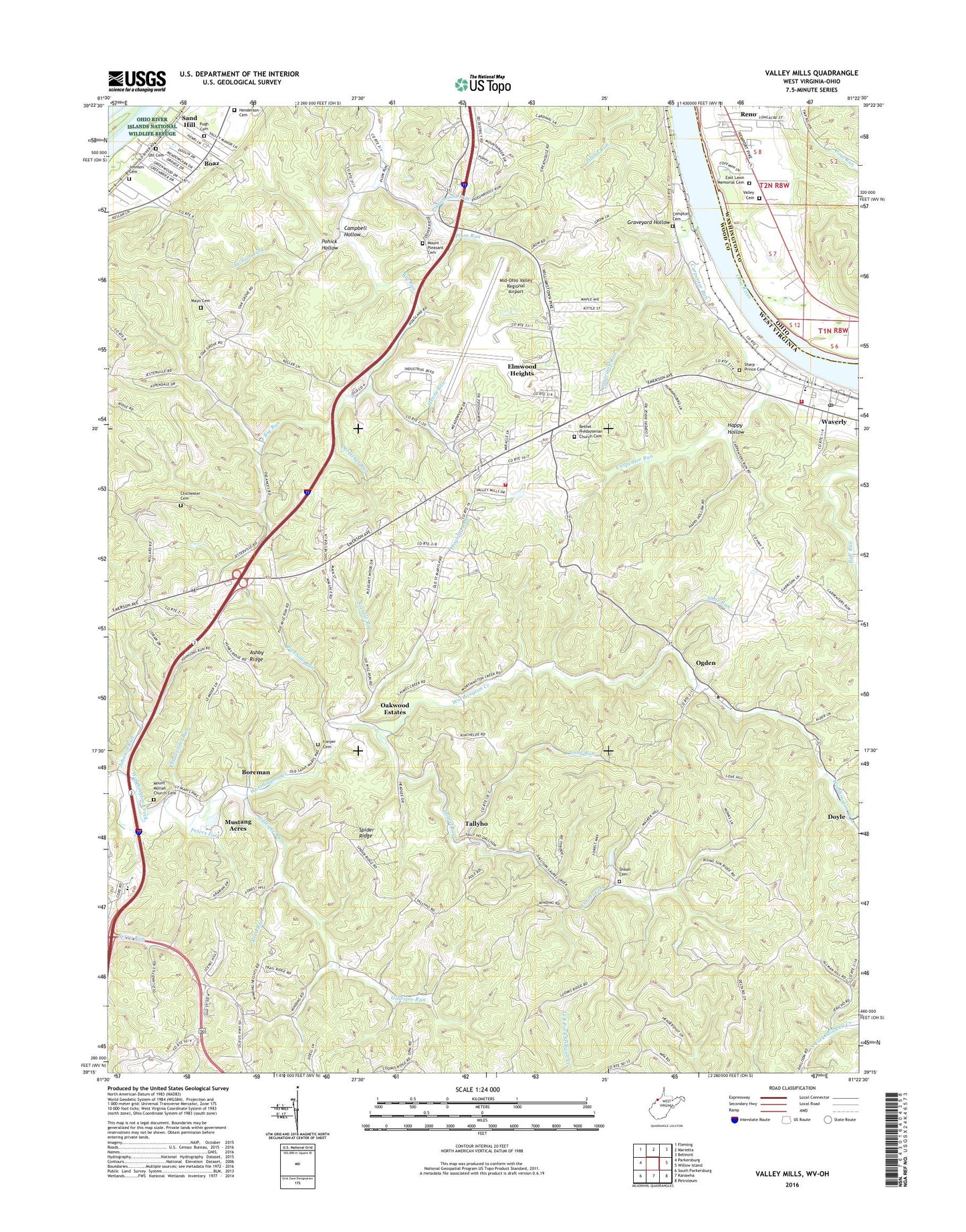
Valley Mills West Virginia US Topo Map
Couldn't load pickup availability
Also explore the Valley Mills Forest Service Topo of this same quad for updated USFS data
2023 topographic map quadrangle Valley Mills in the states of West Virginia, Ohio. Scale: 1:24000. Based on the newly updated USGS 7.5' US Topo map series, this map is in the following counties: Wood, Washington. The map contains contour data, water features, and other items you are used to seeing on USGS maps, but also has updated roads and other features. This is the next generation of topographic maps. Printed on high-quality waterproof paper with UV fade-resistant inks.
Quads adjacent to this one:
West: Parkersburg
Northwest: Fleming
North: Marietta
Northeast: Belmont
East: Willow Island
Southeast: Petroleum
South: Kanawha
Southwest: South Parkersburg
This map covers the same area as the classic USGS quad with code o39081c4.
Contains the following named places: Air Evac Lifeteam 82, Ashby Ridge, Ashby Ridge Estates, Ashby School, Bethel Presbyterian Church, Bethel Presbyterian Church Cemetery, Boaz Census Designated Place, Boreman, Boreman School, Brierwood, Campbell Hollow, Carpenter Road, Carpenter Run, Chancellors Run, Chichester Cemetery, Clay School, Compton Cemetery, Core Road School, Darling School, Delaney, Doyle, East Lawn Memorial Cemetery, Eastwood Addition, Elmwood Heights, Fivemile Run, Gillespie Run, Golf Club of West Virginia, Graveyard Hollow, Green Meadows Addition, Greenbrier Addition, Happy Hollow, Harper Cemetery, Henderson Cemetery, Henry Run, Hillcrest, Hogland Run, Jackson Fork, James Lane, Johnson Cemetery, Johnson Run, Jungle Drive-in, Laurel Fork, Liberty Hills, Lock Number 17, Long Run, Lower Darling School, Lumoos School, Marietta State Forest Nursery, Marietyta Unit Office - Athens Ranger District, Mayo Cemetery, Mid-Ohio Valley Regional Airport, Mount Moriah Church, Mount Moriah Church Cemetery, Mount Pleasant Cemetery, Mount Pleasant Church, Mustang Acres, Northwood Villa Estates, Oak Grove School, Oakwood Estates, Ogden, Ohio State Highway Patrol - Marietta Patrol Post, Old Boreman School, Old Posey Landing, Parkers Towne, Parkersburg Christian School, Parkersburg Wood County Airport Security, Parmeta Crest, Peters Fork, Pigeonroost Run, Pigeonroost Run School, Pine Grove Church, Pleasant Valley School, Plum Run, Pohick Hollow, Ponderosa, Pugh Cemetery, Reed Run, Reno, Reno Landing, Reno Post Office, Rising Sun School, Rolling Hills, Sand Hill, Scenic Hills, Sharp - Prince Cemetery, Shiloh Cemetery, Shiloh United Methodist Church, Sixmile Run, Slate Run, Southgate Mobile Home Park, Spider Ridge, Stretchet Run, Sugarcamp Run, Tallyho, Tennants Farm Pond Dam, Uhl Cemetery, Union District, Union Valley Church, Valley Cemetery, Valley Church, Valley Manor Addition, Valley Mills, Veterans Memorial Park, Waverly, Waverly Census Designated Place, Waverly Elementary School, Waverly Post Office, Waverly Public Library, Waverly Volunteer Fire Company, Waverly Volunteer Fire Department Station 2, Williams District, Winding Road Addition, Winding School, WMBP-FM (Belpre), ZIP Codes: 26104, 26187