MyTopo
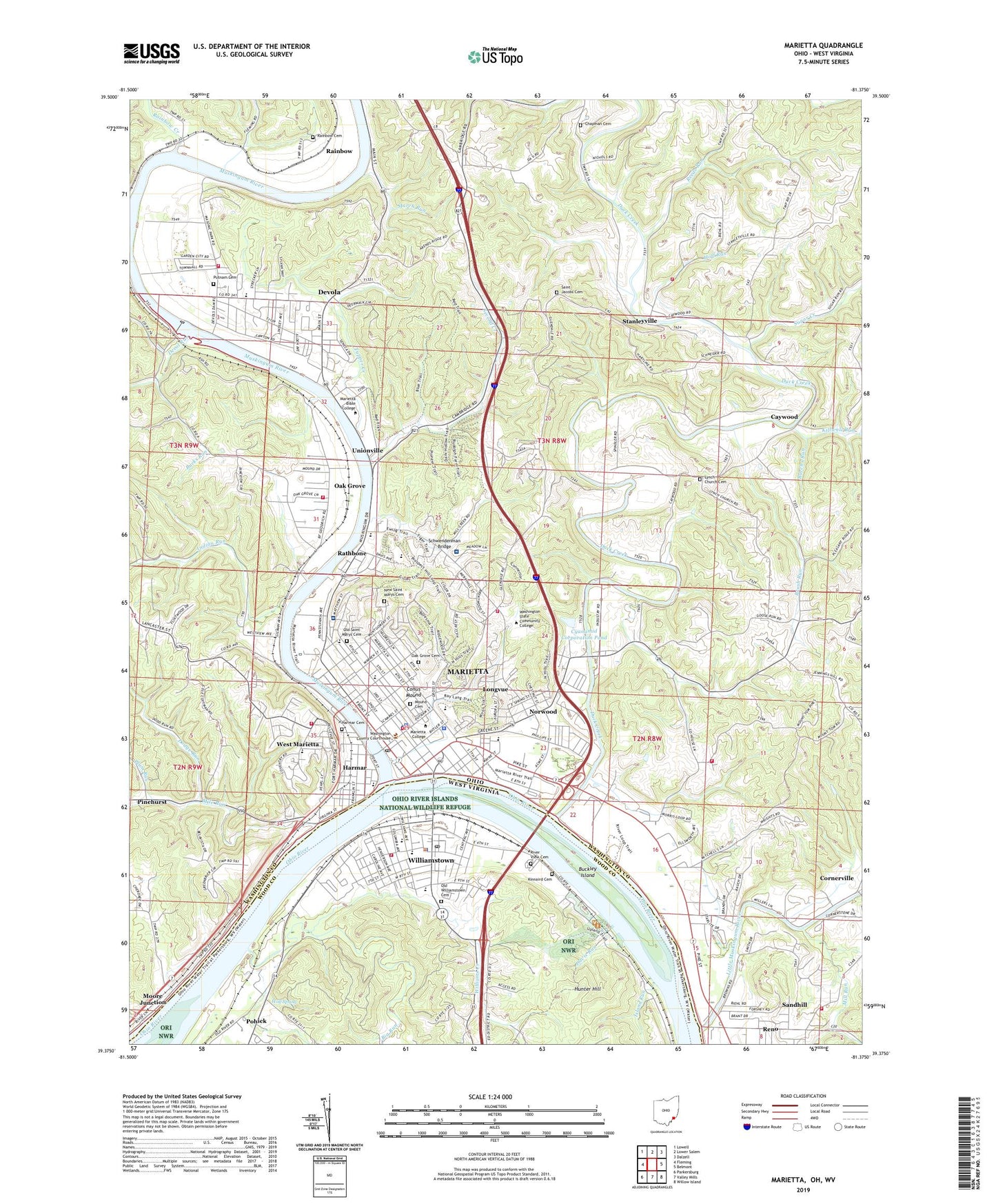
Marietta Ohio US Topo Map
Couldn't load pickup availability
Also explore the Marietta Forest Service Topo of this same quad for updated USFS data
2023 topographic map quadrangle Marietta in the states of Ohio, West Virginia. Scale: 1:24000. Based on the newly updated USGS 7.5' US Topo map series, this map is in the following counties: Washington, Wood. The map contains contour data, water features, and other items you are used to seeing on USGS maps, but also has updated roads and other features. This is the next generation of topographic maps. Printed on high-quality waterproof paper with UV fade-resistant inks.
Quads adjacent to this one:
West: Fleming
Northwest: Lowell
North: Lower Salem
Northeast: Dalzell
East: Belmont
Southeast: Willow Island
South: Valley Mills
Southwest: Parkersburg
Contains the following named places: Alumni Hall, Andrews Hall, Argan Landing, Arlington Heights, Ban Johnson Field House, Biehl's Dairy Farm, Big Run, Brush Run, Buckeye Park, Buckley Island, Bucks Run, Burchs Run, Butchs Cola Museum, Campus Martius Museum, Caywood, Caywood Christmas Tree Farms, Cedar Ridge Church, Central Christian Church, Chapman Cemetery, Childrens Toy and Doll Museum, Christ Memorial Church, Christ United Methodist Church, Church of Christ, Church of God, City of Marietta, City of Williamstown, Coal Run, Conus Mound, Crown of Life Evangelical Lutheran Church, Cyanamid Corporation Pond, Cyanamid Corporation Pond Dam, Dam Number 1, Dam Number 2, Davis Run, Dawes Memorial Library, Devol Run, Devola, Devola Census Designated Place, Devola Volunteer Fire Company, Dodge Run, Don Drumm Stadium, Dorothy Webster Hall, Douglas Putnam Hall, Duck Creek, East Muskingum Park, East Norwood, East Norwood Trailer Park, Edward Rolfe Brown Hall, Eisners Landing, Elsie Newton Hall, Emerson, Emerson Heights, Erwin Hall, Ewing School, Fairview Heights, Fairview Heights Elementary School, Faith Bible Church, Faith United Methodist Church, Fayer Weather Hall, Fearing Township Fire Department, First Baptist Church, First Baptist Church of Williamstown, First Church of the Nazarene, First Congregational Church, First Presbyterian Church, Fort Harmar Assembly of God Church, Fort Harmar Monument, Fort Harmer, Friendly Acres, Frontier Shopping Center, Gilman Student Center, Gilman United Methodist Church, Goose Creek, Grace Gospel Church, Grand View, Greenleaf Compost Farm, Harmar, Harmar Cemetery, Harmar Congregational Church, Harmar Elementary School, Harmar Hill Chapel, Harmar Hill Church of Christ, Harmar Historic District, Hoff Run, Hunter Hill, Indian Acres Park, Indian Run, Island Run, Killwell Run, Kinnaird Cemetery, Lafayette Shopping Center, Little Kingdom Valley Farms, Little Muskingum River, Lock Number 2, Longvue, Lookout Park, Lynch Church, Lynch Church Cemetery, March Run, Marietta, Marietta Bible Center, Marietta Church of Christ, Marietta City Hall, Marietta College, Marietta Fire Department Station 1, Marietta Fire Department Station 3, Marietta Fire Department Station 4, Marietta High School, Marietta Historic District, Marietta Industrial Park, Marietta Marina Trailer Park, Marietta Memorial Hospital, Marietta Middle School, Marietta Police Department, Marietta Post Office, Marietta Seventh Day Adventist Church, Marietta Water Treatment Plant, Marion Elementary School, Mary O Beach Hall, Mile Run, Mill Run, Mills Hall, Moore Junction, Morningside, Mound Cemetery, Mount Everett, Muskingum Park, Muskingum River, Muskingum River Lock and Dam Number, Muskingum River Lock and Dam Number Two, Muskingum Terrace, New Life United Pentecostal Church, New Saint Marys Cemetery, North Hills, North Hills Elementary School, Norwood, Norwood Mobile Home Park, Norwood School, Norwood United Methodist Church, Oak Grove, Oak Grove Cemetery, Oak Grove Elementary School, Oak Grove Fire Department, Oakwood Park, Ohio Riverfront Park, Old Saint Marys Cemetery, Old Williamstown Cemetery, Open Door Baptist Church, Parsons Hall, Phillips Elementary School, Pinehurst, Pioneer Park, Plum Run, Pohick, Putnam Cemetery, Putnam Church, Putnam Elementary School, Putnam Place, Quadranaou Park, Rainbow, Rainbow Cemetery, Rainbow Creek, Rathbone, Rathbone Heights, Reeds Run, Reno Census Designated Place, Reno Christian Church, Reno Elementary School, Reno Volunteer Fire Department Station 1, Reno Volunteer Fire Department Station 2, Repparts Landing, River View Cemetery, Riverdale, Ruraldale, Sacra Via Park, Saint Jacobs Cemetery, Saint Jacobs Church, Saint Lukes Episcopal Church, Saint Lukes Lutheran Church, Saint Marys Catholic Church, Saint Mary's School, Saint Pauls United Church of Christ, Sand Hill United Methodist Church, Sandhill, Schwendenman Bridge, Second Creek, Selby General Hospital, Selby General Hospital Heliport, Selby Hospital, Springdale, Stanleyville, Stanleyville Elementary School, Sugar Creek, Township of Fearing, Township of Marietta, Township of Muskingum, Trinity Methodist Episcopal Church, Tupper Creek, Unionville, Unitarian Universalist Church, Wagner Union Church, Washington County, Washington County Childrens Home, Washington County Courthouse, Washington County Fairgrounds, Washington County Home, Washington County Public Library, Washington County Sheriff's Office, Washington Elementary School, Washington Shopping Center, Wayne Street Congregational Church, WBRJ-AM (Marietta), WCMO-FM (Marietta), West Marietta, Western Hills, Westview, William Bay Irvine Administration Building, Williams Creek, Williamstown, Williamstown Church of Christ, Williamstown Elementary School, Williamstown High School, Williamstown Junior-Senior High School, Williamstown Police Department, Williamstown Post Office, Williamstown Public Library, Williamstown Volunteer Fire Department, Willow Farm, Willow Springs Chapel, WMOA-AM (Marietta), WMRT-FM (Marietta), Wolf Spring, Wood County Christian School, Zimmerview Dairy Farm, ZIP Code: 45750