MyTopo
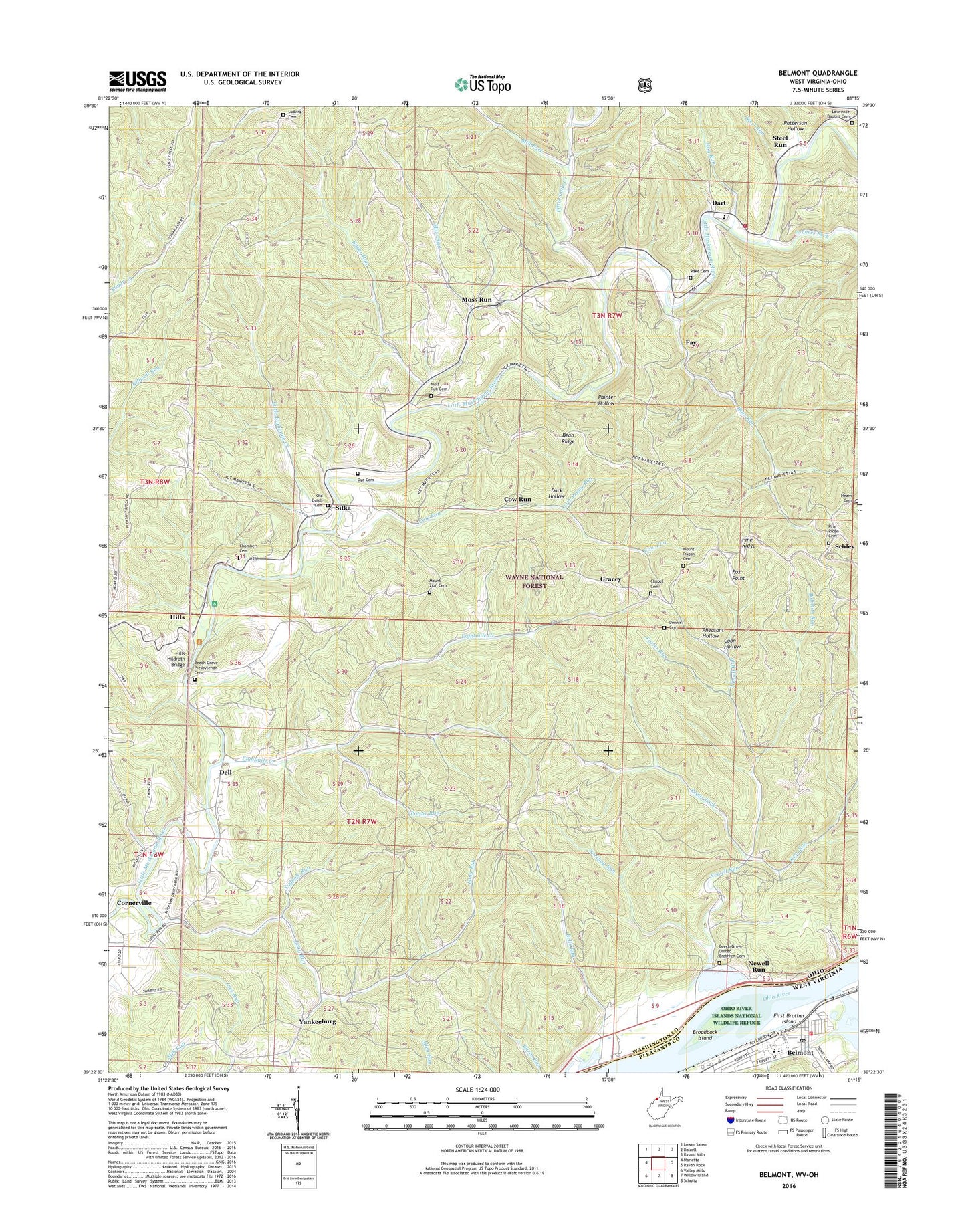
Belmont West Virginia US Topo Map
Couldn't load pickup availability
Also explore the Belmont Forest Service Topo of this same quad for updated USFS data
2023 topographic map quadrangle Belmont in the states of Ohio, West Virginia. Scale: 1:24000. Based on the newly updated USGS 7.5' US Topo map series, this map is in the following counties: Pleasants, Washington. The map contains contour data, water features, and other items you are used to seeing on USGS maps, but also has updated roads and other features. This is the next generation of topographic maps. Printed on high-quality waterproof paper with UV fade-resistant inks.
Quads adjacent to this one:
West: Marietta
Northwest: Lower Salem
North: Dalzell
Northeast: Rinard Mills
East: Raven Rock
Southeast: Schultz
South: Willow Island
Southwest: Valley Mills
This map covers the same area as the classic USGS quad with code o39081d3.
Contains the following named places: Archers Fork, Baker Run, Bean Ridge, Bear Run, Bear Run Church, Beech Grove Presbyterian Cemetery, Beech Grove Presbyterian Church, Beech Grove United Brethren Cemetery, Beech Grove United Brethren Church, Bells Run, Belmont, Belmont Baptist Church, Belmont Elementary School, Belmont Post Office, Belmont United Methodist Church, Belmont Volunteer Fire Department, Bolivian Run, Bowersock Dairy Farm, Broadback Island, Chambers Cemetery, Chapel Cemetery, City of Belmont, Clarks Landing, Coon Hollow, Cornerville, Cow Run, Dark Hollow, Dart, Dell, Dennis Cemetery, Dye Cemetery, Eightmile Creek, Fay, Fifteenmile Creek, First Brother Island, Fox Point, French Creek, Goss Fork, Gracey, Grange Hall, Grimm's Green Acres Farm, Hearn Cemetery, Hills, Hills Hildreth Bridge, Hog Run, Kerr Run, Lawrence Baptist Cemetery, Lawrence Baptist Church, Lawrence Elementary School, Lawrence High School, Leonards Landing, Lick Prong Run, Lick Run, Little Eightmile Creek, Little Muskingum Volunteer Fire Department, Long Run, Ludwig Cemetery, McElroys Run, Mill Fork, Moss Run, Moss Run Cemetery, Moss Run Church, Mount Pisgah Cemetery, Mount Zion Cemetery, Newell Run, Northup Run, Number Nine Church, Old Dutch Cemetery, Painter Hollow, Patterson Hollow, Peggs Fork, Pheasant Hollow, Pine Ridge, Pine Ridge Cemetery, Pine Ridge Church, Pleasants County Middle School, Porter Run, Potpie Run, Rake Cemetery, Schley, Schnaufers Landing, Sitka, Steel Run, Tadpole Run, Township of Lawrence, Township of Newport, Yankeeburg, ZIP Codes: 45768, 45773