MyTopo
Kaycee Wyoming US Topo Map
Couldn't load pickup availability
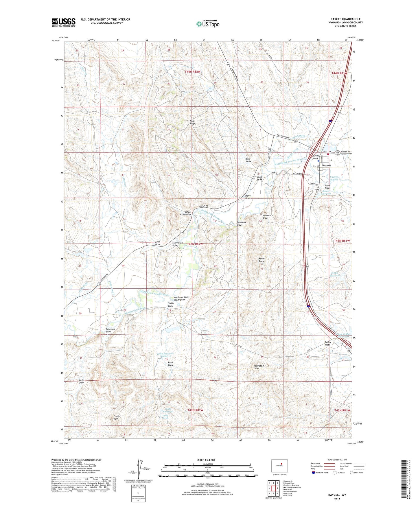
2021 topographic map quadrangle Kaycee in the state of Wyoming. Scale: 1:24000. Based on the newly updated USGS 7.5' US Topo map series, this map is in the following counties: Johnson. The map contains contour data, water features, and other items you are used to seeing on USGS maps, but also has updated roads and other features. This is the next generation of topographic maps. Printed on high-quality waterproof paper with UV fade-resistant inks.
Quads adjacent to this one:
West: Red Fork Powder River
Northwest: Mayoworth
North: Hibbard Draw
Northeast: Dry Creek Reservoir
East: Kaycee NE
Southeast: Wall Creek
South: TTT Ranch
Southwest: Hole-in-the-Wall
This map covers the same area as the classic USGS quad with code o43106f6.
Contains the following named places: Alkali Creek, Arndt Draw, Bailey Flats, Bentonite Draw, Bentonite Draw Mine, Castle Rock, Cottonwood Creek, Fauber Number 1 Dam, Fauber Number 1 Reservoir, Fauber Ranch, Fisher Dam, Fisher Draw, Fisher Ranch, Fisher Reservoir, Gosney Airport, Gosney Ranch, H. N. Thompson Mine, Haines Ranch, Hawk Draw, Kaycee, Kaycee Bentonite Corporation Mine Number Fifty-six, Kaycee Bentonite Corporation Number Eighty Mine, Kaycee Bentonite Corporation Number Eighty-eight Mine, Kaycee Bentonite Corporation Number Eighty-five Mine, Kaycee Bentonite Corporation Number Eighty-nine Mine, Kaycee Bentonite Corporation Number Eighty-seven Mine, Kaycee Bentonite Corporation Number Eighty-six Mine, Kaycee Bentonite Corporation Number Eighty-two Mine, Kaycee Bentonite Corporation Number Fifty Mine, Kaycee Bentonite Corporation Number Fifty-eight Mine, Kaycee Bentonite Corporation Number Fifty-four Mine, Kaycee Bentonite Corporation Number Fifty-one Mine, Kaycee Bentonite Corporation Number Fifty-three Mine, Kaycee Bentonite Corporation Number Forty-nine Mine, Kaycee Bentonite Corporation Number Ninety Mine, Kaycee Bentonite Corporation Number Ninety-five Mine, Kaycee Bentonite Corporation Number Ninety-one Mine, Kaycee Bentonite Corporation Number Ninety-three Mine, Kaycee Bentonite Corporation Number Ninety-two Mine, Kaycee Bentonite Corporation Number One Mine, Kaycee Bentonite Corporation Number Seventy Mine, Kaycee Bentonite Corporation Number Seventy-five Mine, Kaycee Bentonite Corporation Number Seventy-four Mine, Kaycee Bentonite Corporation Number Seventy-nine Mine, Kaycee Bentonite Corporation Number Seventy-one Mine, Kaycee Bentonite Corporation Number Seventy-seven Mine, Kaycee Bentonite Corporation Number Seventy-two Mine, Kaycee Bentonite Corporation Number Sixty Mine, Kaycee Bentonite Corporation Number Sixty-five Mine, Kaycee Bentonite Corporation Number Sixty-four Mine, Kaycee Bentonite Corporation Number Sixty-one Mine, Kaycee Bentonite Corporation Number Sixty-seven Mine, Kaycee Bentonite Corporation Number Sixty-two Mine, Kaycee Bentonite Corporporation Number Fifty-five Mine, Kaycee High School, Kaycee Junior High School, Kaycee Lagoon, Kaycee Police Department, Kaycee Post Office, Kaycee School, Keith Ditch, Keith Ditch Mine, Keith Draw, Keith Pit Number One, Keith Reservoir, Keith Reservoir Number 2, Keyes Draw, Leon Draw, Lone Cedar Dam, Lone Cedar Reservoir, Martirena Ranch, Murphy Ditch, Murphy Gulch Ditch, Northeast Fork Toddy Draw, Peterson Dam, Peterson Draw, Peterson Reservoir, Pine Draw, Pine Ridge, Powder River Fire District, Rhodds Pit, Russel Draw, Sagebrush Park, School Section Draw, Shale Draw, Spratt Reservoir, Starvation Draw, Taylor Mine, Thompson Mine, Thompson Pit, Thompson Ranch, Toddy Draw, Toddy Spring, Town of Kaycee, Vruwink Ditch, Willow Creek School