MyTopo
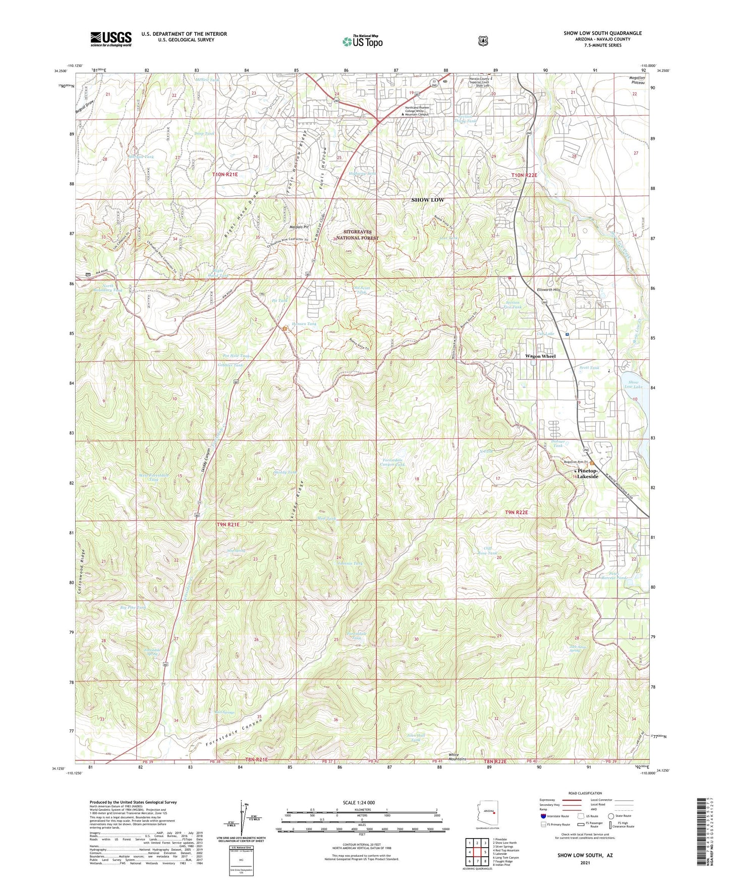
Show Low South Arizona US Topo Map
Couldn't load pickup availability
Also explore the Show Low South Forest Service Topo of this same quad for updated USFS data
2021 topographic map quadrangle Show Low South in the state of Arizona. Scale: 1:24000. Based on the newly updated USGS 7.5' US Topo map series, this map is in the following counties: Navajo. The map contains contour data, water features, and other items you are used to seeing on USGS maps, but also has updated roads and other features. This is the next generation of topographic maps. Printed on high-quality waterproof paper with UV fade-resistant inks.
Quads adjacent to this one:
West: Red Top Mountain
Northwest: Pinedale
North: Show Low North
Northeast: Silver Springs
East: Lakeside
Southeast: Indian Pine
South: Faught Ridge
Southwest: Long Tom Canyon
This map covers the same area as the classic USGS quad with code o34110b1.
Contains the following named places: Big Pine Tank, Calvary Baptist Church, Camp Grace, Camp Tatiyee, Camptown Mobile Home Park, Church of Our Saviour, Cliff Rose Tank, Cottonwood Ridge, Cub Lake, Deep Tank, Dohner Tank, Ellsworth Hills, Fools Hollow Ridge, Forestdale Canyon, Forestdale Canyon Tank, Forestdale Spring, Forestdale Tank, Forestdale Trading Post, Gobbler Tank, Grace Evangelical Lutheran Church, Hansen Tank, Highway Tank, Hiway Tank, Immanuel Lutheran Church, Jack Amos Spring, Jacques Dam, John Hall Tank, Johnnie Tank, Josephine Goldwater Hospital, Kingdom Hall of Jehovahs Witnesses, KVWM-AM (Show Low), KVWM-FM (Show Low), Lost Tank, Malpais Pit, McNeil Tank, Morgan Tank, Mud Tank, N Tank, Navapache Regional Medical Center Heliport, North Boundary Tank, Northland Pioneer College, Northland Pioneer College White Mountain Campus, Northland Pioneer College White Mountain Campus Cosmetology Building, Northland Pioneer College White Mountain Campus Goldwater Center, Northland Pioneer College White Mountain Campus Learning Center, Northland Pioneer College White Mountain Campus Ponderosa Center, Old Scott Tank, Park Pineway Plaza Shopping Center, Penrod Commerce Center, Petes Retreat Pond, Pine Shadows Mobile Home Park, Pine Shadows Travel Trailer Park, Pit Tank, Pot Hole Tank, Right Hand Tank, Ruin Springs, Saint Anthony School, Saint Rita Catholic Church, Saint Rita's Catholic Church, Scott Tank, Section Five Tank, Section Thirty Tank, Seep Spring, Show Low City Park, Show Low Lake, Show Low Library, Show Low Post Office, Skiddy Canyon, Skiddy Ridge, Skiddy Tank, Summit Healthcare Regional Medical Center, Tall Pines Care and Rehabilitation Center, Teorreon Golf Club, Timber Mesa Fire Department and Medical Station 14, Wagon Wheel Census Designated Place, Wagon Wheel Substation, Waltner's Mountain Crest Recreational Vehicle Resort, West Forestdale Tank, White Mountain Bible Church, White Mountains