MyTopo
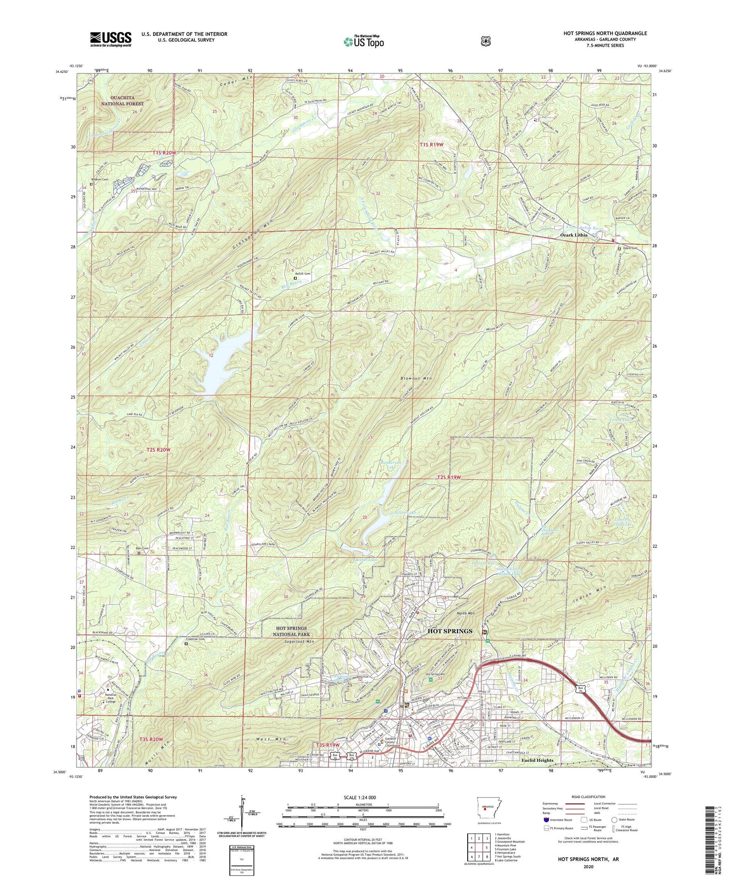
Hot Springs North Arkansas US Topo Map
Couldn't load pickup availability
Also explore the Hot Springs North Forest Service Topo of this same quad for updated USFS data
2024 topographic map quadrangle Hot Springs North in the state of Arkansas. Scale: 1:24000. Based on the newly updated USGS 7.5' US Topo map series, this map is in the following counties: Garland. The map contains contour data, water features, and other items you are used to seeing on USGS maps, but also has updated roads and other features. This is the next generation of topographic maps. Printed on high-quality waterproof paper with UV fade-resistant inks.
Quads adjacent to this one:
West: Mountain Pine
Northwest: Hamilton
North: Jessieville
Northeast: Goosepond Mountain
East: Fountain Lake
Southeast: Lake Catherine
South: Hot Springs South
Southwest: Hempwallace
This map covers the same area as the classic USGS quad with code o34093e1.
Contains the following named places: 18th East Judicial District Drug Task Force, Alternative Learning Environment School, Bain Cemetery, Bathhouse Row, Belvedere Country Club, Belvedere Country Club Lake Dam, Beth Jacob Hall, Bethel Dam, Bethel Lake, Big Chalybeate Spring, Big Chalybeate Springhouse, Blowout Mountain, Bonanza Springs, Bull Bayou, Central Baptist Church, Church of Christ, Church of God, Como Square, Congregational House of Israel, Country Club Lake, Crabtree Cemetery, Desoto Lake, DeSoto Park, Desoto Park Dam, Dillon Dam, Dillon Lake, Douglas School, East Side Church, East Side Pentecostal Church, Euclid Heights, Federal Bureau of Investigation Hot Springs Office, First Church of Christ Scientist, First Church of God, First Pentecostal Church, First United Methodist Church, Fordyce Bathhouse Vistor Center, Forest Lake, Forest Lake Dam, Fountain Lake Fire Department Station 2, Garland County Community College, Garland County Courthouse, Garland County Landfill, Garland County Public Library, Garland County Sheriff's Office, Glazypeau Mountain, Goldstein School, Grand Avenue United Methodist Church, Gulpha Gorge Campground, Gulpha Gorge Picnic Grounds, Hot Springs, Hot Springs Central Avenue Historical District, Hot Springs City Hall, Hot Springs Fire Department - Station 3 - Park Avenue, Hot Springs Fire Department Central Station, Hot Springs Junior High School, Hot Springs Mountain, Hot Springs National Park, Hot Springs Park Post Office, Hot Springs Police Department, Hot Springs Rehabilitation Center, Hot Springs Rehabilitation Center Hospital, Hot Springs Reservoir, Indian Mountain, KBMB-FM (Hot Springs), Kingdom Hall of Jehovahs Witnesses, KSBC-FM (Hot Springs), Langston High School, Langston Magnet School, Lee School, Leo N Levi National Arthritis Hospital, Libby Memorial Physical Medical Center, Lifenet Emergency Medical Services, Linden Park, Lower Dam Number One, Lower Dam Number Two, McGill Cemetery, Mid-America Park, Middle Branch Gulpha Creek, Middle Dam, Morning Star Church, Mount Zion African Methodist Episcopal Church, Mountain Valley Baptist Church, Mowray-Wyatt Plaza Shopping Center, Music Mountain, National Baptist Sanatarium, New Bethel Church, North Mountain, Ouachita Hospital, Ozark Cemetery, Ozark Lithia, Park Elementary School, Park Place Baptist Church, Piney Fire Department Station 1, Pullman Heights United Methodist Church, Ramble School, Ricks Dam, Ricks Estate Dam, Ricks Lake, Ricks Pond, Roanoke Baptist Church, Robbins Cemetery, Rosewood Convalescent Center, Saint Gabriels School, Saint Johns Catholic Church, Saint Johns School, Saint Joseph Hospital, Saint Lukes Episcopal Church, Saint Mary Baptist Church, Saint Marys Episcopal Church, Saint Marys Roman Catholic Church, Saint Michaels School, Sanderson Dam, Sanderson Lake, Second Baptist Church, Second Baptist School, Sharon Seventh Day Adventist Church, Sleepy Valley Lake, Sleepy Valley Lower Lake, Sleepy Valley Middle Lake, Sugarloaf Mountain, Summit School, Temple Pentecostal Church, The Gorge, The Gospel Temple, The Old Country Church, Tigert Memorial Methodist Church, Township of Union, Union Baptist Church, United States Forest Service - Ouachita National Forest (Park Security), United States National Park Service Park Security, Upper Dam, Wade Park, Walnut Valley Church, West Mountain, Wheatley Plaza Shopping Center, White Sulphur Springs, Whittington Park, Whittington Spring