MyTopo
Leslie Arkansas US Topo Map
Couldn't load pickup availability
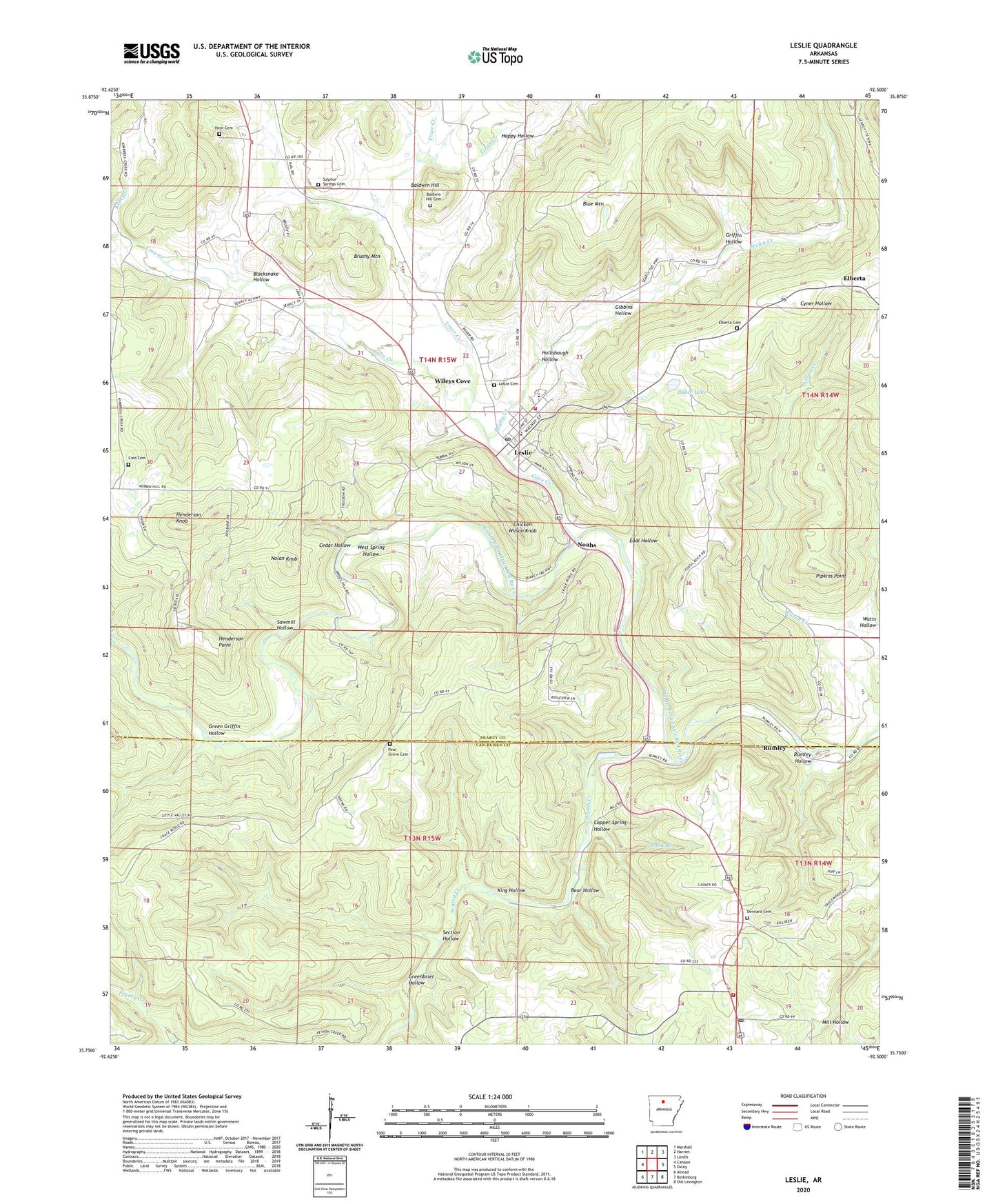
2024 topographic map quadrangle Leslie in the state of Arkansas. Scale: 1:24000. Based on the newly updated USGS 7.5' US Topo map series, this map is in the following counties: Searcy, Van Buren. The map contains contour data, water features, and other items you are used to seeing on USGS maps, but also has updated roads and other features. This is the next generation of topographic maps. Printed on high-quality waterproof paper with UV fade-resistant inks.
Quads adjacent to this one:
West: Canaan
Northwest: Marshall
North: Harriet
Northeast: Landis
East: Oxley
Southeast: Old Lexington
South: Botkinburg
Southwest: Alread
This map covers the same area as the classic USGS quad with code o35092g5.
Contains the following named places: Ashley Mill, Baker Lake, Baker Lake Dam, Baldwin Hill, Baldwin Hill Cemetery, Bear Hollow, Begley Creek, Blacksnake Hollow, Blue Mountain, Brushy Mountain, Caid Cemetery, Cedar Hollow, Chicken Wilson Knob, Church of Christ, City of Leslie, Copper Spring Hollow, Cove Creek, Dennard, Dennard Cemetery, Dennard Church, Dennard Post Office, Dennard School, Dennard Volunteer Fire Department, Eadl Hollow, Elberta, Elberta Cemetery, Gibbins Hollow, Green Griffin Hollow, Greenbrier Hollow, Griffin Hollow, Happy Hollow, Henderson Knob, Henderson Point, Hollabaugh Hollow, Horn Cemetery, Kelley Creek, Kimbrell Creek, King Hollow, Leslie, Leslie Cemetery, Leslie Fire Department, Leslie High School, Leslie Intermediate School, Leslie Post Office, Little Creek, New Hopewell Church, Noahs, Nolan Knob, Oak Flat, Peyton Creek, Pine Grove Cemetery, Pipkins Point, Poole Branch, Rumley, Rumley Hollow, Sawmill Hollow, Section Hollow, Sulphur Springs Cemetery, Township of Wileys Cove, Trace Creek, Watts Hollow, West Spring Hollow, Wileys Cove, ZIP Code: 72645