MyTopo
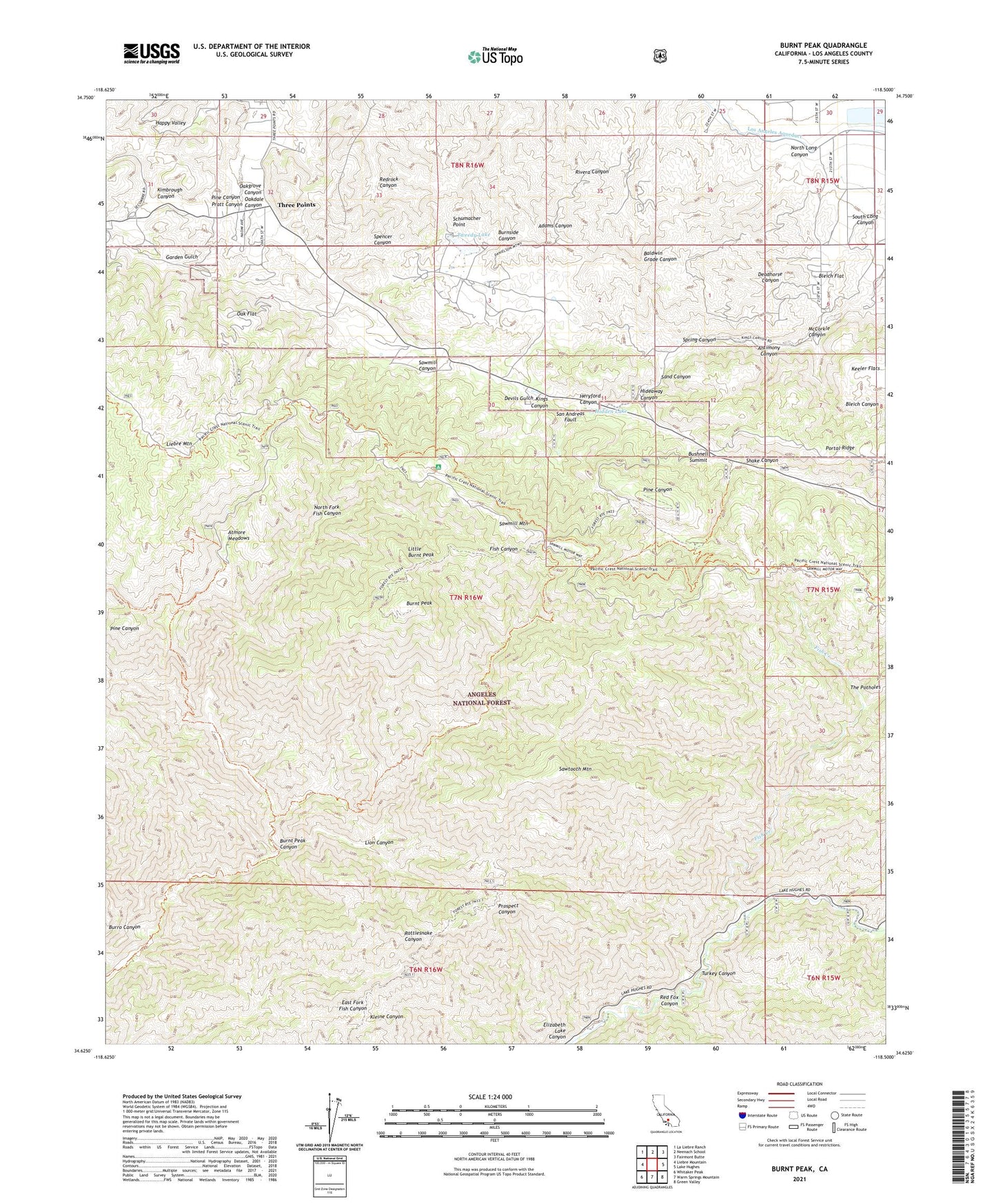
Burnt Peak California US Topo Map
Couldn't load pickup availability
Also explore the Burnt Peak Forest Service Topo of this same quad for updated USFS data
2021 topographic map quadrangle Burnt Peak in the state of California. Scale: 1:24000. Based on the newly updated USGS 7.5' US Topo map series, this map is in the following counties: Los Angeles. The map contains contour data, water features, and other items you are used to seeing on USGS maps, but also has updated roads and other features. This is the next generation of topographic maps. Printed on high-quality waterproof paper with UV fade-resistant inks.
Quads adjacent to this one:
West: Liebre Mountain
Northwest: La Liebre Ranch
North: Neenach School
Northeast: Fairmont Butte
East: Lake Hughes
Southeast: Green Valley
South: Warm Springs Mountain
Southwest: Whitaker Peak
This map covers the same area as the classic USGS quad with code o34118f5.
Contains the following named places: Antimony Canyon, Atmore Meadows, Atmore Meadows Campground, Big Chief Mine, Bleich Flat, Burnt Peak, Burnt Peak Canyon, Burnt Peak Trail, Bushnell Summit, Cottonwood Campground, Deadhorse Canyon, Deer Lodge, Devils Gulch, Fish Canyon Trail, Fish Creek, Garden Gulch, Gillette Mine Trail, Heryford Canyon, Hidden Lake, Hidden Lake Ranch, Hideaway Canyon, Kimbrough Canyon, Kings Canyon Percolation Basin, Kings Canyon Ranch, Lion Canyon, Little Burnt Peak, Lower Shake Campground, Maxwell Mine, McCorkle Canyon, North Fork Fish Canyon, North Long Canyon, Oak Flat, Oakdale Canyon, Oakgrove Canyon, Pine Canyon Ranger Station, Pine Canyon School, Pine Store, Portal Ridge, Pratt Canyon, Red Fox Canyon, Redrock Canyon, Sand Canyon, Sawmill Campground, Sawmill Canyon, Sawmill Mountain, Sawmill Mountain Ranch, Sawtooth Mountain, Schumacher Point, Shake Canyon, South Long Canyon, Spring Canyon, The Potholes, Three Points, Timberline Meadows Resort, Turkey Canyon, Tweedy Lake, Tweedy Lake Club, Upper Shake Campground, ZIP Code: 93532