
MyTopo
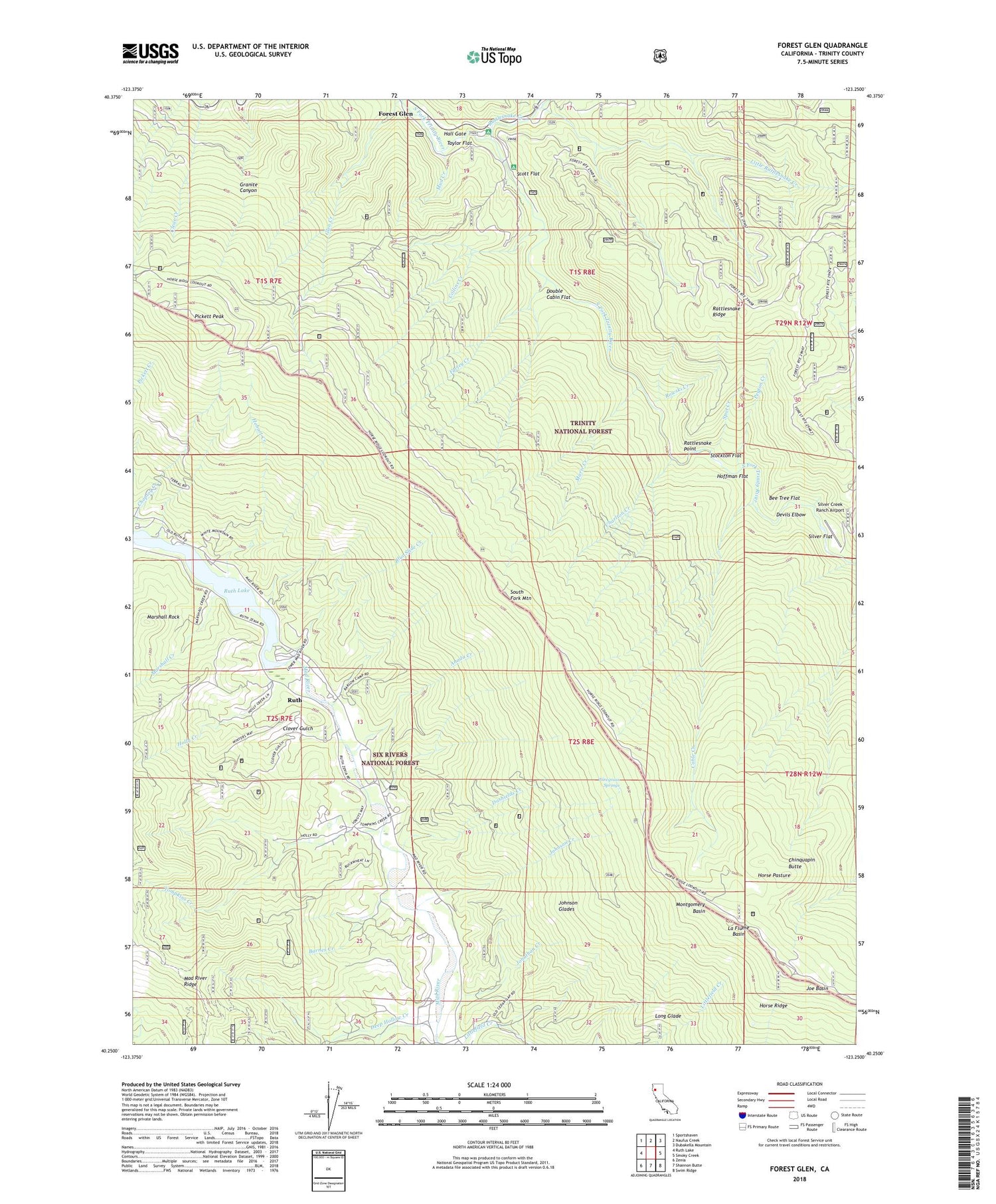
Forest Glen California US Topo Map
Couldn't load pickup availability
Also explore the Forest Glen Forest Service Topo of this same quad for updated USFS data
2022 topographic map quadrangle Forest Glen in the state of California. Scale: 1:24000. Based on the newly updated USGS 7.5' US Topo map series, this map is in the following counties: Trinity. The map contains contour data, water features, and other items you are used to seeing on USGS maps, but also has updated roads and other features. This is the next generation of topographic maps. Printed on high-quality waterproof paper with UV fade-resistant inks.
Quads adjacent to this one:
West: Ruth Lake
Northwest: Sportshaven
North: Naufus Creek
Northeast: Dubakella Mountain
East: Smoky Creek
Southeast: Swim Ridge
South: Shannon Butte
Southwest: Zenia
This map covers the same area as the classic USGS quad with code o40123c3.
Contains the following named places: Anada Creek, Barnes Creek, Bee Tree Flat, Blue Slide Creek, Cable Creek, Charlton Creek, Chinquapin Butte, Choptoy Creek, Clover Gulch, Collins Creek, Cutler Thicker, Dashields Creek, Deep Hollow Creek, Devils Elbow, Double Cabin Flat, Farley Creek, Fern Campground, Flume Gulch, Forest Glen, Forest Glen Post Office, Glen Creek, Hall Gate, Hell Gate Recreation Site, Hobart Creek, Hobart Creek Recreation Site, Hoffman Flat, Holly Creek, Horse Pasture, Horse Ridge, Horse Ridge Lookout, Joe Basin, Johnson Creek, Johnson Glades, Jonathan Creek, La Flume Basin, Little Rattlesnake Creek, Long Glade, Marie Creek, Marshall Creek, Marshall Rock, Montgomery Basin, Mud Creek, Norgaar Family Cemetery, Peyton Creek, Pickett Peak, Pickett Peak Campground, Pickett peak Lookout, Rattlesnake Creek, Rattlesnake Point, Rough Gulch Trail, Rowski Creek, Ruth, Ruth Census Designated Place, Ruth Hayfork Trail, Scott Flat, Silver Creek Ranch Airport, Silver Flat, South Fork Mountain, Southern Trinity Area Rescue Substation, Spot Creek, Stockton Flat, Taylor Flat, Terral Ranch, Tompkins Creek, Wiregrass Springs


