
MyTopo
Lake Isabella North California US Topo Map
Couldn't load pickup availability
Also explore the Lake Isabella North Forest Service Topo of this same quad for updated USFS data
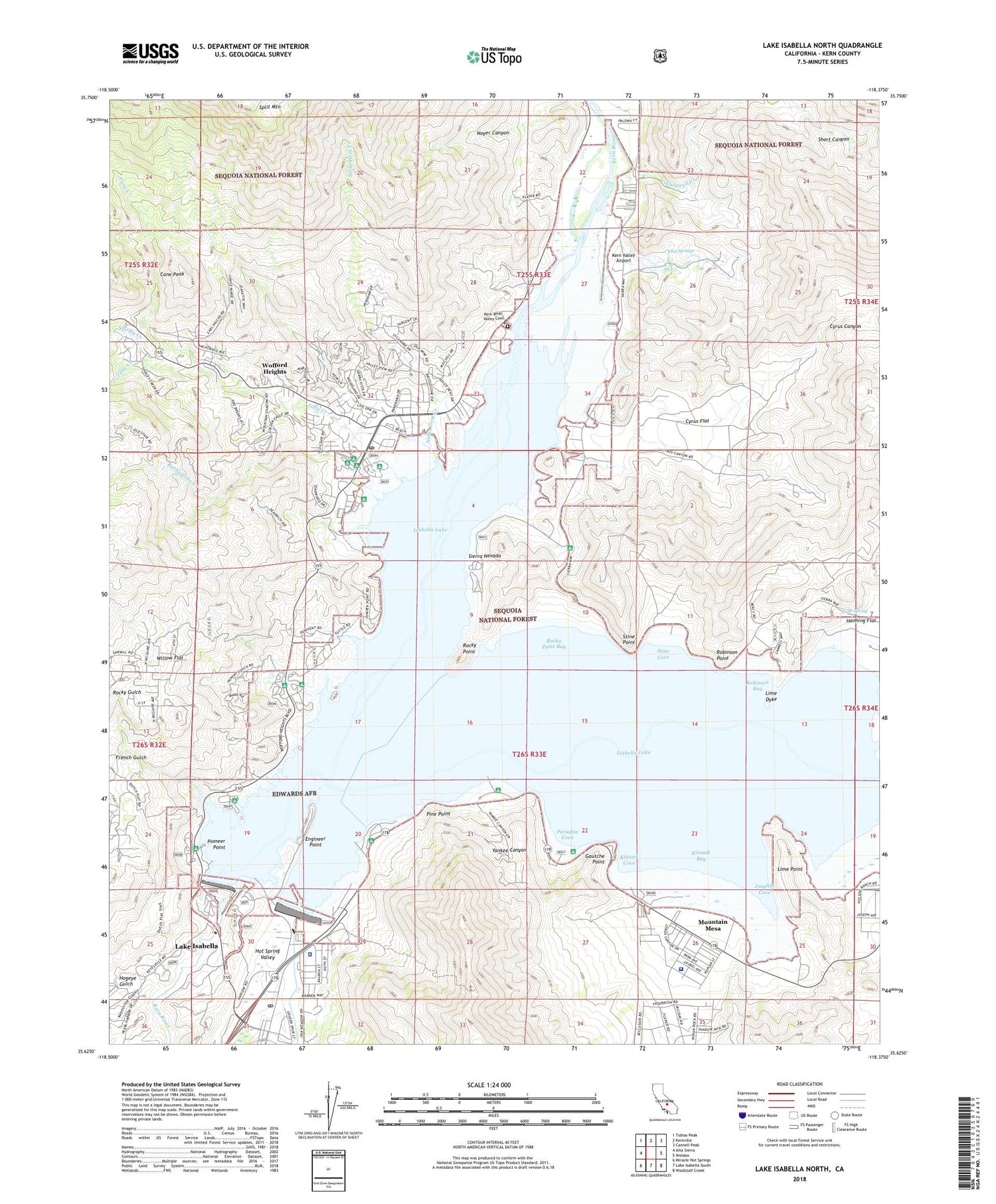
2022 topographic map quadrangle Lake Isabella North in the state of California. Scale: 1:24000. Based on the newly updated USGS 7.5' US Topo map series, this map is in the following counties: Kern. The map contains contour data, water features, and other items you are used to seeing on USGS maps, but also has updated roads and other features. This is the next generation of topographic maps. Printed on high-quality waterproof paper with UV fade-resistant inks.
Quads adjacent to this one:
West: Alta Sierra
Northwest: Tobias Peak
North: Kernville
Northeast: Cannell Peak
East: Weldon
Southeast: Woolstalf Creek
South: Lake Isabella South
Southwest: Miracle Hot Springs
This map covers the same area as the classic USGS quad with code o35118f4.
Contains the following named places: Auxiliary Dam Campground, Big Blue Mill, Big Blue Mine, Boulder Gulch Campground, Caldwell Creek, Camp Nine, Cane Creek, Cane Peak, Cane Spring, Commonwealth Mine, Cyrus Canyon, Cyrus Flat, Doyle Ranch, East Side Camp Ground, East Side Launch Ramp, Engineer Point, Freear Park, French Gulch, French Gulch Lake Patrol Station, French Gulch Marina, Gautche Point, Grandad Mine, Hogeye Gulch, Hot Springs, Hungry Gulch Campground, Isabella, Isabella Auxiliary Dam, Isabella Lake, Isabella Main Dam, Isabella Marina Number Two, Isabella Point Boat Ramp, Joughin Cove, Kern County Airport, Kern County Sheriff's Office, Kern River Valley Cemetery, Kern Valley Airport, Kern Valley Hospital, Kern Valley Marina, Kernville, Kernville Heliport, Kissack Bay, Kissack Cove, Kissack Cove Boat Ramp, KVLI-AM (Lake Isabella), Lake Isabella Census Designated Place, Lake Isabella Post Office, Launch Area Number Nineteen, Launch Area Number Seventeen, Launch Area Number Two, Launch Ramp Number Sixteen, Lime Dyke, Lime Point, Live Oak Campground, Main Dam Campground, Mountain Mesa, Mountain Mesa Census Designated Place, Mountain Mesa Park, Nellie Dent Creek, North Fork Marina, Noyer Canyon, Paradise Cove, Paradise Cove Boat Ramp, Paradise Cove Campground, Pine Point, Pioneer Point, Pioneer Point Campground, Rattlesnake Creek, Raymond Mine, Regan Mine, Robinson Bay, Robinson Point, Rocky Point, Rocky Point Bay, Shirley Creek, Slippery Rock Picnic Area, South Fork Kern River, South Fork Picnic Area, Stine Cove, Stine Point, Tillie Creek, Tillie Creek Boat Ramp, Tillie Creek Campground, Willow Flat, Woffard Heights Post Office, Wofford Heights, Wofford Heights Census Designated Place, Wofford Heights Park, Woodford Ranch, Yankee Canyon, ZIP Code: 93238


