MyTopo
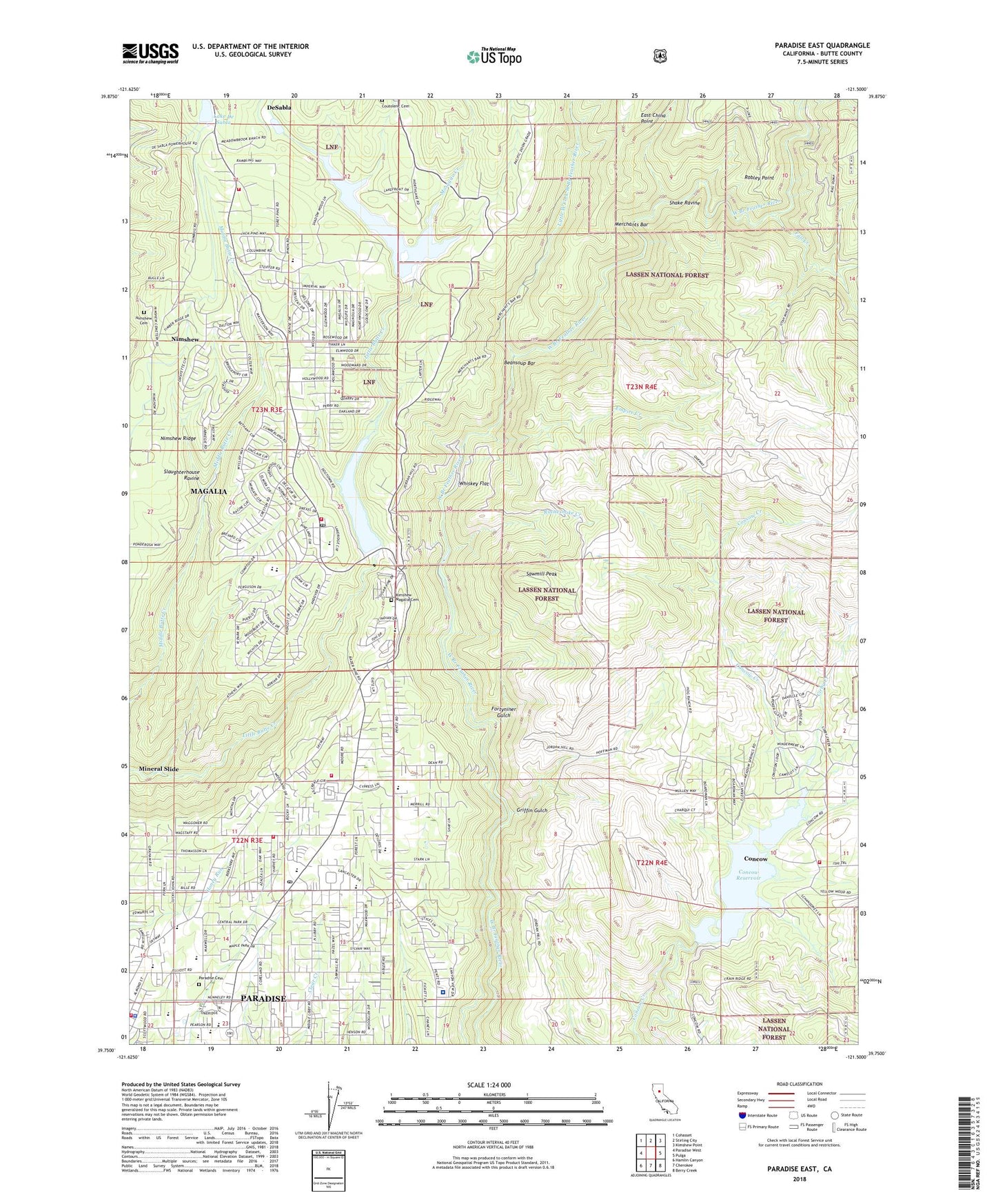
Paradise East California US Topo Map
Couldn't load pickup availability
Also explore the Paradise East Forest Service Topo of this same quad for updated USFS data
2022 topographic map quadrangle Paradise East in the state of California. Scale: 1:24000. Based on the newly updated USGS 7.5' US Topo map series, this map is in the following counties: Butte. The map contains contour data, water features, and other items you are used to seeing on USGS maps, but also has updated roads and other features. This is the next generation of topographic maps. Printed on high-quality waterproof paper with UV fade-resistant inks.
Quads adjacent to this one:
West: Paradise West
Northwest: Cohasset
North: Stirling City
Northeast: Kimshew Point
East: Pulga
Southeast: Berry Creek
South: Cherokee
Southwest: Hamlin Canyon
This map covers the same area as the classic USGS quad with code o39121g5.
Contains the following named places: Beansoup Bar, Butte County Fire Department Station 31, Butte County Fire Department Station 33, Butte County Fire Department Station 38, California Department of Forestry and Fire Protection Station 35 Paradise, Calvary Baptist Church, Cirby Creek, Concow 67 Dam, Concow Census Designated Place, Concow Reservoir, Cory Mine, Coutolenc, Coutolenc Cemetery, Crain Memorial Park, De Sabla, DeSabla, Desabla Forebay 97-005 Dam, East China Point, Emma Mine, Empire Creek, Fall Creek, Feather River Hospital, First Assembly of God Church, First Baptist Church, First Responder Emergency Medical Services Station 11, First Responder Emergency Medical Services Station 12, Fortyniner Gulch, Foursquare Gospel Church, Genil Mine, Griffin Gulch, Historic Pioneer Church, I Am Temple, Jubilee on the Ridge Church, Junior Academy, Kimshew Magalia Cemetery, Lake De Sabla, Little West Fork West Branch Feather River, Madre de Oro Mine, Magalia, Magalia 73 Dam, Magalia Camp, Magalia Census Designated Place, Magalia Community Church, Magalia Mine, Magalia Post Office, Magalia Reservoir, Merchants Bar, Mineral Slide, Mosquito Creek, New Life Apostolic Church, Nimshew, Nimshew Cemetery, Nimshew Ridge, Old Utah Mine, Orofino Mine, Our Savior Lutheran Church, Paradise, Paradise 73-002 Dam, Paradise Branch Butte County Library, Paradise Cemetery, Paradise Christian Church, Paradise Christian School, Paradise Church of Religious Science, Paradise Community Church of the Brethren, Paradise Elementary School, Paradise Fire Department Station 1, Paradise Fire Department Station 3, Paradise High School, Paradise Holiness Church, Paradise Intermediate School, Paradise Lake, Paradise Lake Recreation Site, Paradise Lutheran Church, Paradise Memorial Park, Paradise Pines, Paradise Police Department, Paradise Post Office, Paradise Ridge Southern Baptist Church, Pine Ridge Elementary School, Ponderosa Elementary School, Rattlesnake Creek, Ridgeview High School, Robley Point, Saint Nicholas Episcopal Church, Saint Thomas More Catholic Church, Saint Thomas More School, Sawmill Peak, Shake Ravine, Slaughterhouse Ravine, Steifer Mine, The Church of Jesus Christ of Latter Day Saints, Town of Paradise, Veterans Memorial Hall, Whiskey Flat