MyTopo
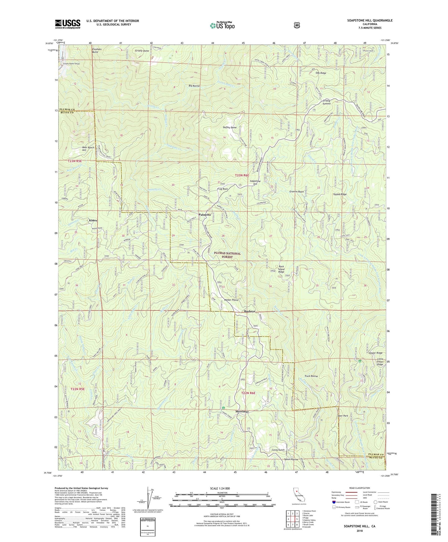
Soapstone Hill California US Topo Map
Couldn't load pickup availability
Also explore the Soapstone Hill Forest Service Topo of this same quad for updated USFS data
2022 topographic map quadrangle Soapstone Hill in the state of California. Scale: 1:24000. Based on the newly updated USGS 7.5' US Topo map series, this map is in the following counties: Plumas, Butte. The map contains contour data, water features, and other items you are used to seeing on USGS maps, but also has updated roads and other features. This is the next generation of topographic maps. Printed on high-quality waterproof paper with UV fade-resistant inks.
Quads adjacent to this one:
West: Pulga
Northwest: Kimshew Point
North: Storrie
Northeast: Bucks Lake
East: Haskins Valley
Southeast: Cascade
South: Brush Creek
Southwest: Berry Creek
This map covers the same area as the classic USGS quad with code o39121g3.
Contains the following named places: Baker Creek, Bear Ranch Hill, Big Ravine, Boulder Creek, Buckeye, Clear Creek, Daniel Zink Campground, Deer Park, Duffey Dome, Elks Retreat, Foreman Creek, Four Trees, Fox Creek, French Hotel Creek, Frog Rock, Glazer Creek, Gold Lake, Granite Basin, Grizzly Creek, Grizzly Dome, Grizzly Dome Tunnel, Grizzly Summit, Haphazard Creek, Happy Hollow Creek, Jordan Creek, Kister, Letter Box, Little Glazer Ridge, Little North Fork Campground, Little Rody Creek, Lucky Jack Mine, Lucky Laddie Mine, Merrimac, Oak Ridge, Palmetto, Palmetto Creek, Rock Island Ridge, Rody Creek, Rogers Cow Camp, Silver Star Mine, Soapstone Creek, Soapstone Hill, Soapstone Mine, Toland Creek, Toland Ridge, Truck Ravine, Walker Plains, West Branch French Creek, Wildcat Creek