MyTopo
Woodside California US Topo Map
Couldn't load pickup availability
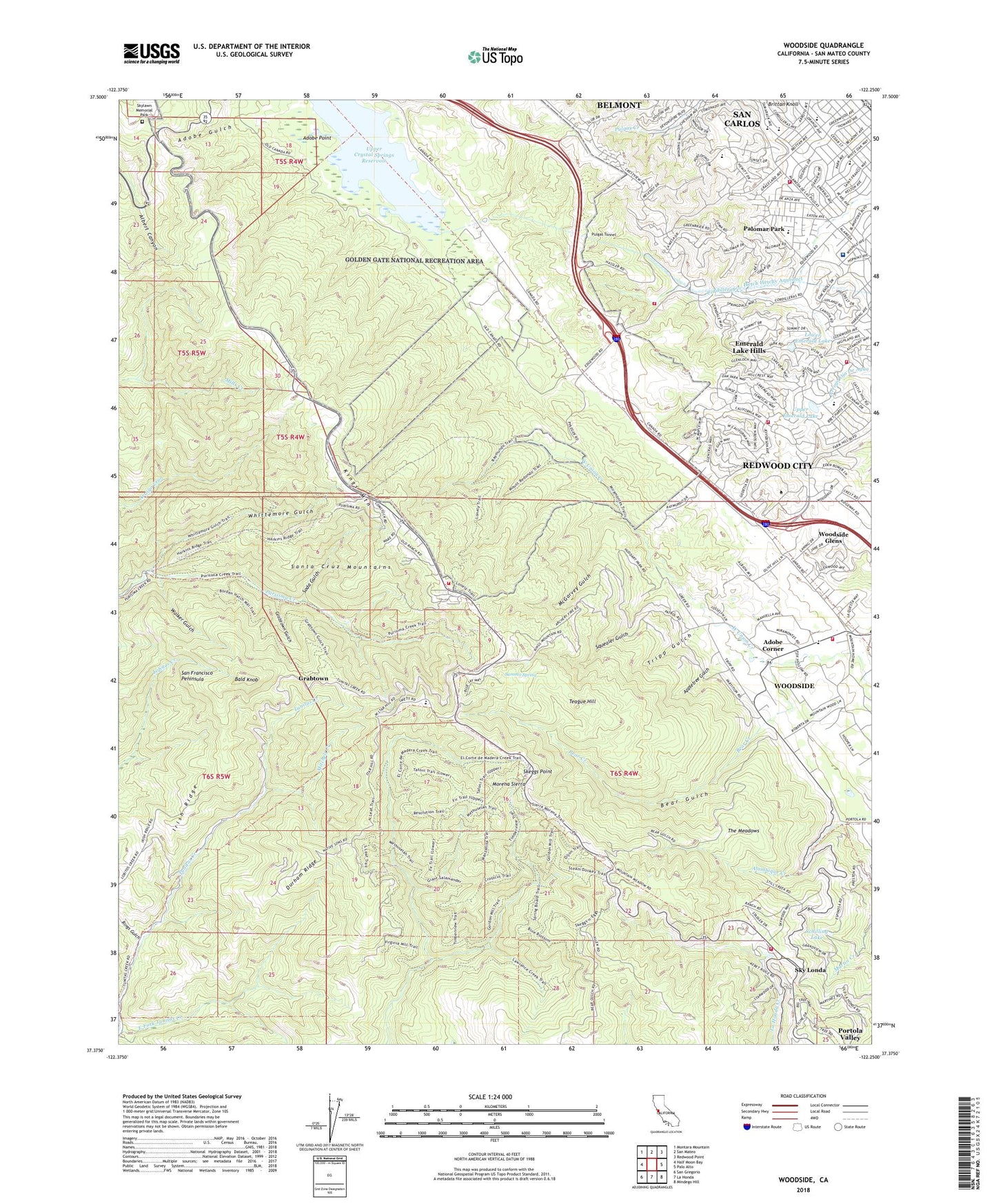
2021 topographic map quadrangle Woodside in the state of California. Scale: 1:24000. Based on the newly updated USGS 7.5' US Topo map series, this map is in the following counties: San Mateo. The map contains contour data, water features, and other items you are used to seeing on USGS maps, but also has updated roads and other features. This is the next generation of topographic maps. Printed on high-quality waterproof paper with UV fade-resistant inks.
Quads adjacent to this one:
West: Half Moon Bay
Northwest: Montara Mountain
North: San Mateo
Northeast: Redwood Point
East: Palo Alto
Southeast: Mindego Hill
South: La Honda
Southwest: San Gregorio
This map covers the same area as the classic USGS quad with code o37122d3.
Contains the following named places: Adobe Corner, Adobe Gulch, Adobe Point, Alambique Trail, Allen Lookout, Appletree Gulch, Bald Knob, Bear Gulch, Big Canyon Park, Blue Oak Trail, Brittan Acres Elementary School, Brittan Knoll, California Department of Forestry and Fire Protection Station 58 Skylonda Fire Station, California Riding and Hiking Trail, Canada College, Canada De Raymundo, Canada Road 1-069 Dam, Carlmont Christian Center, City of San Carlos, Clarkia Trail, Clifford Elementary School, Community Shopping Center, Cordilleras Mental Health Center, Crestview Park, Dave Beeger Park, Department of Forestry and Fire Protection Station 18 Cordilleras Fire Station, Department of Forestry and Fire Station 58, Dignity Health - Sequoia Hospital, Durham Ridge, E R Burton Park, East Fork Tunitas Creek, Eaton Park, Edgewood County Park, Edgewood Trail, El Corte De Madera Open Space, Emerald Hills Golf Course, Emerald Lake, Emerald Lake 1 Lower 612 Dam, Emerald Lake Hills, Emerald Lake Hills Census Designated Place, Episcopal Church of the Epiphany, Farm Hills, Filoli Mansion and Gardens, Garrett Park, Grabtown, Grabtown Gulch, Heather Elementary School, Heather Park, Highland Park, Huddart Park, Irish Ridge, Kings Mountain, Kings Mountain Elementary School, Laguna Creek, Lower Emerald Lake, Lynda Lake 600 Dam, McGarvey Gulch, Meadow Trail, Mitchell Creek, Morena Sierra, Mount Alverno Convent, Old Stage Day Camp, Old Woodside Store, Palomar Park, Peninsula Covenant Church, Pise Lookout, Pulgas Ridge Open Space Preserve, Pulgas Tunnel, Pulgas Water Temple, Pursima Creek Redwoods Open Space, Redwood City Fire Department Station 12, Redwood Park, Ridgeview Loop Trail, Rings Gulch, Roy Cloud School, Saint Charles Catholic Church, Saint Charles School, Saint Matthais School, San Carlos Fire Department Station 16, San Mateo County, Schilling Lake, Sequoia Hospital Health Sciences Library, Serpentine Loop Trail, Skeggs Point, Sky Londa, Skylawn Memorial Park, Soda Gulch, Squealer Gulch, Summit Spring, Sylvan Trail, Teague Hill, Teague Hill Open Space Preserve, The Church of Jesus Christ of Latter Day Saints, The Meadows, Thornewood Open Space Preserve, Town of Woodside, Tripp Gulch, Upper Crystal Springs Reservoir, Upper Emerald Lake, Walker Gulch, West Union Creek, White Oaks Elementary School, Whittemore Gulch, Woodside, Woodside Branch San Mateo County Library, Woodside City Hall, Woodside Elementary School, Woodside Fire Protection District Station 19, Woodside Fire Protection District Station 7, Woodside Glens, Wunderlich County Park, ZIP Codes: 94062, 94070