MyTopo
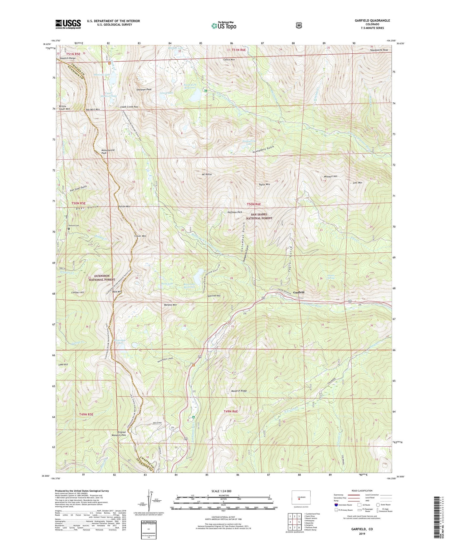
Garfield Colorado US Topo Map
Couldn't load pickup availability
Also explore the Garfield Forest Service Topo of this same quad for updated USFS data
2022 topographic map quadrangle Garfield in the state of Colorado. Scale: 1:24000. Based on the newly updated USGS 7.5' US Topo map series, this map is in the following counties: Chaffee, Gunnison. The map contains contour data, water features, and other items you are used to seeing on USGS maps, but also has updated roads and other features. This is the next generation of topographic maps. Printed on high-quality waterproof paper with UV fade-resistant inks.
Quads adjacent to this one:
West: Whitepine
Northwest: Cumberland Pass
North: Saint Elmo
Northeast: Mount Antero
East: Maysville
Southeast: Mount Ouray
South: Pahlone Peak
Southwest: Sargents
This map covers the same area as the classic USGS quad with code o38106e3.
Contains the following named places: Alaska Mine, Alpha and Beta Mine, Anna Huffman Copper Mine, April Fool Mine, Bald Mountain, Banana Mountain, Ben Bolts Paymaster Mine, Billings Lake, Black Tiger Mine, Bonnie Belle Mine, Boss Lake Dam, Boss Lake Reservoir, Brighton Mine, Brittle Silver Mountain, Burton Quarry, Calico Mountain, Chalk Creek Pass, Clinton Mine, Clover Mountain, Columbus Gulch, Columbus Mine, Contact Hill, Cyclone Creek, Darling Mine, Deer Gulch, Delaware Mine, Desdemona Mine, Eclipse Mine, Elkington Mine, Evening Star Mine, Fairplay Mine, Flora Belle Mine, Fooses Creek Trail, Fort Scott Gulch, Fraction Mine, French Quarry, Garfield, Garfield Campground, Garfield Census Designated Place, Garfield Mine, Giant Eclipse Mine, Golden Age Mine, Grand Monarch Mine, Great Monarch Mine, Half Moon Mine, Hancock Lake, Hancock Pass, Hawkeye Number One Mine, Hawkeye Number Three Mine, Hawkeye Number Two Mine, Hermit Springs, Hoffman Park, Hunkydory Gulch, Hunkydory Lake, Hunt Lake, Indianapolis Mine, Irishwood Esther Mine, Iron Duke Mine, Island Lake, Jennings Creek, Jewell Tunnel Mine, Josephine Number One Quarry, Kangaroo Gulch, Lake Hill, Last Chance Mine, Lilly Mine, Lily Mine, Little Charm Mine, Little Wonder Mine, Lost Mountain, Madonna Mine, Major Mine, Mason Mine, McCoy Creek, Middle Fork South Arkansas River, Missouri Boy Mine, Missouri Hill, Monarch, Monarch Lime Quarry, Monarch Park Campground, Monarch Ski Area, Monongahela Mine, Monumental Peak, Moss Flower Mine, Mount Aetna, Mountain Chief Mine, New York Mine, North Fooses Creek, North Fork Campground, North Fork Dam, North Fork Reservoir, Ohio and Morningstar Mine, Original Monarch Pass, Oshkosh Mine, Page Mine, Paymaster Mine, Pilgrim Group Mine, Pinyon Mine, Rainbow-Eagle Bird Mine, Robbins Creek, Sewanee Peak, Shamrock Mine, Shavano, Silent Friend Mine, Silver King Mine, Song Bird Mine, South Fooses Creek, South Quartz Creek Mine, Syncline Hill, Taylor Gulch, Taylor Mountain, Thirty-six-thirty Mine, Tomichi Cemetery, Upper Hancock Lake, Van Wirt Mountain, Vulcan Mountain, Waterdog Lakes, Wilson Mine, ZIP Code: 81227