
MyTopo
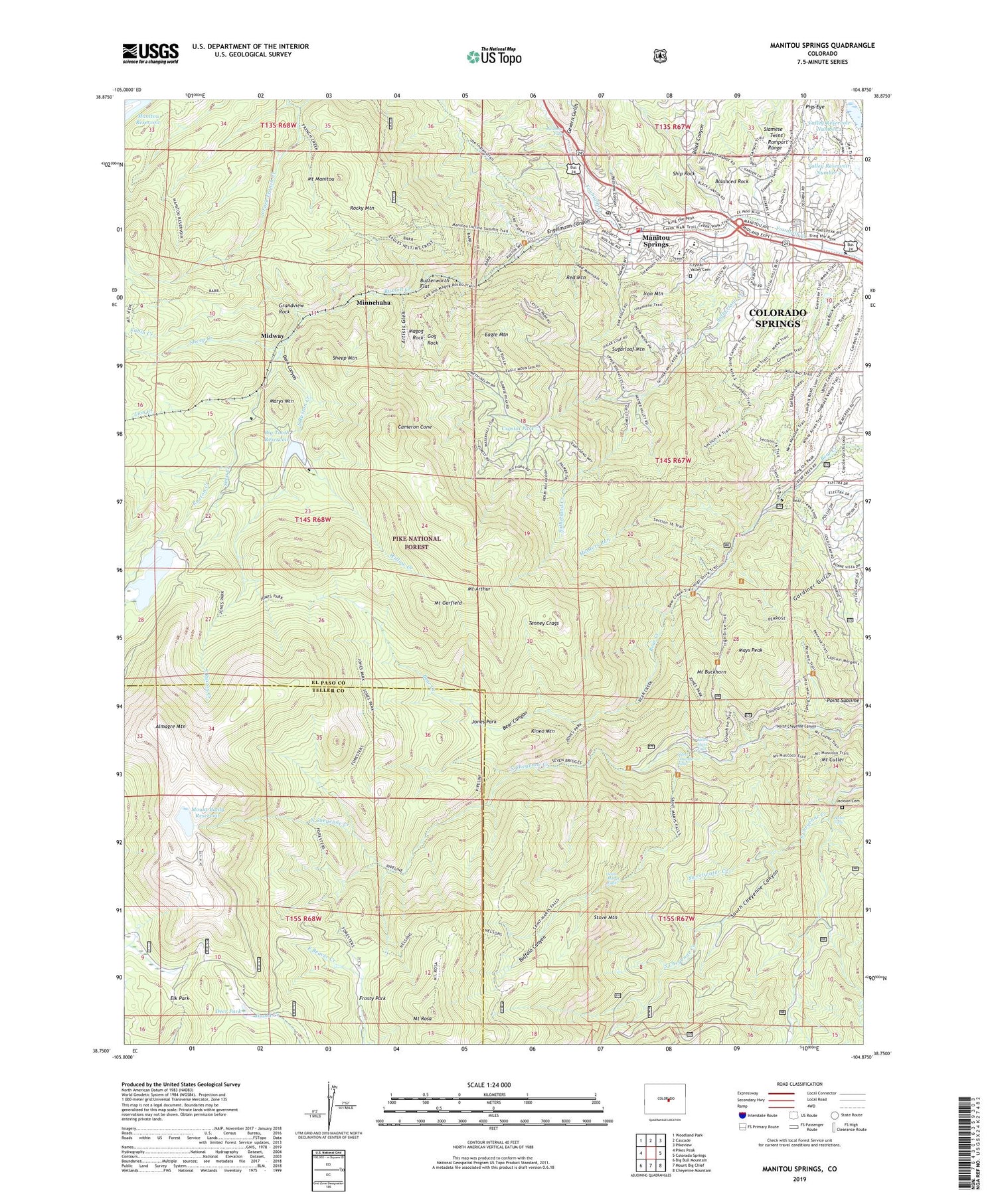
Manitou Springs Colorado US Topo Map
Couldn't load pickup availability
Also explore the Manitou Springs Forest Service Topo of this same quad for updated USFS data
2022 topographic map quadrangle Manitou Springs in the state of Colorado. Scale: 1:24000. Based on the newly updated USGS 7.5' US Topo map series, this map is in the following counties: El Paso, Teller. The map contains contour data, water features, and other items you are used to seeing on USGS maps, but also has updated roads and other features. This is the next generation of topographic maps. Printed on high-quality waterproof paper with UV fade-resistant inks.
Quads adjacent to this one:
West: Pikes Peak
Northwest: Woodland Park
North: Cascade
Northeast: Pikeview
East: Colorado Springs
Southeast: Cheyenne Mountain
South: Mount Big Chief
Southwest: Big Bull Mountain
This map covers the same area as the classic USGS quad with code o38104g8.
Contains the following named places: Almagre Mountain, Artists Glen, Balanced Rock, Bear Canyon, Big Tooth Reservoir, Big Tooth Reservoir Dam, Black Canyon, Bock Pit, Buffalo Canyon, Butterworth Flat, Cabin Creek, Cameron Cone, Cavern Gulch, Cheyenne Mountain School Cabin, City of Manitou Springs, Clemet Cabin, Crystal Park, Crystal Valley Cemetery, Dark Canyon, Deer Park, Dorothy O Claim, Duffields Mine, Eagle Mountain, Engelmann Canyon, Eureka Tunnel Mine, Frosty Park, Garden of the Gods, Gardiner Gulch, Gog Rock, Grandview Rock, Green Settlement, Helen Hunt Falls, High Park, Hunters Run, Indian Trail, Iron Mountain, Jackson Cemetery, Jones Park, Kineo Mountain, KXRE-AM (Manitou Springs), Lake Moraine, Lake Moraine Dam, Lion Creek, Magog Rock, Manitou Reservoir, Manitou Springs, Manitou Springs Elementary School, Manitou Springs Fire Department, Manitou Springs High School, Manitou Springs Middle School, Manitou Springs Police Department, Manitou Springs Post Office, Marys Mountain, Mays Peak, Midway, Minnehaha, Mount Arthur, Mount Baldy Dam, Mount Buckhorn, Mount Cutler, Mount Garfield, Mount Manitou, Mount Rosa, Neeper Cabin, Nelson Camp, North Cheyenne Park, North Fork French Creek, Old Mountain View, Palmer Trail, Penrose Trail, Pigs Eye, Pikes Peak Division, Point Sublime, Rainbow Falls, Red Mountain, Rocky Mountain, Ruxton Creek, Ruxton Park, Saint Marys Falls, Saint Peters Dome Pegmatite Prospect, Seep Creek, Seven Falls, Sheep Creek, Sheep Mountain, Ship Rock, Siamese Twins, Silver Cascade Falls, South Fork French Creek, South Ruxton Creek, Stove Mountain, Stove Mountain Claims, Stratton Reservoir, Sugarloaf Mountain, Sutherland Creek, Sweetwater Creek, Tenney Crags, Valley Reservoir Number 1, Valley Reservoir Number 2, Wheeler Pit, Williams Canyon, Willow Creek, ZIP Codes: 80829, 80904, 80906


