MyTopo
Fairmount Delaware US Topo Map
Couldn't load pickup availability
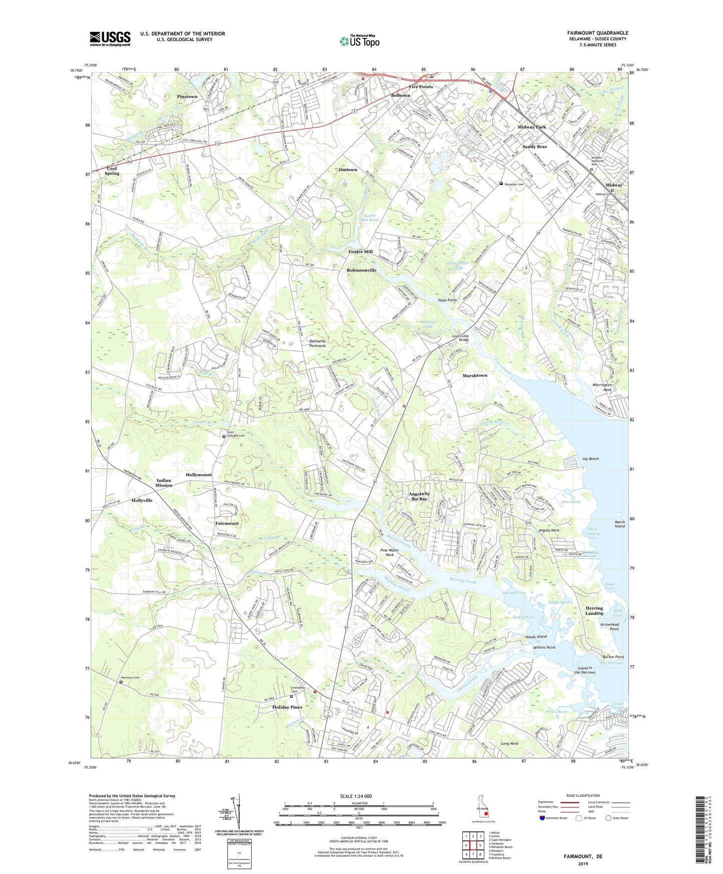
2023 topographic map quadrangle Fairmount in the state of Delaware. Scale: 1:24000. Based on the newly updated USGS 7.5' US Topo map series, this map is in the following counties: Sussex. The map contains contour data, water features, and other items you are used to seeing on USGS maps, but also has updated roads and other features. This is the next generation of topographic maps. Printed on high-quality waterproof paper with UV fade-resistant inks.
Quads adjacent to this one:
West: Harbeson
Northwest: Milton
North: Lewes
Northeast: Cape Henlopen
East: Rehoboth Beach
Southeast: Bethany Beach
South: Frankford
Southwest: Millsboro
This map covers the same area as the classic USGS quad with code o38075f2.
Contains the following named places: Angola, Angola Acres II Mobile Home Park, Angola Beach Mobile Home Park, Angola by the Bay, Angola Crest II Mobile Home Park, Angola Crest Mobile Home Park, Angola Grange, Angola Landing, Angola Neck, Angola Neck Park Mobile Home Park, Arabian Acres, Arbre Park Mobile Home Park, Arnell Creek, Arrowhead Point, Aspen Meadows, Bay City Mobile Home Park, Bay Shore Hills, Baywood Greens Golf Course, Beaver Dam Acres, Belltown, Ben Robins Landing, Black Duck Point, Bookhammer Landing, Breezewood, Bundicks Branch, Burton Point, Burton Pond, Burton Pond Dam, Burton Prong, Carpenters Corner, Chapel Branch, Cherry Walk Creek, Colonial East Mobile Home Park, Conley Chapel Village Mobile Home Park, Conrad Middle School, Cool Spring, Cool Spring Farms Mobile Home Park, Cool Spring Grange, Cool Spring Presbyterian Church, Country Village, Cozy Cove Airport, Cozy Cove Mobile Home Park, Danfield Acres, Delaware State Police Troop 7, Dorman Branch, Drawbridge School, Ebenezer Cemetery, Enchanted Acres Mobile Home Park, Fairmount, Fisher Landing, Five Points, Fox Hollow, Friendship Cemetery, Friendship School, Friendship United Methodist Church, Goslee Creek, Goslee Mill, Goslee Mill Pond, Goslee Mill Pond Dam, Greens Landing, Guinea Creek, Harmony Cemetery, Hazard Cove, Herring Creek, Herring Creek Estates, Herring Landing, Hetty Fisher Glade, Hetty Fisher Pond, Holiday Pines, Holiday Pines Mobile Home Park, Holly Lake Campground, Holly Pines Mobile Home Park, Hollymount, Hollyville, Hollyville Acres, Hoods Island, Hopkins Prong, Horse Island, Indian Mission, Indian Mission Cemetery, Indian Mission Church, Indian River Hundred, Indian River Volunteer Fire Company Station 2, Island in the Narrows, Israel Church, Jimtown, John Marsh Landing, Joshua Fisher House, Joy Beach, Leisure Point Mobile Home Park, Lewes and Rehoboth Fire Station 3, Lewes and Rehoboth Hundred, Lewes Fire Department Station 2, Lingo Cove, Lingo Estate Mobile Home Park, Lochwood, Log Cabin Mobile Home Park, Long Acres, Long Neck, Long Neck Church, Long Neck Shopping Center, Long Neck Village Mobile Home Park, Love Creek, Love Creek Bridge, Mallard Point, Maplewood, Marsh Island, Marsh Island Golf Course, Marshtown, Martin Branch, Massey Marsh, Mastens Heights Mobile Home Park, Mid Sussex Rescue Squad, Midway, Midway Asembly of God Church, Midway Baptist Church, Midway Cemetery, Midway Church, Midway Estates, Midway Park, Midway Presbyterian Church, Midway Shopping Center, Nanticoke Crossing Shopping Center, Nanticoke Indian Tribe State Designated Tribal Statistical Area, Nanticoke Shores Mobile Home Park, Nassau Park Mobile Home Park, Nassau Post Office, Nassau School, Oak Forest Mobile Home Park, Old Landing, Old Landing Golf Course, Old Landing Woods, Peddlers Village Shopping Center, Peoples Memorial Park, Phillips Branch, Pine Valley Mobile Home Park, Pine Water Farm, Pine Water Landing, Pine Water Neck, Pinetown, Pot Hook Creek, Pots Nets North Mobile Home Park, Rabbits Ferry School, Red Mill Farms, Rehoboth Aircrafters Airport, Rehoboth Mall Shopping Center, Rehoboth Shores Mobile Home Park, Robinson Landing, Robinsonville, Saint Georges Cemetery, Saint Georges Church, Sally Burton Ponds, Sally Cove, Sandy Brae, Sarah Run, Sea Farers Village, Sea Spray Village, Seventh Day Adventist Church, Shawns Hideaway Mobile Home Park, Sheep Pen Landing, Shell Landing, Shell Landing Cove, Sherwood Forest Mobile Home Park, Shops at Long Neck Shopping Center, Short Marsh, Sipps Point, Sloan Cove, Sloan Landing, Stillman Glade, The Landing, The Narrows, The Plantations, The Willows, The Woods on Herring Creek, Tri-State Mobile Home Park, Truitts Midway Development, Unity Branch, Wall Branch, Warrington Neck, Webb Landing, Welches Pond, West Bay Park Mobile Home Park, WGMD Radio Tower, WGMD-FM (Rehoboth Beach), Wilkins Point, William Ritter Manor, Wilson Creek, Wilson Marsh, Winding Creek Village, Wolfpit Marsh, Wolfpit Pond, Woods Edge, ZIP Code: 19958