
MyTopo
Lewes Delaware US Topo Map
Couldn't load pickup availability
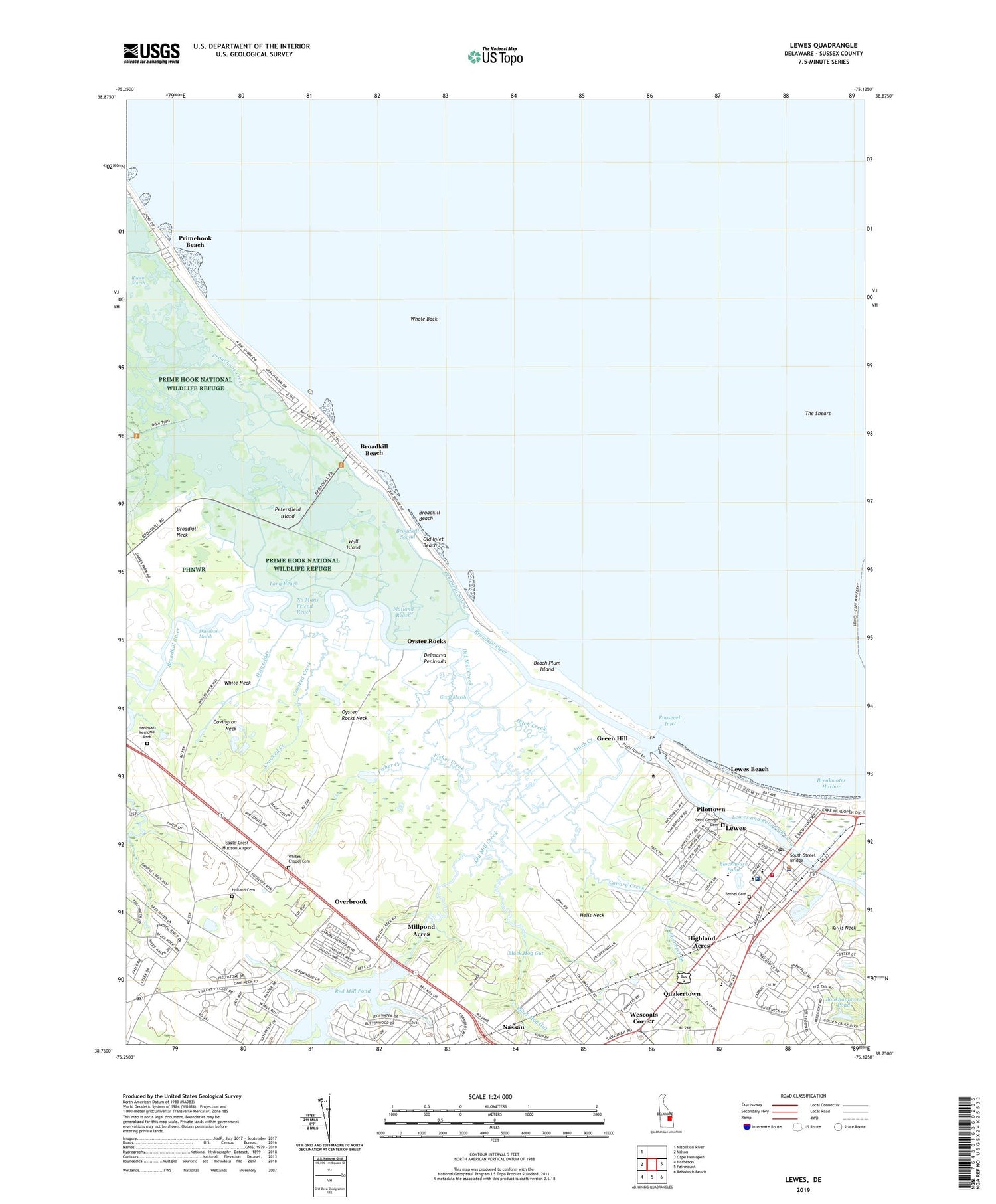
2023 topographic map quadrangle Lewes in the state of Delaware. Scale: 1:24000. Based on the newly updated USGS 7.5' US Topo map series, this map is in the following counties: Sussex. The map contains contour data, water features, and other items you are used to seeing on USGS maps, but also has updated roads and other features. This is the next generation of topographic maps. Printed on high-quality waterproof paper with UV fade-resistant inks.
Quads adjacent to this one:
West: Milton
Northwest: Mispillion River
East: Cape Henlopen
Southeast: Rehoboth Beach
South: Fairmount
Southwest: Harbeson
This map covers the same area as the classic USGS quad with code o38075g2.
Contains the following named places: Beach Plum Island, Beach Plum Island State Park, Beebe Hospital School of Nursing, Beebe Medical Center, Bethel Cemetery, Bethel United Methodist Church, Black Hog Gut, Black Hog Landing, Blockhouse Pond, Bookhammers Pond, Broadkill Beach, Broadkill Hundred, Broadkill River, Broadkill Sound, Burtons Chapel, Canary Creek, Cape Henlopen Junior High School, Capes Cove Mobile Home Park, Carsylian Acres, City of Lewes, Covey Creek, Covington Neck, Cripple Creek, Crooked Creek, Davidson Marsh, Ditch Creek, Donovan Development, Doty Glade, Dutch Acres, Eagle Crest-Hudson Airport, East Mill Run, Ebenezer Branch, Edgewater, First Baptist Church of Lewes, Fisher Creek, Flatland Reach, Friendship Church, Great Marsh, Green Hill, Groome United Methodist Church, Hazzard Landing, Hells Neck, Henlopen Memorial Park, Heronwood, Highland Acres, Holland Cemetery, Holland Pond, Houston, Lewes, Lewes Beach, Lewes City Hall, Lewes City Power Plant, Lewes Fire Department Station 1 Headquarters, Lewes Junior High School, Lewes Pit, Lewes Police Department, Lewes Post Office, Lewes Presbyterian Church, Lewes Public Library, Lewes Sewage Treatment Plant, Long Reach, Maulls Wharf, McNichol Place, Mill Creek Manor, Mill Pond Acres, Millpond Acres, Murrays Corner, Nassau, No Mans Friend Reach, North Jetty Light, Old Inlet Beach, Old Mill Creek, Overbrook, Overbrook Shores, Oyster Rocks, Oyster Rocks Neck, Petersfield Ditch, Petersfield Island, Pilottown, Plumb Point, Primehook Beach, Primehook Creek, Quakers Heights, Quakertown, Red Hill Manor, Red Mill Pond, Red Mill Pond Dam, Richard A Shields Elemantary School, Roach Marsh, Robertson Landing, Roosevelt Inlet, Saint George Cemetery, Saint Jude the Apostle Church, Saint Peters Church, Sand Dunes Village, Savannah Place, Shady Side, Shaffer Property, Shell Beach Pond, South Jetty Light, South Street Bridge, Star Landing, Steamboat Landing, Swanendael, Sweet Briar Mobile Home Park, The Shears, University of Delaware College of Earth Ocean and Environment Lewes Campus, Wall Island, Wescoats Corner, Whale Back, White Neck, Whites Chapel, Whites Chapel Cemetery, Wiltbank Landing, Zwaanendael Museum


