
MyTopo
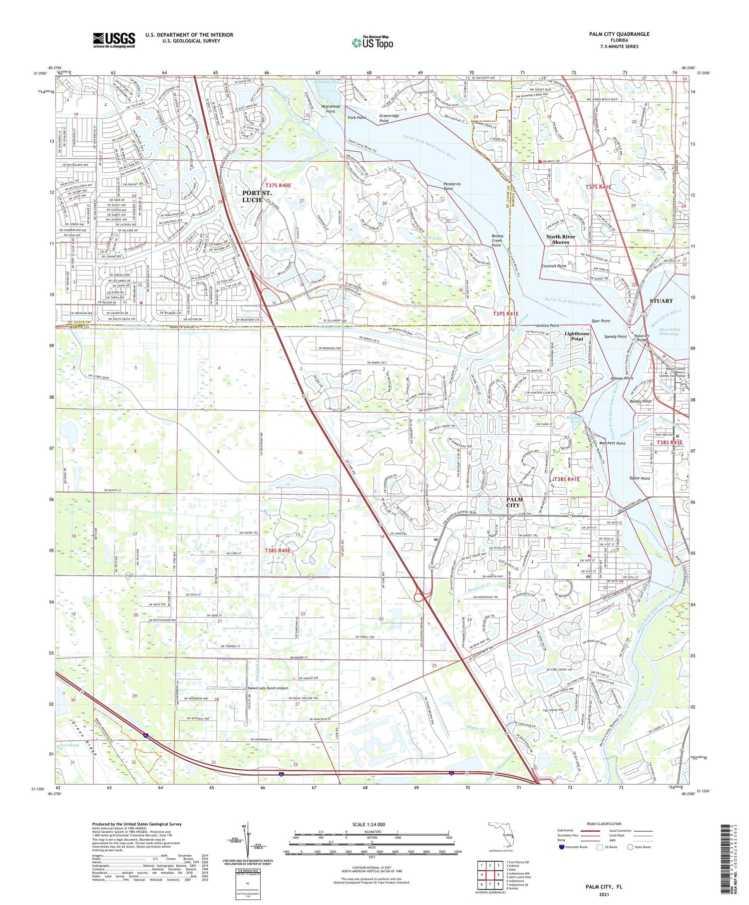
Palm City Florida US Topo Map
Couldn't load pickup availability
2024 topographic map quadrangle Palm City in the state of Florida. Scale: 1:24000. Based on the newly updated USGS 7.5' US Topo map series, this map is in the following counties: Martin, St. Lucie. The map contains contour data, water features, and other items you are used to seeing on USGS maps, but also has updated roads and other features. This is the next generation of topographic maps. Printed on high-quality waterproof paper with UV fade-resistant inks.
Quads adjacent to this one:
West: Indiantown NW
Northwest: Fort Pierce SW
North: Ankona
Northeast: Eden
East: Saint Lucie Inlet
Southeast: Gomez
South: Indiantown SE
Southwest: Indiantown
This map covers the same area as the classic USGS quad with code o27080b3.
Contains the following named places: Aldersgate United Methodist Church, Arbeau Point, Bessey Creek Point, Bessey Point, Bessy Creek, Blakeslee Creek, Britt Creek, Church of Christ at Palm City, Coconut Point, Danforth Creek, Dyer Point, Episcopal Church of the Advent, Fern Hill Cemetery, First Baptist Christian School, First Baptist Church of Stuart, First Congregational United Church of Christ of Palm City, Fork Point, Frazier Creek, Glendale Montessori School, Grace Presbyterian Church in America, Grapevine United Methodist Church, Greenridge Point, Highland Woods Golf and Country Club, Holy Redeemer Catholic Church, Howard Creek, Immanuel Lutheran Church, Jack-N-Jill Child Development Center, Jenkins Point, Jensen Beach Mall, Kingdom Hall of Jehovahs Witnesses, Kitching Cove, Leighton Park, Leisure Village Mobile Home Park, Lighthouse Point, Mapps Creek, Martin County Fire Rescue Station 18, Martin County Fire Rescue Station 21, Martin County Marina, Martin County Public Library System Hoke Branch Library, Matchett Point, Mile Lake, Naked Lady Ranch Airport, Negrohead Point, North Fork Saint Lucie River, North River Shores, North River Shores Census Designated Place, North Stuart Baptist Church, Palm City, Palm City Census Designated Place, Palm City Elementary School, Palm City Post Office, Palm City Presbyterian Church, Palm Lake Park, Pendarvis Cove, Pendarvis Point, Poppolton Creek, Riverwatch Marina, Rolling Hills Golf Club, Roosevelt Bridge, Rosen Shingle Creek Golf Club, Rotonda Golf snd Country Club, Royal Oak Resort and Golf Club, Royal Palm Country Club, Royal Palm Yacht and Country Club, Royal Poinciana Golf Club, Royal Tee Country Club, Saint Elizabeth Ann Seton Church, Saint Lucie County Fire District Station 13, Seagreen Marina, South Fork Saint Lucie River, Speedy Point, Stuart, Stuart Centre, Stuart Heritage Museum, Stuart Shopping Center, Stuart Southpoint Anchorage, Taylor Point, The Church of Jesus Christ of Latter Day Saints, Treasure Coast Presbyterian Church, Treasure Coast Square, Treasure Coast Square Mall, Union Church, WHLG-FM (Jensen Beach), Winters Creek, WSTU-AM (Stuart), ZIP Codes: 34984, 34990, 34994


