MyTopo
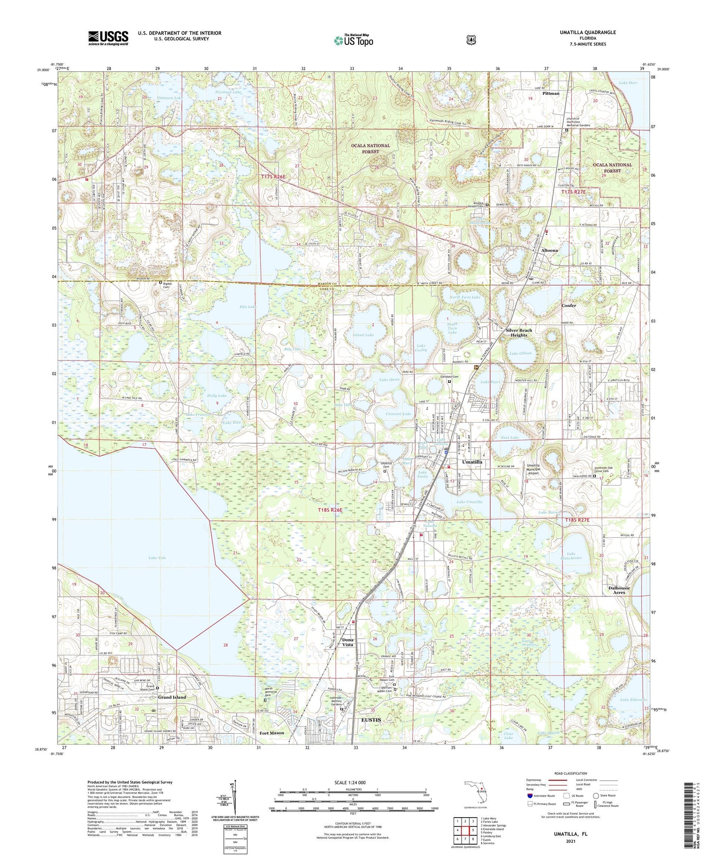
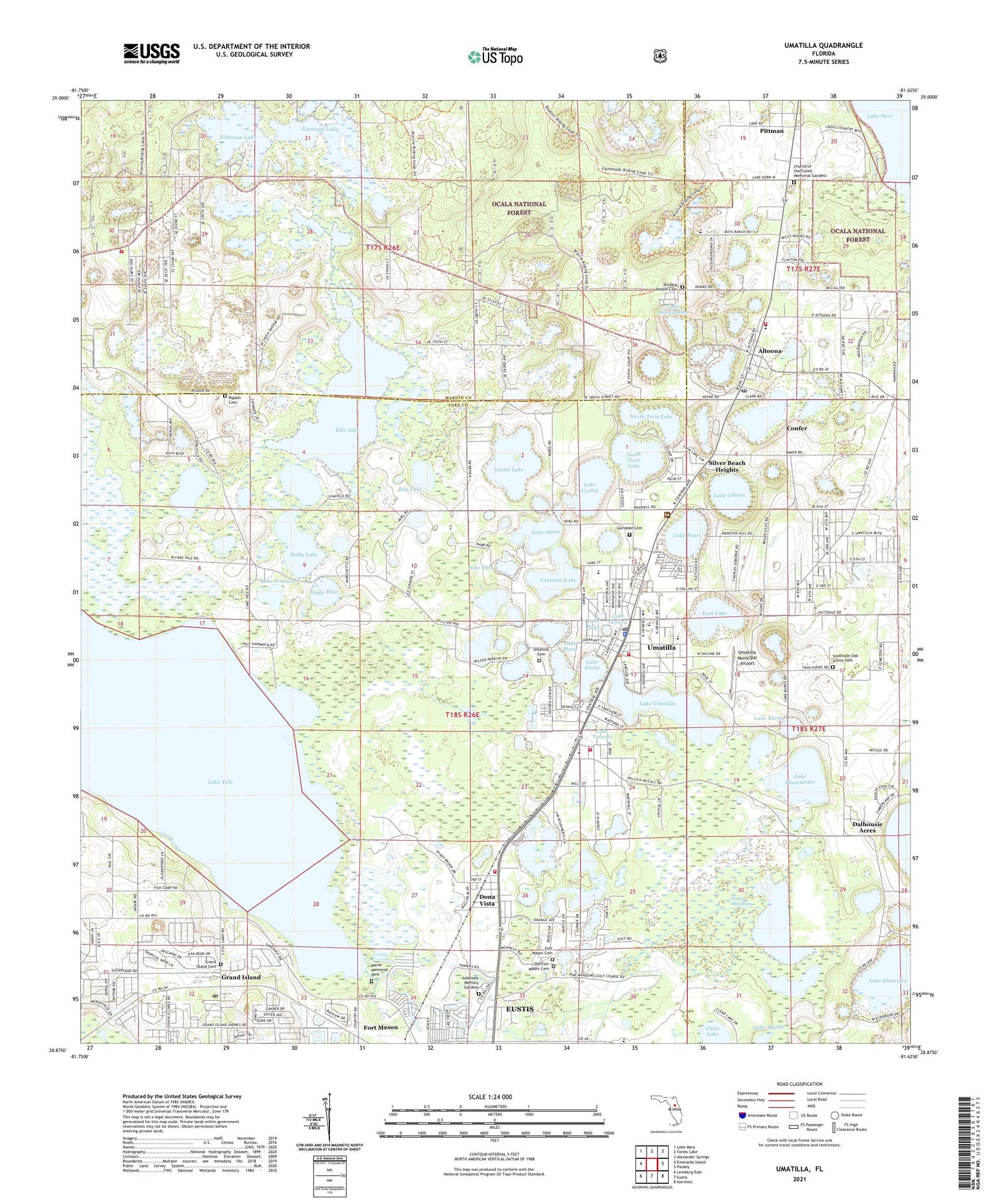
Umatilla Florida US Topo Map
Couldn't load pickup availability
Also explore the Umatilla Forest Service Topo of this same quad for updated USFS data
2024 topographic map quadrangle Umatilla in the state of Florida. Scale: 1:24000. Based on the newly updated USGS 7.5' US Topo map series, this map is in the following counties: Lake, Marion. The map contains contour data, water features, and other items you are used to seeing on USGS maps, but also has updated roads and other features. This is the next generation of topographic maps. Printed on high-quality waterproof paper with UV fade-resistant inks.
Quads adjacent to this one:
West: Emeralda Island
Northwest: Lake Mary
North: Farles Lake
Northeast: Alexander Springs
East: Paisley
Southeast: Sorrento
South: Eustis
Southwest: Leesburg East
This map covers the same area as the classic USGS quad with code o28081h6.
Contains the following named places: Alee Academy Charter School, Altoona, Altoona Census Designated Place, Altoona Hinson Cemetery, Altoona Post Office, Altoona School, Bay Lake, Bethel African Methodist Episcopal Church, City of Umatilla, Clear Lake, Collins Lake, Confer, Crescent Lake, Dalhousie Acres, Del - Aire Country Club, Dona Vista, Dona Vista Church, East Lake, Ella Lake, Emmanuel Church, Eustis Meadows, First Baptist Church of Altoona, First Baptist Church of Micco, First Baptist Church of Umatilla, First United Methodist Church of Umatilla, Florida Elks Harry-Anna Hospital, Fort Mason, Fountains Country Club, Glendale Cemetery, Golden Estates Mobile Home Park, Gospel Tabernacle, Grand Island, Grand Island Baptist Church, Grand Island Cemetery, Grand Island Mobile Home Park, Grand Island Post Office, Gurrant Park, Gwinn Cadwell Park, Harry-Anna School, Haselton Village Mobile Home Park, Holly Lake, Island Lake, Jerusalem Worship Center, Kingdom Hall of Jehovahs Witnesses, Lake Blanchester, Lake Bracy, Lake Burns, Lake Cooley, Lake County Fire Rescue Station 14, Lake County Fire Rescue Station 19 - Support Services, Lake County Fire Station Supply, Lake County Fire/Rescue Station 14, Lake Eldorado, Lake Elza, Lake Enola, Lake Frances, Lake Geneva, Lake Gibson, Lake Hospitality, Lake Mary, Lake Oleo, Lake Owen, Lake Palm, Lake Pearl, Lake Smith, Lake Tutuola, Lake Umatilla, Lake Whitcomb, Lake Yale, Lakeside Memory Gardens, Lakeview Terrace Water Tower, Lands Mobile Home Park, Liberty Lighthouse Church of God, Life Changing Church of God, Lisbon Substation-Progress Energy, Marion County Fire Rescue Rolling Woods Volunteer Station 29, Marsh Memorial Park, New Hope Missionary Baptist Church of Lake County, Nicatoon Lake Recreation Site, Nicotoon Lake, North Twin Lake, Old Fort Mason Cemetery, Olde Mill Stream Recreational Vehicle Park, Piney Grove Missionary Baptist Church, Pittman, Pittman Census Designated Place, Presbyterian Church USA, Rolling Woods Mobile Home Park, Sandy Acres Airport, Sandy Acres Baptist Church, Silver Beach Heights, South Twin Lake, Southside School, Tropical Whisper Mobile Home Park, Umatilla, Umatilla Cemetery, Umatilla Church of God, Umatilla City Hall, Umatilla Elementary School, Umatilla Fire Department, Umatilla High School, Umatilla High School Football Stadium, Umatilla Library, Umatilla Middle School, Umatilla Municipal Airport, Umatilla Police Department, Umatilla Post Office, Umatilla Substation-Progress Energy, Umatilla Water Tower, United Methodist Church of Altoona, Valley of Calvary Ministries, Victory Christian Center, ZIP Codes: 32735, 32784