MyTopo
Griffin North Georgia US Topo Map
Couldn't load pickup availability
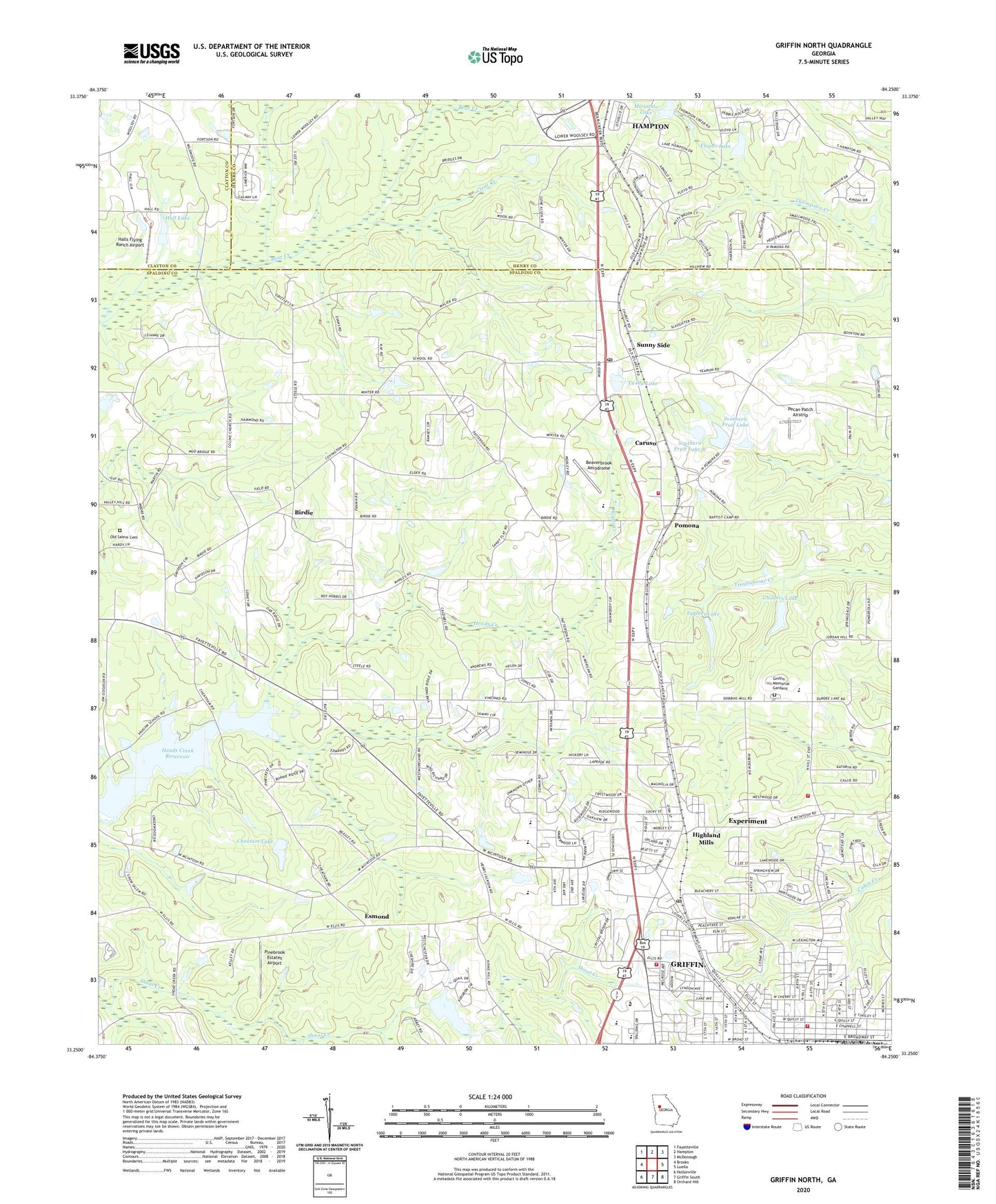
2024 topographic map quadrangle Griffin North in the state of Georgia. Scale: 1:24000. Based on the newly updated USGS 7.5' US Topo map series, this map is in the following counties: Spalding, Henry, Clayton. The map contains contour data, water features, and other items you are used to seeing on USGS maps, but also has updated roads and other features. This is the next generation of topographic maps. Printed on high-quality waterproof paper with UV fade-resistant inks.
Quads adjacent to this one:
West: Brooks
Northwest: Fayetteville
North: Hampton
Northeast: McDonough
East: Luella
Southeast: Orchard Hill
South: Griffin South
Southwest: Hollonville
This map covers the same area as the classic USGS quad with code o33084c3.
Contains the following named places: A Z Kelsey Academy, Atkinson Elementary School, Baptist Tabernacle, Beaverbrook Aerodrome, Beaverbrook Elementary School, Birdie, Burdett, Calvary Baptist Church, Caruso, Cheatam Lake, Cheatam Lake Dam, Childers Lake, Childers Lake Dam, Church of Christ, Church of God, Church of Prophecy, City of Sunny Side, Clear Creek, County Line Church, Cowan Road Elementary School, Cowan Road Middle School, Damascus Church, Devotie Baptist Church, Elementary Enrichment Center, Ellis Crossing Shopping Center, Esmond, Experiment, Experiment Census Designated Place, Experiment Post Office, Expressway Village Shopping Center, Fairmont School, Faith Baptist Church, Faith Temple Assembly of God Church, First Assembly of God Church, First Congregational Church, First Fellowship Church, Floyds Lake, Floyds Lake Dam, Flynt Middle School, Flynt Street Middle School, Grace Baptist Church, Grace Fellowship Church, Griffin Christian Academy and High School, Griffin Country Club, Griffin Division, Griffin Fire and Rescue Station 1, Griffin Fire and Rescue Station 2, Griffin Memorial Gardens, Griffin Spalding Alternative School, Griffin Technicial College, Hall Dam, Hall Lake, Halls Flying Ranch Airport, Heads Creek, Heads Creek Dam, Heads Creek Reservoir, Highland Baptist Church, Highland Mills, Highland Mills School, Jordan Hill Road Elementary School, Kelsey School, Kincaid Memorial United Methodist Church, Kincaid School, McIntosh Church, Miriatoto Lake, Miriatoto Lake Dam, Moore Elementary School, Mount Pleasant Baptist Church, North Griffin Square Shopping Center, Northgate Shopping Center, Northside School, Oak Hill Baptist Church, Old Salem Cemetery, Orrs Elementary School, Pecan Patch Airstrip, People Church, Pinebrook Estates Airport, Pirkle Campground, Pomona, Pomona Baptist Church, Pomona United Methodist Church, Providence Baptist Church, Red Oak Church, Sacred Heart Catholic Church, Second Baptist Church, Seventh Day Adventist-Dickerson Church, Shoal Creek Lake, Shoal Creek Lake Dam, Southern Fruit Lake, Southern Fruit Lake B, Southern Fruit Lake Dam, Southern Fruit Lake Dam B, Spalding County, Spalding County Fire Department Station 4, Spalding County Fire Department Station 6, Spalding County Junior High School, Spalding Village Shopping Center, Sunny Side, Sunny Side Division, Sunny Side First Baptist Church, Sunny Side Post Office, Sunny Side School, Taylors Lake, Taylors Lake Dam, Twilly Lake, Twilly Lake Dam, United Church, Vineyard Baptist Church, Vineyard School, Vineyard Village Shopping Center, Wesleyan Methodist Church, West Griffin Holiness Church, West Griffin School, West Sunny Side Church, WGRI-AM (Griffin), Wildwood Church, Will of God Apostolic Church, ZIP Codes: 30223, 30284