
MyTopo
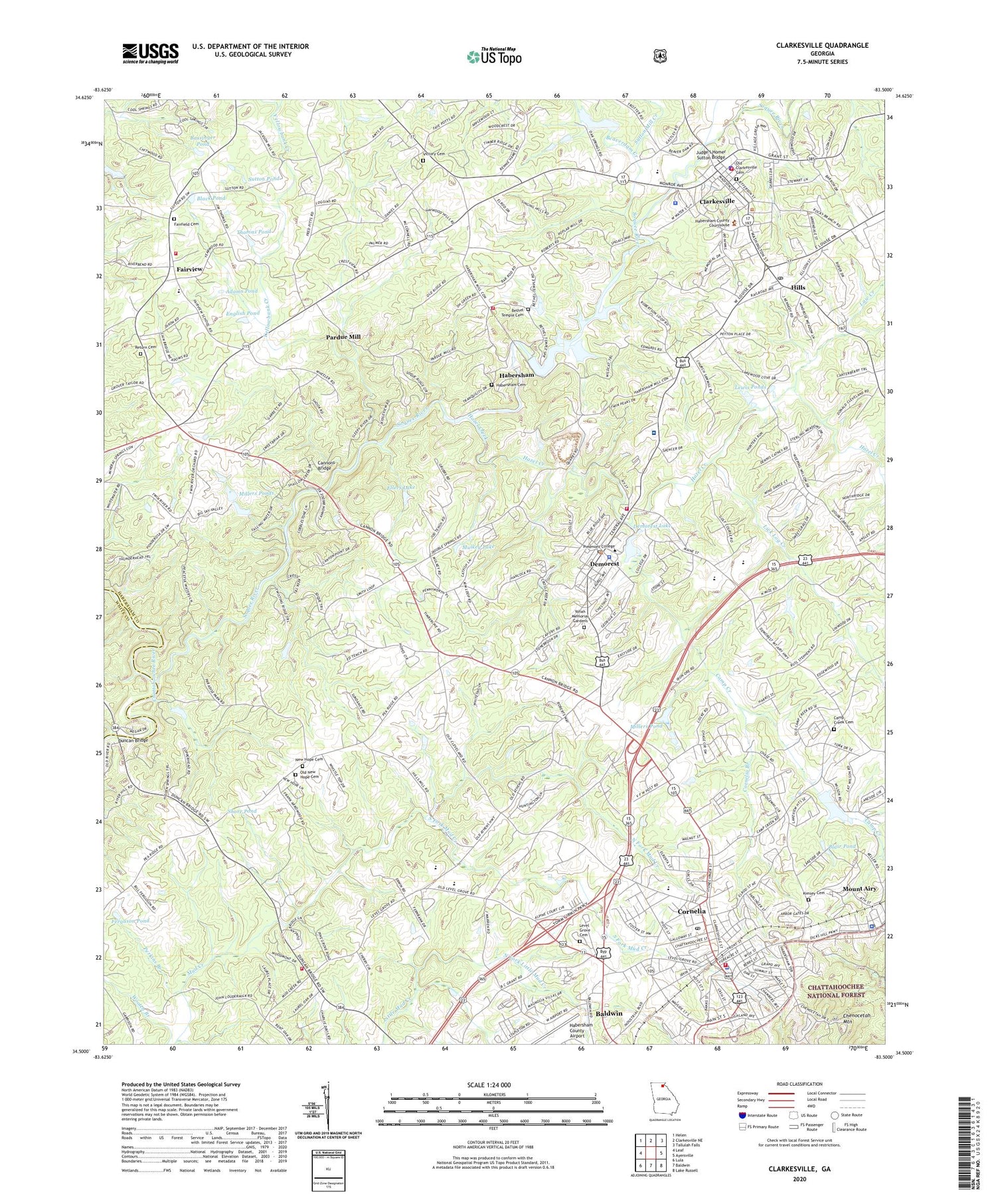
Clarkesville Georgia US Topo Map
Couldn't load pickup availability
Also explore the Clarkesville Forest Service Topo of this same quad for updated USFS data
2024 topographic map quadrangle Clarkesville in the state of Georgia. Scale: 1:24000. Based on the newly updated USGS 7.5' US Topo map series, this map is in the following counties: Habersham, White. The map contains contour data, water features, and other items you are used to seeing on USGS maps, but also has updated roads and other features. This is the next generation of topographic maps. Printed on high-quality waterproof paper with UV fade-resistant inks.
Quads adjacent to this one:
West: Leaf
Northwest: Helen
North: Clarkesville NE
Northeast: Tallulah Falls
East: Ayersville
Southeast: Lake Russell
South: Baldwin
Southwest: Lula
This map covers the same area as the classic USGS quad with code o34083e5.
Contains the following named places: Adams Pond, Barrett Pond, Bassinger Pond, Beaverdam Creek, Bert, Bethel Temple, Bethel Temple Cemetery, Black Pond, Blair Pond, Camp Creek, Camp Creek Cemetery, Camp Creek Church, Cannons Bridge, Center School, Chattooga Ranger Station, Chenocetah Lookout Tower, Chenocetah Mountain, Chenochetah Fire Tower, Church of God, City of Clarkesville, City of Cornelia, City of Demorest, Clarkesville, Clarkesville Baptist Church, Clarkesville Elementary School, Clarkesville Fire Station 3, Clarkesville Lookout Tower, Clarkesville Police Department, Clarkesville Post Office, Colson Store, Cornelia, Cornelia Branch, Cornelia Christian Church, Cornelia City Hall, Cornelia City Park, Cornelia Community House, Cornelia Division, Cornelia Elementary School, Cornelia Fire Department, Cornelia Police Department, Cornelia Post Office, Cornelia Public Library, Cornelia United Methodist Church, Cornelia Water Works, Cross Roads School, Daes Chapel Methodist Church, Demorest, Demorest Baptist Church, Demorest Commercial Historic District, Demorest Elementary School, Demorest Fire Department, Demorest Lake, Demorest Lake Dam, Demorest Police Department, Demorest Post Office, Double Springs Church, Duncan Bridge, Ellers Lake, English Pond, Fairfield Cemetery, Fairfield Church, Fairfield School, Fairview, Fairview Elementary School, Faith Tabernacle, Ferguson Pond, First Baptist Church of Cornelia, First Presbyterian Church, Gabersham County Hospital, Good News Church, Grace Episcopal Church, Habersham, Habersham Baptist Church, Habersham Cemetery, Habersham County Airport, Habersham County Alternative School, Habersham County Courthouse, Habersham County Emergency Medical Services South, Habersham County Fire Department Station 11, Habersham County Fire Department Station 12, Habersham County Fire Department Station 13, Habersham County Jail, Habersham County Marshal's Office, Habersham County Medical Center, Habersham County Sheriff's Office, Habersham Mills Lake, Habersham Mills Lake Dam, Habersham Mills School, Habersham Ninth Grade Academy, Habersham Post Office, Habersham Station, Hazel Creek, Hazel Creek Watershed Structure Number Seven Dam, Heads Ferry, Hills, Judge I Homer Sutton Bridge, Kimsey Academy, Kimsey Cemetery, Law Creek, Level Grove Cemetery, Level Grove Church, Level Grove Elementary School, Lewis Ponds, Lick Log Creek, Little Hazel Creek, Martin School, Midway, Millers Pond, Millers Ponds, Mount Airy, Mount Airy Police Department, Mount Airy Post Office, Mount Carmel Church, Mount Vernon Church, Mud Creek School, Mulkey Lake, New Hope Cemetery, New Hope Church, North Fork Little Mud Creek, North Fork Mud Creek, North Habersham Sixth Grade Academy, Northeast Georgia Regional Library, Old Clarkesville Cemetery, Old New Hope Cemetery, Pardue Mill, Perkins Branch, Piedmont College, Return Cemetery, Return Church, River Road Church, Shady Grove Baptist Church, Shore Pond, Soquee, Soquee River, South Fork Little Mud Creek, South Fork Mud Creek, South Habersham High School, South Habersham Middle School, South Habersham Sixth Grade Academy, South Washington Street Historic District, Sutton Mill Creek, Sutton Pond, Thin River Orchard Dam, Thin River Orchard Lake, Thomas Pond, Veterans of Foreign Wars Memorial Park, Victory Cemetery, Victory Church, View, Washington-Jefferson Street Historic District, WCHM-AM (Clarkesville), WCON-AM (Cornelia), WLTA-AM (Clarkesville), WMJE-FM (Clarkesville), Yellowbank Creek, Yonah Memorial Gardens, ZIP Codes: 30531, 30535


