MyTopo
Savanna Illinois US Topo Map
Couldn't load pickup availability
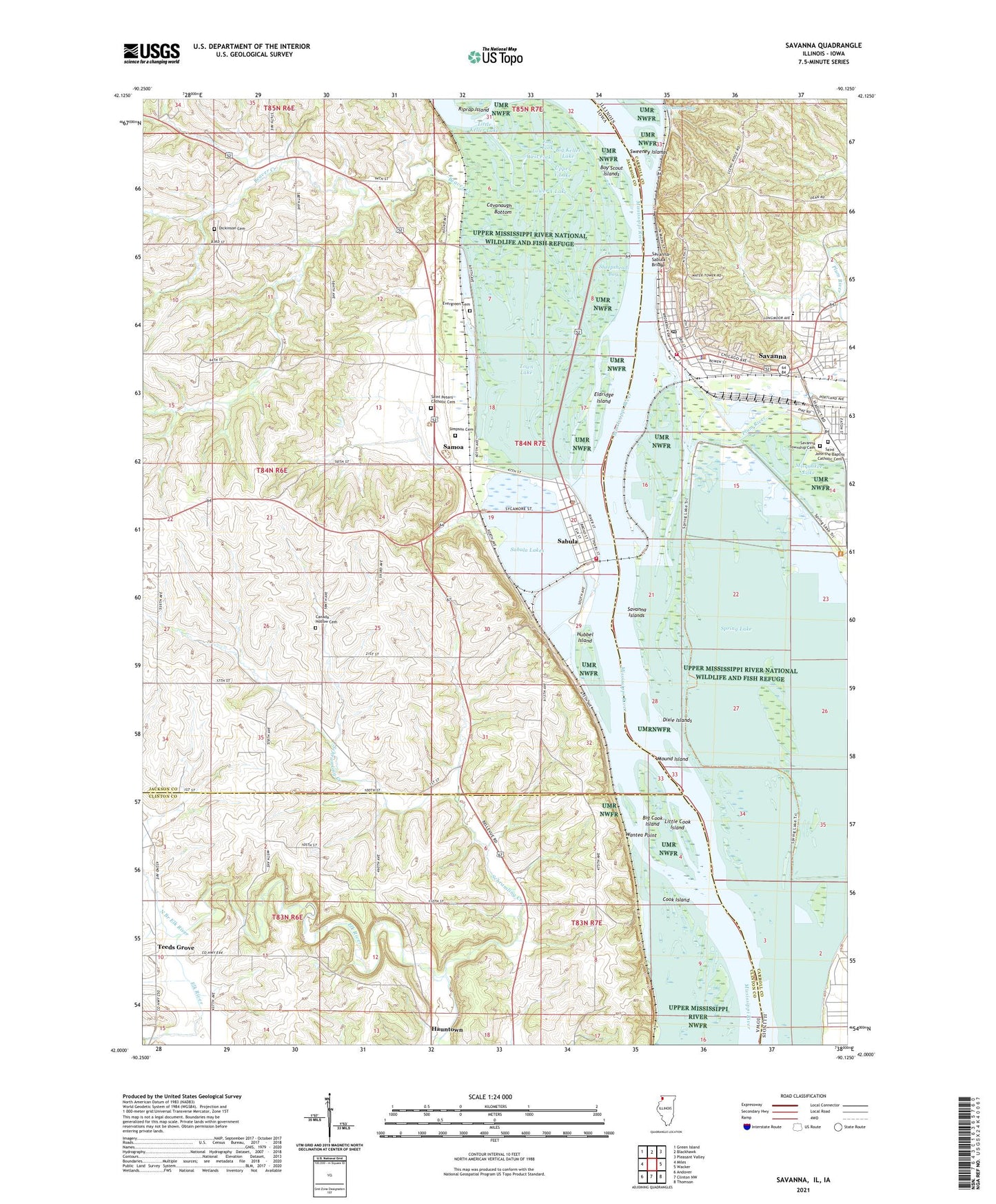
2024 topographic map quadrangle Savanna in the states of Iowa, Illinois. Scale: 1:24000. Based on the newly updated USGS 7.5' US Topo map series, this map is in the following counties: Carroll, Jackson, Clinton. The map contains contour data, water features, and other items you are used to seeing on USGS maps, but also has updated roads and other features. This is the next generation of topographic maps. Printed on high-quality waterproof paper with UV fade-resistant inks.
Quads adjacent to this one:
West: Miles
Northwest: Green Island
North: Blackhawk
Northeast: Pleasant Valley
East: Wacker
Southeast: Thomson
South: Clinton NW
Southwest: Andover
This map covers the same area as the classic USGS quad with code o42090a2.
Contains the following named places: Alligator Lake, Assembly of God Church, Avenue School, Bards Lake, Beaver Creek, Big Cook Island, Big Keller Lake, Big Sieber Lake, Bowens Lake, Boy Scout Islands, Calvary Baptist Church, Calvary Lutheran Church, Canada Hollow Cemetery, Cavanaugh Bottom, Chestnut Park School, City of Sabula, City of Savanna, Community United Church of Christ, Cook Island, Cook Slough, Dark Chute, Dead Lake, Dickinson Cemetery, Dixie Islands, Doc Wood Lake, East Central Elementary Center, East Central Middle School, East Fork, East Fork Sabula Slough, Edick Lake, Eldridge Island, Eldridge Slough, Esmay Slough, Evergreen Cemetery, First Presbyterian Church, First United Methodist Church, Hauntown, Hillside Stables Airport, Hubbel Island, Hubbel Slough, Island 266, Israel Day Lake, Jackson County Welcome Center, Joe Day Lake, L Esmay Slough, Lincoln Elementary School, Little Cook Island, Little Keller Lake, Lower Sabula Lake, Lower Y Lake, Maquette Park, Methodist Church, Middle Sabula Lake, Misquakee Lake, Mound Island, New Unity Church, North Branch Elk River, Oak Park Bible Church, Plum River, Reorganized Church of Jesus Christ of Latter Day Saints, Riprap Island, Sabula, Sabula Ambulance Service, Sabula City Hall, Sabula Lakes, Sabula Post Office, Sabula Public Library, Sabula Slough, Sabula Volunteer Fire Department, Saint John the Baptist Catholic Cemetery, Saint John the Baptist Catholic Church, Saint Pauls Episcopal Church, Saint Peters Catholic Cemetery, Saint Peters Catholic Church, Saint Peters Evangelical Lutheran Church, Samoa, Savanna, Savanna - Sabula Bridge, Savanna Bay, Savanna City Hospital Heliport, Savanna Community Ambulance, Savanna Fire Department, Savanna High School, Savanna Islands, Savanna Police Department, Savanna Post Office, Savanna Slough, Savanna Township Cemetery, Savanna Township Public Library, Savanna-Sabula Bridge, Schramling Creek, Sheepshead Bay, Sieber Lake, Simpson Cemetery, South Sabula Lakes Park, Spring Lake, Sunfish Lake, Sweeney Islands, Teeds Grove, Teeds Grove Post Office, Town Lake, Township of Savanna, Township of Union, Upper Sabula Lake, Upper West Fork West Sabula Slough, Upper Y Lake, Wantea Point, West Fork, ZIP Code: 52070