MyTopo
Anderson South Indiana US Topo Map
Couldn't load pickup availability
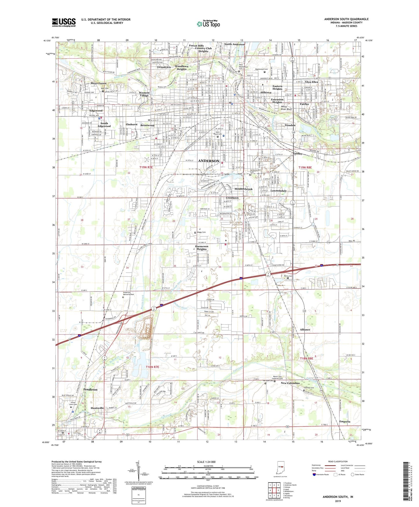
2022 topographic map quadrangle Anderson South in the state of Indiana. Scale: 1:24000. Based on the newly updated USGS 7.5' US Topo map series, this map is in the following counties: Madison. The map contains contour data, water features, and other items you are used to seeing on USGS maps, but also has updated roads and other features. This is the next generation of topographic maps. Printed on high-quality waterproof paper with UV fade-resistant inks.
Quads adjacent to this one:
West: Lapel
Northwest: Frankton
North: Anderson North
Northeast: Gilman
East: Middletown
Southeast: Shirley
South: Pendleton
Southwest: Ingalls
This map covers the same area as the classic USGS quad with code o40085a6.
Contains the following named places: Ace Airpark, Alliance, Anderson, Anderson Fire Department, Anderson Fire Department Station 1 Headquarters, Anderson Fire Department Station 2, Anderson Fire Department Station 3, Anderson Fire Department Station 6, Anderson Fire Department Station 7, Anderson Fire Department Station 8, Anderson High School, Anderson Memorial Park, Anderson Police Department, Anderson Post Office, Anderson University, Belmont Church, Bethel Church, Brentwood, Bucco Cemetery, Central Avenue School, Circle Park, City of Anderson, Columbia School, Country Club Heights, Crestlawn, Denny Field, East Side Church, Eastern Heights, Edgewater Park, Edgewood, Edgewood Country Club, Edgewood Elementary School, Edgewood Fire Department, Edgewood Police Department, Eldorado School, Elmhurst, Emergency Medical Ambulance Service of Madison County, Emporia, Extension Heights, Fairfax, Fairfax Church, Fairview Park, Fall Creek Heights School, Falls Park, Forest Hills, Franklin Elementary School, Gilmore Cemetery, Glyn Ellen, Grandview, Grandview Country Club, Great Commission School, Gridley, Grove Lawn Cemetery, Harmeson Heights, Highland Senior High School, Hillcrest, Horne Park, Hubbard Park, Huntsville, Irondale, Killbuck Creek, Lindberg School, Longfellow School, Lowmandale, Madison County Sheriff's Office, Madison Heights High School, Madison Park, Maplewood Cemetery, Meadowbrook, Meadowbrook Elementary School, Meadowbrook Park, Michael Ditch, Moss Cemetery, Mounds Church, Mount Zion Church, Mount Zion Lutheran Cemetery, New Columbus, Orebaugh Ditch, Park Place Elementary School, Park Road Church, Pee Wee Cemetery, Pendleton Emergency Ambulance Service, Pendleton Fire Department, Pendleton Police Department, Pendleton Post Office, Pendleton Quarry, Pittsford Ditch, Prairie Creek, Puiaski Park, Riley Park, Riley School, River Forest, Rolling Hills Convalescent Center Airport, Roosevelt School, Saint Ambrose School, Saint Marys Cemetery, Saint Marys School, Saint Vincent Anderson Hospital, Seventh Street School, Shadeland Elementary School, South Edgewood, South Side Middle School, Spring Branch, Stanley Ditch, Stanton Park, Sugar Fork, Tenth Street Elementary School, Town of Country Club Heights, Town of Edgewood, Town of River Forest, Town of Woodlawn Heights, Township of Anderson, Twenty-Fifth Street Elementary School, Vandeventer Cemetery, Waggy Cemetery, Washington School, West Maplewood Cemetery, Western Village, Westvale Elementary School, WHBU-AM (Anderson), Whetstone Church, White River Bluff, WHUT-AM (Anderson), WLHN-FM (Anderson), Woodlawn Heights, ZIP Codes: 46013, 46016