MyTopo
Boone West Iowa US Topo Map
Couldn't load pickup availability
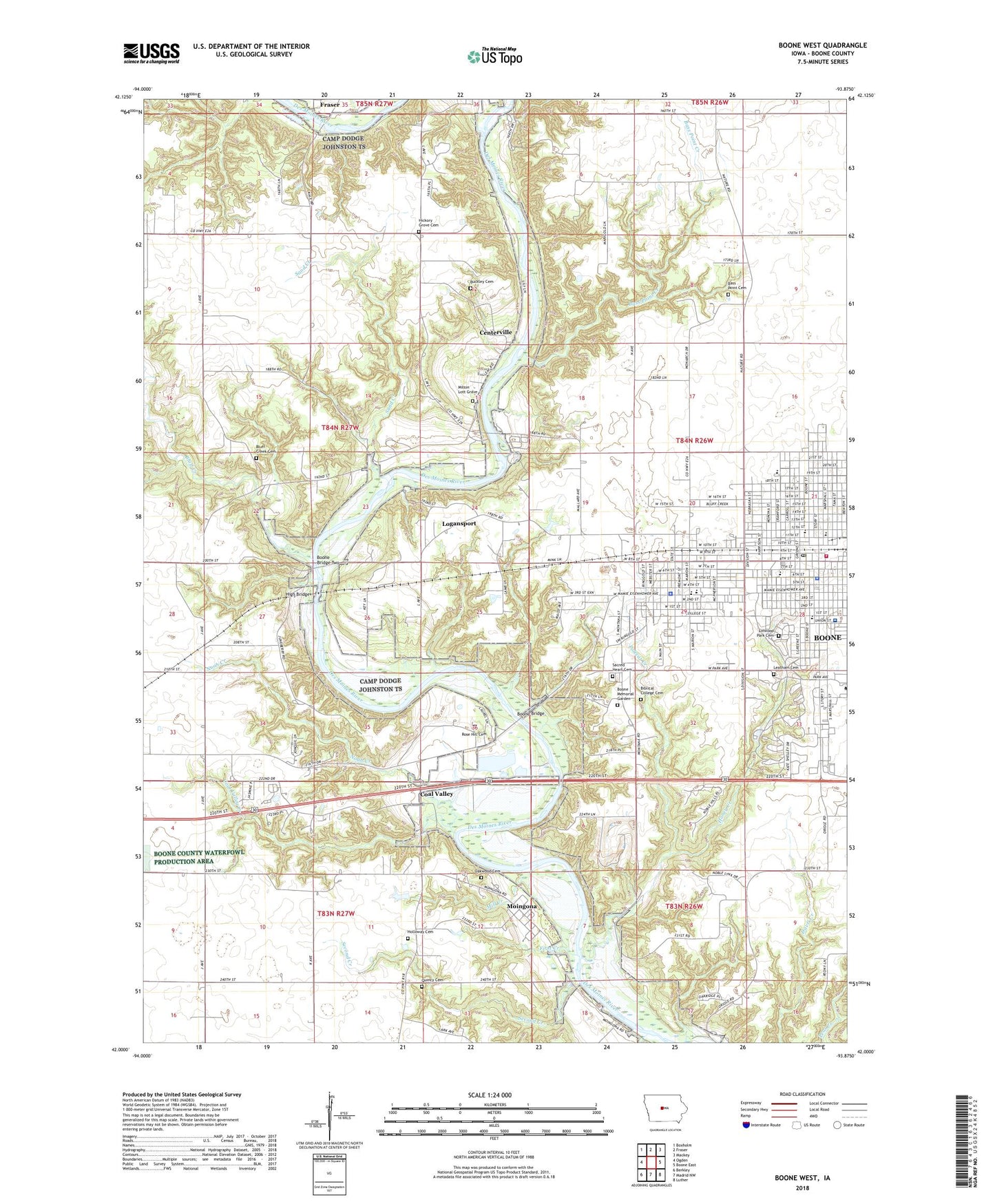
2022 topographic map quadrangle Boone West in the state of Iowa. Scale: 1:24000. Based on the newly updated USGS 7.5' US Topo map series, this map is in the following counties: Boone. The map contains contour data, water features, and other items you are used to seeing on USGS maps, but also has updated roads and other features. This is the next generation of topographic maps. Printed on high-quality waterproof paper with UV fade-resistant inks.
Quads adjacent to this one:
West: Ogden
Northwest: Boxholm
North: Fraser
Northeast: Mackey
East: Boone East
Southeast: Luther
South: Madrid NW
Southwest: Berkley
This map covers the same area as the classic USGS quad with code o42093a8.
Contains the following named places: Anderson Park, Augustana Lutheran Church, Bass Point Cemetery, Bass Point Creek, Battin Chapel, Berean Baptist Church, Biblical College Cemetery, Birthplace of Mamie D Eisenhower Historical Marker, Bluff Creek, Bluff Creek Cemetery, Boone, Boone Biblical Memorial Church, Boone Bridge, Boone Bridge Two, Boone Campus Library, Boone County, Boone County Courthouse, Boone County Historical Center, Boone County Hospital, Boone Family Practice Center, Boone Fire Department, Boone High School, Boone Memorial Garden, Boone Police Department, Boone Post Office, Boonesboro Post Office, Buckley Cemetery, Camp Sacalawea, Centerville, Central Christ Church, Centre for Obstetrics and Gynecology, Christian School, Church of God of Prophecy, Church of the Nazarene, Church of the Open Bible, City of Boone, City of Fraser, Coal Valley, Coal Valley Creek, Cornerstone Alliance Church, Country Aire Mobile Home Park, Cummings Park, Dayspring Haven Camp, Des Moines Area Community College - Boone Campus, District Court Judge, Dragoon Trail in Boone County Historical Marker, Eastern Star Masonic Home, Ericson Public Library, Evangelical Free Church, Evangelical Free Church Home, First Baptist Church, First Creek, First Presbyterian Church, First United Methodist Church, Franklin Elementary School, Franklin Park, Fraser, Futures Alternative High School, Garfield School, Goeppinger Field, Grace Episcopal Church, Heartland Health Center, Herman Park, Hickory Grove Cemetery, High Bridge, Historical Museum of Boone County, Holloway Cemetery, Holst State Forest, Honey Creek, Incline Post Office, Internal Medicine Center, Kate Shelley Memorial Park, Kate Shelley Railroad Museum, KDLF-AM (Boone), KFGQ-FM (Boone), Kingdom Hall of Jehovah's Witnesses, KTIA-FM (Boone), KWBG-AM (Boone), KWBG-FM (Boone), Latham Cemetery, Lincoln Elementary School, Linwood Park Cemetery, Little League Park, Logansport, Mamie Doud Eisenhower Birthplace, McFarland Clinic, McHose Park, Memorial Park, Miles-Lee Park, Mill Creek, Milton Lott Grave, Moingona, Moingona Post Office, Noah Creek, Oakwood Cemetery, Page Elementary School, Polecat Creek, Quincy Cemetery, River Side Post Office, Riverside Post Office, Rose Hill Cemetery, Sacred Heart Catholic Church, Sacred Heart Cemetery, Sacred Heart School, Saint Marion United Methodist Church, Sand Creek, Second Creek, Third Creek, Township of Des Moines, Township of Yell, Trinity Lutheran Church, Trinity Lutheran School, Yough